Komchen

Last updated
Komchén
Town
Mexico Yucatan location map.svg
Red pog.svg
Komchén
Location of Merida in Yucatán
Mexico States blank map.svg
Red pog.svg
Komchén
Komchén (Mexico)
Coordinates: 21°06′13″N89°39′45″W / 21.10361°N 89.66250°W / 21.10361; -89.66250 Coordinates: 21°06′13″N89°39′45″W / 21.10361°N 89.66250°W / 21.10361; -89.66250
CountryFlag of Mexico.svg  Mexico
StateFlag of Yucatan.svg  Yucatán
MunicipalityEscudo de Merida Yucatan.svg Mérida
Population (2005 [1] )
  Total3,778
Time zone UTC-6 (Central Standard Time)
  Summer (DST) UTC-5 (Central Daylight Time)
Major Airport Merida (Manuel Crescencio Rejón) International Airport
IATA Code MID
ICAO Code MMMD
Website Merida

Komchén is a community in the Mérida Municipality in the state of Yucatán, located in southeastern Mexico. Komchén is located 15 kilometers north of the city of Mérida, in the northwestern portion of the Yucatán Peninsula and is approximately 20 km from the northern peninsular coast. Its name comes from the Yucatec Mayan and means: In the well of the hollow. Its infrastructure includes, educational services (a kindergarten, a primary school, a high school and a Bachelors School and a municipal library), a clinic of the Mexican Social Security Institute as well as recreational parks and marinas. 90% of Its streets are paved.

Mexico Country in the southern portion of North America

Mexico, officially the United Mexican States, is a country in the southern portion of North America. It is bordered to the north by the United States; to the south and west by the Pacific Ocean; to the southeast by Guatemala, Belize, and the Caribbean Sea; and to the east by the Gulf of Mexico. Covering almost 2,000,000 square kilometres (770,000 sq mi), the nation is the fifth largest country in the Americas by total area and the 13th largest independent state in the world. With an estimated population of over 120 million people, the country is the eleventh most populous state and the most populous Spanish-speaking state in the world, while being the second most populous nation in Latin America after Brazil. Mexico is a federation comprising 31 states and Mexico City, a special federal entity that is also the capital city and its most populous city. Other metropolises in the state include Guadalajara, Monterrey, Puebla, Toluca, Tijuana and León.

Yucatán Peninsula peninsula in North America

The Yucatán Peninsula, in southeastern Mexico, separates the Caribbean Sea from the Gulf of Mexico, with the northern coastline on the Yucatán Channel. The peninsula lies east of the Isthmus of Tehuantepec, a northwestern geographic partition separating the region of Central America from the rest of North America. It is approximately 181,000 km2 (70,000 sq mi) in area, and is almost entirely composed of limestone.

Mexican Social Security Institute Public institution of social security

The Mexican Social Security Institute is a governmental organization that assists public health, pensions and social security in Mexico operating under Secretaría de Salud.

Pre-Columbian History

Komchén is also the location of a pre-Columbian Maya archaeological site of the same name and is situated close to the site of Dzibilchaltun. Pre-Columbian Komchén was initially settled during the Mesoamerican Middle Preclassic. Its earliest settlement consisted of a small residential community with perishable structure. The site transitioned into a larger community during the Late Preclassic, reaching its peak in construction between the years 350-150 BC [2] and employing permanent stone masonry in architectural construction. It appears that the site was entirely abandoned by the end of the Late Preclassic (ca. A.D. 250). Later, however, the site was partially reoccupied by residents of the expanding center of Dzibilchaltun.

Maya civilization Mesoamerican civilization

The Maya civilization was a Mesoamerican civilization developed by the Maya peoples, and noted for its logosyllabic script—the most sophisticated and highly developed writing system in pre-Columbian Americas—as well as for its art, architecture, mathematics, calendar, and astronomical system. The Maya civilization developed in an area that encompasses southeastern Mexico, all of Guatemala and Belize, and the western portions of Honduras and El Salvador. This region consists of the northern lowlands encompassing the Yucatán Peninsula, and the highlands of the Sierra Madre, running from the Mexican state of Chiapas, across southern Guatemala and onwards into El Salvador, and the southern lowlands of the Pacific littoral plain.

Archaeological site Place in which evidence of past activity is preserved

An archaeological site is a place in which evidence of past activity is preserved, and which has been, or may be, investigated using the discipline of archaeology and represents a part of the archaeological record. Sites may range from those with few or no remains visible above ground, to buildings and other structures still in use.

Dzibilchaltun Maya archaeological site with cenote in Yucatan, Mexico

Dzibilchaltún is a Maya archaeological site in the Mexican state of Yucatán, approximately 10 miles (16 km) north of state capital Mérida.

Archaeological investigation of the site commenced during the early 1980s when a research project, under the direction of E. Wyllys Andrews V of the Middle American Research Institute (MARI) of Tulane University, began excavating at Komchén. [3] This research documented nearly 1000 residential structures in an area approximately 2 km² in size, including a core of five large platforms (the tallest of which was 8 meters) and a sacbe (one of the earliest identified in the Yucatán) (Andrews et al. 1984).

Archaeology, or archeology, is the study of human activity through the recovery and analysis of material culture. The archaeological record consists of artifacts, architecture, biofacts or ecofacts and cultural landscapes. Archaeology can be considered both a social science and a branch of the humanities. In North America archaeology is a sub-field of anthropology, while in Europe it is often viewed as either a discipline in its own right or a sub-field of other disciplines.

The Middle American Research Institute was established at Tulane University in 1924.

Tulane University private university in New Orleans, Louisiana, United States

Tulane University is a private, nonsectarian research university in New Orleans, Louisiana, United States. It is the top university and the most selective institution of higher education in the state of Louisiana. The school is known to attract a geographically diverse student body, with 85 percent of undergraduate students coming from over 300 miles away.

Related Research Articles

Becan

Becan is an archaeological site of the Maya civilization in pre-Columbian Mesoamerica. Becan is located near the center of the Yucatán Peninsula, in the present-day Mexican state of Campeche, about 150 km (93.2 mi) north of Tikal. The Maya sites of Balamku, Calakmul, Chicanna and Xpuhil are nearby. The name Becan was bestowed on the site by archaeologists who rediscovered the site, meaning "ravine or canyon formed by water" in Yukatek Maya, after the site's most prominent and unusual feature, its surrounding ditch.

Mayapan

Mayapan, , is a Pre-Columbian Maya site a couple of kilometers south of the town of Telchaquillo in Municipality of Tecoh, approximately 40 km south-east of Mérida and 100 km west of Chichen Itza; in the state of Yucatán, Mexico. Mayapan was the political and cultural capital of the Maya in the Yucatán Peninsula during the Late Post-Classic period from the 1220s until the 1440s. Estimates of the total city population are 15,000–17,000 persons, and the site has more than 4,000 structures within the city walls, and additional dwellings outside.

Izamal City in Yucatan, Mexico

Izamal is a small city in the Mexican state of Yucatán, 72 km east of state capital Mérida, in southern Mexico.

Maya ruins of Belize archaeological Maya site in Belize‎‎

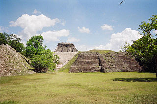
The Maya ruins of Belize include a number of well-known and historically important pre-Columbian Maya archaeological sites. Belize is considered part of the southern Maya lowlands of the Mesoamerican culture area, and the sites found there were occupied from the Preclassic until and after the arrival of the Spanish in the 16th century.

Sacbe

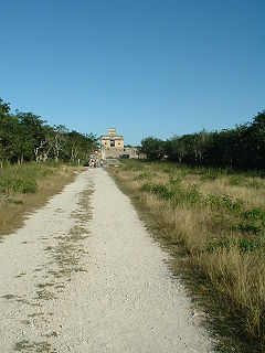
A sacbe, plural sacbeob, or "white way", is a raised paved road built by the Maya civilization of pre-Columbian Mesoamerica. Most connect temples, plazas, and groups of structures within ceremonial centers or cities, but some longer roads between cities are also known. The term "sacbe" is Yucatec Maya for "white road"; white perhaps because there is evidence that they were originally coated with limestone stucco or plaster, which was over a stone and rubble fill.

Mesoamerica Cultural area in the Americas

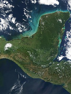
Mesoamerica is a historical region and cultural area in North America. It extends from approximately central Mexico through Belize, Guatemala, El Salvador, Honduras, Nicaragua, and northern Costa Rica, and within this region pre-Columbian societies flourished before the Spanish colonization of the Americas. In the 16th century, European diseases like smallpox and measles caused the deaths of upwards of 90% of the indigenous people. It is one of five areas in the world where ancient civilization arose independently, and the second in the Americas along with Norte Chico (Caral-Supe) in present-day Peru, in the northern coastal region.

Ake Mayan archaeological site

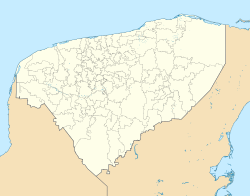
Ake is an archaeological site of the pre-Columbian Maya civilization. It’s located in the municipality of Tixkokob, in the Mexican state of Yucatán; 40 km (25 mi) east of Mérida, Yucatán.

Chunchucmil

Chunchucmil was once a large, sprawling pre-Columbian Maya city located in the western part of what is now the state of Yucatán, Mexico.

The Petén Basin is a geographical subregion of Mesoamerica, primarily located in northern Guatemala within the Department of El Petén, and into Campeche state in southeastern Mexico.

Oxkintok

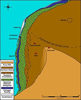
Oxkintok is a pre-Columbian Maya archaeological site in the Puuc region of Yucatán state, in southeastern Mexico.

Chichen Itza pre-Columbian city

Chichen Itza was a large pre-Columbian city built by the Maya people of the Terminal Classic period. The archaeological site is located in Tinúm Municipality, Yucatán State, Mexico.

Nohmul pre-Columbian Maya archaeological site

Nohmul is a pre-Columbian Maya archaeological site located on the eastern Yucatán Peninsula, in what is today northern Belize. The name Nohmul may be translated as "great mound" in Yucatec Maya. It is the most important Maya site in northern Belize. The site included a large pyramid, about 17 meters (56 ft) tall, built around 250 BC. Most of the pyramid was destroyed in May 2013 by contractors tearing it apart for rocks and gravel to use to fill roads, leaving only the core of the pyramid behind.

Preclassic Maya

The Preclassic period in Maya history stretches from the beginning of permanent village life c. 1000 BC. until the advent of the Classic Period c. 250 AD, and is subdivided into Early, Middle, and Late. Major archaeological sites of this period include Nakbe, Uaxactun, Seibal, San Bartolo, Cival, and El Mirador in Guatemala; Cahal Pech, Blackman Eddy, and Cerros in Belize; and Calakmul, Yaxnohcah, Ichkabal, Komchen, and Xocnaceh in Mexico.

Maya stelae Intricately carved stone slabs made by the Pre-Columbian Maya

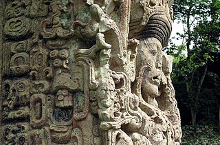
Maya stelae are monuments that were fashioned by the Maya civilization of ancient Mesoamerica. They consist of tall, sculpted stone shafts and are often associated with low circular stones referred to as altars, although their actual function is uncertain. Many stelae were sculpted in low relief, although plain monuments are found throughout the Maya region. The sculpting of these monuments spread throughout the Maya area during the Classic Period, and these pairings of sculpted stelae and circular altars are considered a hallmark of Classic Maya civilization. The earliest dated stela to have been found in situ in the Maya lowlands was recovered from the great city of Tikal in Guatemala. During the Classic Period almost every Maya kingdom in the southern lowlands raised stelae in its ceremonial centre.

Edward Barna Kurjack American anthropologist

Edward Barna Kurjack was a Mayan anthropologist who was known for his contributions to the study of Mayan settlement patterns and society.

Santa Rita is a Maya ruin and an archaeological reserve on the outskirts of Corozal, Belize. Historical evidence suggests that it was probably the ancient and important Maya city known as Chetumal.

Kʼo archaeological Maya site in Guatemala‎

Kʼo is one of several Mayan ceremonial center sites around and associated with the Classic Mayan city of Holmul located in modern-day Guatemala. Currently, the site boasts what may be the royal tomb of the earliest known Mayan ruler.

History of the Maya civilization

The history of Maya civilization is divided into three principal periods: the Preclassic, Classic and Postclassic periods; these were preceded by the Archaic Period, which saw the first settled villages and early developments in agriculture. Modern scholars regard these periods as arbitrary divisions of chronology of the Maya civilization, rather than indicative of cultural evolution or decadence. Definitions of the start and end dates of period spans can vary by as much as a century, depending on the author. The Preclassic lasted from approximately 2000 BC to approximately 250 AD; this was followed by the Classic, from 250 AD to roughly 950 AD, then by the Postclassic, from 950 AD to the middle of the 16th century. Each period is further subdivided:

References

  1. Census Results by Locality, 2005 Archived July 22, 2011, at the Wayback Machine. INEGI.
  2. Sharer, Robert J. The Ancient Maya, 5th edition., page 130 Stanford University Press, Stanford. 1994. ISBN   0-8047-2310-9
  3. Andrews, E. Wyllys, V, Ringle William M., Barnes P.J. Komchen, an Early Maya Community in Northwest Yucatán. In Investigaciones recientes en el área maya 1:73-92. XVII Mesa Redonda, Sociedad Mexicana de Antropologia, Mexico City, 1984