La Milpa

Last updated

La Milpa is an archaeological site and an ancient Maya city within the Three River region of Northwest Belize bordering Mexico and Guatemala. La Milpa is located between the sites of Rio Azul and Lamanai. Currently, La Milpa lies within the nature preserve owned by the Programme for Belize, a non-profit organization. [1] PfB acquired land for the preserve from the Coco-Cola Company, who purchased land in Belize in 1988 with the goals of tearing down the rainforest to create a citrus plantation, however donated the land to Conservation and Management Project in 1990 and 1992. Following Caracol and Lamanai, La Milpa is the third largest site in Belize with the Main Plaza alone covering 18,000 square meters, making it one of the largest in the entire Maya region.

Contents

Research History

This site was first discovered in March 1938 by Sir J. Eric S. Thompson. [2] [3] Thompson’s work at La Milpa entailed mapping and excavating the Main Center, recording a total of 12 different stelae. Thompson noted that there was a line of stelae along the Great Plaza, however they were badly weathered. These stelae were made of a soft limestone that came from the bedrock within the PfB area. According to Nikolai Grube, the composition of this material accounted for why the stelae were so eroded. [4] [5] Nonetheless, Thompson was able read a date on Stela 7 of 9.17.10.0.0. (November 30, 780). [6] [7] [8] Thompson’s work was short lived at La Milpa however, due a bout of dysentery that cut his season short.

After Thompson, La Milpa was not explored again until the 1970s, when David M. Pendergast and Stanley Loten conducted a field project at the site. Their work largely centered on adding to the existing map of the main plaza. After Pendergast and Loten, two archaeologists in 1979 from the Department of Archaeology in Belmopan went to La Milpa to confirm reports of looting. [9] [10] Their surveys confirmed that the site had been heavily looted. In 1985, the Department of Archaeology revisited La Milpa again because of reports of looting and additionally due to the speculation of the presence of marijuana fields. On this expedition, they confirmed both reports, noting that all the main structures within the site center had large trenches revealing older constructions and/or tombs.

Archaeological research continued at La Milpa in 1988 when two different groups each with different objectives started investigations. The first group, The Rio Bravo Project, went to sketch the site center. The second group, the PfB, went to research the site for the potential ability to contribute to the archaeological record. [11] [12] [13] The mapping done during these investigations showed the Main Plaza, the outlying courtyards and the location of stelae, as well as the trenches from looting.

Thomas Guderjan, who was part of the original exploration by the Rio Bravo Project, returned in February 1990 to continue mapping the site and the outlying areas. Within this field season, Guderjan produced maps of four plazas, 20 residential courtyards, and 85 structures. While all these occur within a 1 km by .5 km area, Guderjan inferred that site could have had as many as 24 to 30 different courtyards. Guderjan also renumbered the stelae, however LaMAP and other scholars have since utilized Thompson’s original numbering. [14] [15] In February 1992, Boston University and the La Milpa Archaeological Project (LaMAP) started extensive excavations and mapping of the site.

LaMAP

The first field season in 1992, under the direction of Dr. Norman Hammond and Dr. Gair Tourtellot, utilized multiple different fields of study including epigraphy, mapping, and excavations, to gain as much data as possible. The LaMAP project only holds a permit to excavate within a 6 km radius from the site center. Consequently, the excavations outside of this region were part of a different project directed by Dr. Richard E. W. Adams of the University of Texas at San Antonio and later by Dr. Fred Valdez of University of Texas at Austin, under the Programme for Belize Archaeological Project (PfBAP). [16] [17]

Research within the first years was conducted at four main areas. The first being the La Milpa Center (LMC), second the three radiating radial transects from LMC, the third area consisting of four minor plazas, and finally, the fourth consisting of 15 random 250m by 250m survey blocks. Additional research has been research conducted by the Ancient Maya Land and Water Use Project, which has investigated the water drainage from the site center outwards.

Site Layout

The site is situated on a ridge roughly 1 km across, running from North to South, with the drainage going to the western side. There are no natural water sources within the site, however there are two large aguadas that would have held water through the dry season. While there are no other permanent water sources, in 1992 Vernon L. Scarborough investigated the possibility of two other reservoirs which were initially stone quarries thought to retain water.

The site is structured with the Petén-centric site plan, meaning a northern grouping of buildings surrounding the main plaza (Plaza A). This plaza is over 18,000 square meters and could have held upwards of 17,000 people. On the eastern side of this plaza are the construction of three large pyramid temples surrounding a fourth in the center in the middle of the plaza. The southern part of the plaza consists of a range of building while the northern part contains low walls that make up the northwest corner of the plaza.

South of the Great Plaza, lies another group of buildings, which consist of three open plazas with enclosed courtyards. This area had only one pyramid and no stelae or altars. This area was not of interest until later in the project when research goals did include the southern region of the site center as well as the hinterlands that were within the 6 km radius from the center.

Site History

Late Preclassic/ Early Classic 400 BC- AD 500

During the Late Preclassic and Early Classic La Milpa was a small site located on a hilltop consisting of a few pyramids, one reservoir, and a few stelae. Excavations within Plaza A revealed a few monuments that date to this period indicating a growing population and therefore a need for increased space. The northern plaza was also occupied during this period. It was the foci of funerary monumental construction, which has led to the interpretation the dead were buried near the main population. The only other signs of occupation during this time can be seen in the alteration of the surrounding landscapes, such as construction of terraces.

These changes may have occurred to do that advent of kingship and elite classes during the Late Preclassic. [18] In addition, the archaeological record suggests that the Maya divinity controlled the population and therefore, the population was concentrated around the center monumental constructions. While these changes occurred fairly rapidly, the population and site stayed small and concentrated.

During the Early Classic Period La Milpa saw significant growth in the production of monumental constructions the site center. The stelae also reflected change, indicating a shift towards political states with institutionalized royalty and a strong stable political system. [19] [20] [21] [22] These changes reflect the growing political complexity as resource management became a tool of the state due to the increasing population density. In particular, power was negotiated by rulership through the ability to control the agriculture and the environment. Despite the growth of the site population and density during the Early Classic Period, La Milpa was able to sustain a large population; however, there is a marked pause in the culturalism of the Maya within this region during the Middle Classic Period.

Middle Classic AD 550 - 700

The Middle Classic Period is marked by a decline in culture and populations within La Milpa and the other Three River sites. This change can be attributed to the population shift that occurred within the Three Rivers Basin due to the ongoing conflict between larger cities such as Tikal, Caracol, and Calakmul. The region saw a decline in both in populations and the controlling elite power. This “cultural pausing” can be seen in the archaeological record due to the lack of new monumental constructions and elite artworks. Stelae dedications ended with the advent of the Middle Classic Period and did not resume until the Late Classic Period during a cultural revival.

Late/Terminal Classic 700–850

At La Milpa during the mid-8th century, there was a steep upward climb in the construction of monumental architecture and the dedication of stelae. This increase in activity can be directly related to the change in settlement patterns outside of the site core. The Petén-centric site plan became the site pattern for the main plaza of sites within the Three Rivers Basin. With this Petén-centric site plan, there is a regrowth in populations and elite centers.

Along with the change in site plan patterns, there is also the construction of two ballcourts within the site. These ballcourts were designed with a specific layout that would orient them from north to south and west to east. While there was a cultural revitalization and a burst in population, the revitalization only lasted for a short while. [23] [24] [25] [26] Following the revitalization in the Late Classic Period, La Milpa and the surrounding sites experienced decline and eventually collapse along with the rest of the Maya realm. The collapse at La Milpa appears to have been rapid as indicated by the partial completion of monumental constructions along with other signs of sudden abandonment in the archaeological record.

The site of La Milpa was occupied from the Pre-classic and Early Classic into the Late and Terminal Classic, reaching its peak during the Early Classic Period. La Milpa had intensive agriculture as indicated by extensive terraces. The site had a number of monumental constructions and other elite artworks, indicating centralized power. While the site has been subjected to numerous archaeological investigations, La Milpa remains largely unexplored.

Notes

  1. Norman Hammond, 1991
  2. Norman Hammond 2001
  3. Norman Hammond et al. 1998
  4. Nikolai Grube 1994
  5. Nikolai Grube 1998
  6. Norman Hammond 2001
  7. Norman Hammond et al. 1998
  8. Norman Hammond, 1991
  9. Norman Hammond,1991
  10. Norman Hammond et al., 1998
  11. Norman Hammond et al.,1998
  12. Kerry Sagebeil,2005
  13. Norman Hammond et al., 1996
  14. Kerry Sagebeil,2005
  15. Norman Hammond et al., 1996
  16. Kerry Sagebeil,2005
  17. Norman Hammond,1991
  18. Kerry Sagebeil,2005
  19. Kerry Sagebeil,2005
  20. Norman Hammond et al. 1994
  21. Nikolai Grube 1994
  22. Nikolai Grube 1998
  23. Kerry Sagebeil,2005
  24. K.C. Schultz 1994
  25. Norman Hammond et al. 1998
  26. Norman Hammond et al. 2004

See also

Related Research Articles

<span class="mw-page-title-main">Copán</span> Maya archaeological site in western Honduras

Copán is an archaeological site of the Maya civilization in the Copán Department of western Honduras, not far from the border with Guatemala. It is one of the most important sites of the Maya civilization, which was not excavated until the 19th century. The ruined citadel and imposing public squares reveal the three main stages of development before the city was abandoned in the early 10th century.

<span class="mw-page-title-main">Tikal</span> Ruins of major ancient Maya city

Tikal is the ruin of an ancient city, which was likely to have been called Yax Mutal, found in a rainforest in Guatemala. It is one of the largest archeological sites and urban centers of the pre-Columbian Maya civilization. It is located in the archeological region of the Petén Basin in what is now northern Guatemala. Situated in the department of El Petén, the site is part of Guatemala's Tikal National Park and in 1979 it was declared a UNESCO World Heritage Site.

<span class="mw-page-title-main">Nim Li Punit</span>

Nim Li Punit is a Maya Classic Period site in the Toledo District of the nation of Belize, located 50 kilometres north of the town of Punta Gorda, and directly adjacent to the village of Indian Creek. Nim Li Punit is sometimes known as Big Hat or Top Hat; the name is Kekchi Maya for "Big Hat", referring to the large elaborate head-dress on a stela sculpture found on site depicting one of the site's ancient kings. It is bordered by the Maya Mountains to the west and lowland swamps and the Caribbean Sea to the east.

<span class="mw-page-title-main">Seibal</span> Archaeological site of the Maya civilization

Seibal, known as El Ceibal in Spanish, is a Classic Period archaeological site of the Maya civilization located in the northern Petén Department of Guatemala, about 100 km SW of Tikal. It was the largest city in the Pasión River region.

Naachtun is an archaeological site of the pre-Columbian Maya civilization, situated at the northeastern perimeter of the Mirador Basin region in the southern Maya lowlands, now in the modern-day Department of El Petén, northern Guatemala. Naachtun was a major center of the region by the late Formative Period, and was one of the few Formative Period Mirador Basin centers which continued to flourish into the succeeding Classic period.

<span class="mw-page-title-main">Ixlu</span> Archaeological site in Flores, Guatemala

Ixlu is a small Maya archaeological site that dates to the Classic and Postclassic Periods. It is located on the isthmus between the Petén Itzá and Salpetén lakes, in the northern Petén Department of Guatemala. The site was an important port with access to Lake Petén Itzá via the Ixlu River. The site has been identified as Saklamakhal, also spelt Saclemacal, a capital of the Kowoj Maya.

Río Azul is an archaeological site of the Pre-Columbian Maya civilization. It is the most important site in the Río Azul National Park in the Petén Department of northern Guatemala, close to the borders of Mexico and Belize. Río Azul is situated to the southeast of the Azul river and its apogee dates to the Early Classic period.

<span class="mw-page-title-main">Uxbenka</span> Ancient Maya archaeological site in Belize

Uxbenka is a pre-Columbian Mesoamerican archaeological site located in Belize's southernmost district of Toledo. An urban settlement of the pre-Columbian Maya, it is the earliest-known Maya polity in the southern Belizean lowlands, with evidence of occupation dating to the Early Classic period of Mesoamerican chronology. It is one of five major Maya sites in this region, whose archaeological sites also include Nim Li Punit and Lubaantun. Settlement of Uxbenka has been suggested to have occurred originally by Peten peoples. The site is approximately 40 square kilometers in size, and Uxbenka is referred to as a medium-sized polity ). Uxbenka rose shortly after the expansion of another Maya site, Tikal. The site is thought to have been first inhabited during the late Preclassic period.

The Preclassic period in Maya history stretches from the beginning of permanent village life c. 1000 BC until the advent of the Classic Period c. 250 AD, and is subdivided into Early, Middle, and Late. Major archaeological sites of this period include Nakbe, Uaxactun, Seibal, San Bartolo, Cival, and El Mirador.

<span class="mw-page-title-main">Maya stelae</span> Intricately carved stone slabs made by the Pre-Columbian Maya

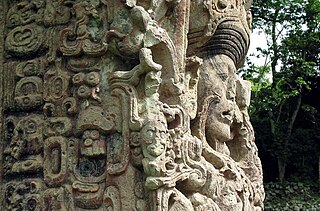
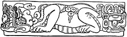
Maya stelae are monuments that were fashioned by the Maya civilization of ancient Mesoamerica. They consist of tall, sculpted stone shafts and are often associated with low circular stones referred to as altars, although their actual function is uncertain. Many stelae were sculpted in low relief, although plain monuments are found throughout the Maya region. The sculpting of these monuments spread throughout the Maya area during the Classic Period, and these pairings of sculpted stelae and circular altars are considered a hallmark of Classic Maya civilization. The earliest dated stela to have been found in situ in the Maya lowlands was recovered from the great city of Tikal in Guatemala. During the Classic Period almost every Maya kingdom in the southern lowlands raised stelae in its ceremonial centre.

KaʼKabish is an archaeological site in the Orange Walk District of Belize, Central America, located near the Maya sites of Lamanai, El Pozito, and Blue Creek. It was once a moderate sized city, built as part of the Maya civilization, and has been determined to have been largely autonomous throughout its history. The modern communities of Indian Church and San Filipe are in close proximity to KaʼKabish, and the Mennonite community of Blue Creek is slightly further afield. A road connecting Indian Church to San Filipe separates the site into two areas, the North Complex and the South Complex.

<span class="mw-page-title-main">Sacul, El Petén</span>

Sacul is an archaeological site of the Maya civilization located in the upper drainage of the Mopan River, in the Petén department of Guatemala. The city occupied an important trade route through the Maya Mountains. The main period of occupation dates to the Late Classic Period. In the late 8th century AD through to the early 9th century, Sacul was one of the few kingdoms in the southeastern Petén region to use its own Emblem Glyph, together with Ixtutz and Ucanal.

<span class="mw-page-title-main">Nikolai Grube</span> German Mesoamericanist

Nikolai Grube is a German epigrapher. He was born in Bonn in 1962. Grube entered the University of Hamburg in 1982 and graduated in 1985. His doctoral thesis was published at the same university in 1990. After he received his doctorate, Grube moved to the University of Bonn. Nikolai Grube has been heavily involved in the decipherment of the Maya hieroglyphic script.

Itzam Kʼan Ahk II, also known as Ruler 4, was an ajaw of Piedras Negras, an ancient Maya settlement in Guatemala. He ruled during the Late Classic Period, from 729 to 757 AD. Itzam Kʼan Ahk II ascended to the throne following the death of Kʼinich Yoʼnal Ahk II. Itzam Kʼan Ahk II may have fathered the following three kings of Piedras Negras: Yoʼnal Ahk III, Haʼ Kʼin Xook, and Kʼinich Yat Ahk II. Following Itzam Kʼan Ahk II's demise, he was succeeded by Yoʼnal Ahk III in 757 AD. Itzam Kʼan Ahk II left behind several monuments, including stelae at Piedras Negras and a large mortuary temple now known as Pyramid O-13. In addition, the details of his life and his Kʼatun-jubilee were commemorated on Panel 3, raised by Kʼinich Yat Ahk II several years following Itzam Kʼan Ahk II's death.

Pusilhá is an archaeological site in Belize. The location of this Late Classic Maya urban complex, along the east and west flow of trade, made the city a major transfer point for economic activities in the whole region. In addition, the city gave archaeologists a historical view of a secondary Maya site. Large and extended excavation efforts have changed the overall picture of Maya social and political relationships between larger and smaller cities and challenged the prevailing view of conquest and absorption of smaller cities into the larger cities in the region. The research conducted at Pusilhá began in 1927 and continues to this day.

Colha, Belize is a Maya archaeological site located in northern portion of the country, about 52 km. north of Belize City, near the town of Orange Walk. The site is one of the earliest in the Maya region and remains important to the archaeological record of the Maya culture well into the Postclassic Period. According to Palma Buttles, “Archaeological evidence from Colha allows for the interpretation occupation from the Early Preceramic (3400-1900B.C.) to Middle Postclassic with population peaks occurring in the Late Preclassic and again in the Late Classic ”. These peaks in population are directly related to the presence of stone tool workshops at the site. Colha's proximity to an important source of high quality chert that is found in the Cenozoic limestone of the region and well traveled trade routes was utilized by the inhabitants to develop a niche in the Maya trade market that may have extended to the Greater Antilles. During the Late Preclassic and Late Classic periods, Colha served as a primary supplier of worked stone tools for the region. It has been estimated that the 36 workshops at Colha produced nearly 4 million chert and obsidian tools and eccentrics that were dispersed throughout Mesoamerica during the Maya era. This made it an important player in the trade of essential good throughout the area.

<span class="mw-page-title-main">Pacbitun</span>

Pacbitun is a Maya archaeological site located near the town of San Ignacio, Belize, in the Cayo District of west central Belize. The modern Maya name given to the site means “stone set in earth”, likely a reference to multiple fragments of stone monuments. The site, at about 240 m above sea level, is one of the earliest known from the southern Maya Lowlands, and was inhabited for almost 2000 years, from ca. 900 BCE to 900 CE. Strategically, it straddles a territory of rolling, hilly terrain between the Mountain Pine Ridge and the tropical forest covered lowlands of the Upper Belize River Valley.

<span class="mw-page-title-main">Caracol</span> Maya archaeological site in Belize

Caracol is a large ancient Maya archaeological site, located in what is now the Cayo District of Belize. It is situated approximately 40 kilometres (25 mi) south of Xunantunich, and the town of San Ignacio, and 15 km (9.3 mi) from the Macal River. It rests on the Vaca Plateau, at an elevation of 500 m (1,600 ft) above sea-level, in the foothills of the Maya Mountains. Long thought to be a tertiary center, it is now known that the site was one of the most important regional political centers of the Maya Lowlands during the Classic Period. Caracol covered approximately 200 square kilometres (77 sq mi), covering an area much larger than present-day Belize City, the largest metropolitan area in the country, and supported more than twice the modern city's population.

The history of Maya civilization is divided into three principal periods: the Preclassic, Classic and Postclassic periods; these were preceded by the Archaic Period, which saw the first settled villages and early developments in agriculture. Modern scholars regard these periods as arbitrary divisions of chronology of the Maya civilization, rather than indicative of cultural evolution or decadence. Definitions of the start and end dates of period spans can vary by as much as a century, depending on the author. The Preclassic lasted from approximately 3000 BC to approximately 250 AD; this was followed by the Classic, from 250 AD to roughly 950 AD, then by the Postclassic, from 950 AD to the middle of the 16th century. Each period is further subdivided:

Minanha is a Maya archeological site located on the North Vaca Plateau of west-central Belize. The Minanha area is divided into three tiers; the Epicenter or Epicentral Court Complex, the Site Core, and the greater Minanha community. The Epicenter is approximately 9.5 hectares in size and consists of a raised elite residential and ritual northern acropolis and a lower component to the south, which is thought to have been for administrative, ritual, and residential features.

References

17°47′00″N88°57′00″W / 17.7833°N 88.9500°W / 17.7833; -88.9500