Quiriguá (Spanish pronunciation: [kiɾiˈɣwa]) is an ancient Maya archaeological site in the department of Izabal in south-eastern Guatemala. It is a medium-sized site covering approximately 3 square kilometres (1.2 sq mi) along the lower Motagua River, with the ceremonial center about 1 km (0.6 mi) from the north bank. During the Maya Classic Period (AD 200–900), Quiriguá was situated at the juncture of several important trade routes. The site was occupied by 200, construction on the acropolis had begun by about 550, and an explosion of grander construction started in the 8th century. All construction had halted by about 850, except for a brief period of reoccupation in the Early Postclassic (c. 900 – c. 1200). Quiriguá shares its architectural and sculptural styles with the nearby Classic Period city of Copán, with whose history it is closely entwined.

Kaminaljuyu is a Pre-Columbian site of the Maya civilization located in Guatemala City. Primarily occupied from 1500 BC to 1200 AD, it has been described as one of the greatest archaeological sites in the New World, although the extant remains are distinctly unimpressive. Debate continues about its size, integration, and role in the surrounding Valley of Guatemala and the Southern Maya area.

Tak'alik Ab'aj is a pre-Columbian archaeological site in Guatemala. It was formerly known as Abaj Takalik; its ancient name may have been Kooja. It is one of several Mesoamerican sites with both Olmec and Maya features. The site flourished in the Preclassic and Classic periods, from the 9th century BC through to at least the 10th century AD, and was an important centre of commerce, trading with Kaminaljuyu and Chocolá. Investigations have revealed that it is one of the largest sites with sculptured monuments on the Pacific coastal plain. Olmec-style sculptures include a possible colossal head, petroglyphs and others. The site has one of the greatest concentrations of Olmec-style sculpture outside of the Gulf of Mexico.

Sayil is a Maya archaeological site in the Mexican state of Yucatán, in the southwest of the state, south of Uxmal. It was incorporated together with Uxmal as a UNESCO World Heritage Site in 1996.

Tazumal is a pre-Columbian archeological site in Chalchuapa, El Salvador. Tazumal is an architectural complex within the larger area of the ancient Mesoamerican city of Chalchuapa, in western El Salvador. The Tazumal group is located in the southern portion of the Chalchuapa archaeological zone. Archaeologist Stanley Boggs excavated and restored the Tazumal complex during the 1940s and 1950s.

Río Azul is an archaeological site of the Pre-Columbian Maya civilization. It is the most important site in the Río Azul National Park in the Petén Department of northern Guatemala, close to the borders of Mexico and Belize. Río Azul is situated to the southeast of the Azul river and its apogee dates to the Early Classic period.
Tres Islas is a small pre-Columbian Maya archaeological site 20 kilometres (12 mi) north of Cancuen in Petén Department, northern Guatemala. The site has been dated to the Late Preclassic and Late Classic periods of Mesoamerican chronology. The main feature of the site is a group of three Maya stelae and an altar, arranged in a way that mimics an E-Group Maya astronomical complex.

El Zotz is a Mesoamerican archaeological site of the pre-Columbian Maya civilization, located in the Petén Basin region around 20 kilometres (12 mi) west of the major center of Tikal and approximately 26 kilometres (16 mi) west of Uaxactun. It is so called because of the large number of bats living in caves in the nearby cliffs. The site is located within the San Miguel la Palotada National Park bordering the Tikal National Park in the present-day department of Petén, Guatemala. It is a large Classic Period site and contains many unexcavated mounds and ruins.

Yaxha is a Mesoamerican archaeological site in the northeast of the Petén Basin region, and a former ceremonial centre and city of the pre-Columbian Maya civilization. Yaxha was the third largest city in the region and experienced its maximum power during the Early Classic period.
Altar de Sacrificios is a ceremonial center and archaeological site of the pre-Columbian Maya civilization, situated near the confluence of the Pasión and Salinas Rivers, in the present-day department of Petén, Guatemala. Along with Seibal and Dos Pilas, Altar de Sacrificios is one of the better-known and most intensively-excavated sites in the region, although the site itself does not seem to have been a major political force in the Late Classic period.

The Southern Maya Area is a region of Pre-Columbian sites in Mesoamerica. It is long believed important to the rise of Maya civilization, during the period that is known as Preclassic. It lies within a broad arc going southeast from Chiapa de Corzo in Mexico to Copán and Chalchuapa, in Central America.

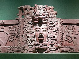
The Maya civilization of the Mesoamerican people is known by its ancient temples and glyphs. Its Maya script is the most sophisticated and highly developed writing system in the pre-Columbian Americas. It is also noted for its art, architecture, mathematics, calendar, and astronomical system.

El Tintal is a Maya archaeological site in the northern Petén region of Guatemala, about 25 kilometres (16 mi) northeast of the modern-day settlement of Carmelita, with settlement dating to the Preclassic and Classic periods. It is close to the better known sites of El Mirador, to which it was linked by causeway, and Nakbé. El Tintal is a sizeable site that includes some very large structures and it is one of the four largest sites in the northern Petén; it is the second largest site in the Mirador Basin, after El Mirador itself. El Tintal features monumental architecture dating to the Middle Preclassic similar to that found at El Mirador, Nakbé and Wakna. Potsherds recovered from the site date to the Late Preclassic and Early Classic periods, and construction continued at the site in the Late Classic period.

Potbelly sculptures are in-the-round sculptures of obese human figures carved from boulders. They are a distinctive element of the sculptural tradition in the southern Maya area of Mesoamerica. The precise purpose of potbelly sculptures is unknown, although they appear to have been the focus of public veneration and ritual directed by the ruling elite. Although this sculptural tradition is found within the southern Maya area, it has been recognized that the sculptures themselves are non-Maya.
Balberta is a major Mesoamerican archaeological site on the Pacific coastal plain of southern Guatemala, belonging to the Maya civilization. It has been dated to the Early Classic period and is the only known major site on the Guatemalan Pacific coastal plain to have exposed Early Classic architecture that has not been buried under posterior Late Classic construction. The site was related to the nearby site of San Antonio, which lies 6 kilometres (3.7 mi) to the west.
Punta de Chimino is a Maya archaeological site in the Petexbatún region of the department of Petén in Guatemala. Occupation at the site dates to the Preclassic and Classic periods of Mesoamerican chronology. Punta de Chimino experienced a population surge in the Late Preclassic, followed by a reduction in occupation levels in the Early Classic and another increase in the Terminal Classic when the city became one of the few population centres to survive the political disintegration of the Petexbatún region after the collapse of the kingdom based at Dos Pilas. The neighbouring city of Seibal on the Pasión River appears to have intervened at Punta de Chimino at this time and to have politically dominated the smaller site.

Sacul is an archaeological site of the Maya civilization located in the upper drainage of the Mopan River, in the Petén department of Guatemala. The city occupied an important trade route through the Maya Mountains. The main period of occupation dates to the Late Classic Period. In the late 8th century AD through to the early 9th century, Sacul was one of the few kingdoms in the southeastern Petén region to use its own Emblem Glyph, together with Ixtutz and Ucanal.
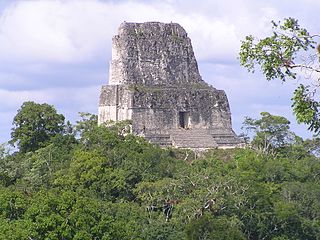
Tikal Temple IV is a Mesoamerican pyramid in the ruins of the ancient Maya city of Tikal in modern Guatemala. It was one of the tallest and most voluminous buildings in the Maya world. The pyramid was built around 741 AD. Temple IV is located at the western edge of the site core. Two causeways meet at the temple; the Tozzer Causeway runs east to the Great Plaza, while the Maudslay Causeway runs northeast to the Northern Zone. Temple IV is the second tallest pre-Columbian structure still standing in the New World, just after the Great Pyramid of Toniná in Chiapas, Mexico, although Teotihuacan's Pyramid of the Sun may once have been taller.

Ixtonton is a Maya archaeological site in the department of Petén in northern Guatemala. It is located in the northwestern portion of the Maya Mountains in the municipality of Dolores. The ruins are situated approximately 2 kilometres (1.2 mi) east of the town of Dolores itself. Ixtonton was the capital city of one of the four Maya kingdoms in the upper Mopan Valley. The site was occupied from the Late Preclassic period through to the Terminal Classic, with some evidence of continued activity into the Postclassic. For the majority of its history Ixtonton was the most important city in the upper Mopan Valley, with its only rivals emerging in the Late Classic. The acropolis at Ixtonton is laid out around two plazas on top of an artificially modified karstic hill.
The history of Maya civilization is divided into three principal periods: the Preclassic, Classic and Postclassic periods; these were preceded by the Archaic Period, which saw the first settled villages and early developments in agriculture. Modern scholars regard these periods as arbitrary divisions of chronology of the Maya civilization, rather than indicative of cultural evolution or decadence. Definitions of the start and end dates of period spans can vary by as much as a century, depending on the author. The Preclassic lasted from approximately 3000 BC to approximately 250 AD; this was followed by the Classic, from 250 AD to roughly 950 AD, then by the Postclassic, from 950 AD to the middle of the 16th century. Each period is further subdivided: