Related Research Articles
Copán is an archaeological site of the Maya civilization in the Copán Department of western Honduras, not far from the border with Guatemala. It is one of the most important sites of the Mayan civilization, which was not excavated until the 19th century. The ruined citadel and imposing public squares reveal the three main stages of development before the city was abandoned in the early 10th century.
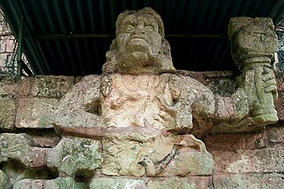
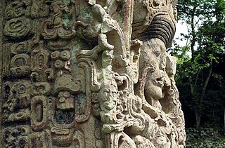
Kʼinich Yax Kʼukʼ Moʼ is named in Maya inscriptions as the founder and first ruler, kʼul ajaw, of the pre-Columbian Maya civilization polity centered at Copán, a major Maya site located in the southeastern Maya lowlands region in present-day Honduras. The motifs associated with his depiction on Copán monuments have a distinct resemblance to imagery associated with the height of the Classic-era center of Teotihuacan in the distant northern central Mexican region, and have been interpreted as intending to suggest his origins and association with that prestigious civilization. He is the founder of the Yax Kuk Mo Dynasty of rulers of Copan that lasted until 822 a.C. One of the most commonly cited motifs for this interpretation is the "goggle-eyed" headdress with which Yax Kʼukʼ Moʼ is commonly depicted; this is seemingly an allusion to the northern central Mexican rain deity known as Tlaloc by later peoples, such as the Aztecs. However, modern strontium isotope analysis of the human remains recovered from the tomb attributed to him indicate that Kʼinich Yax Kʼukʼ Moʼ spent his formative years much closer to Copán, at Tikal, and had not himself lived at Teotihuacan.
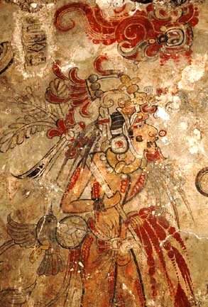
San Bartolo is a small pre-Columbian Maya archaeological site located in the Department of Petén in northern Guatemala, northeast of Tikal and roughly fifty miles from the nearest settlement. San Bartolo's fame derives from its splendid Late-Preclassic mural paintings still heavily influenced by Olmec tradition and from examples of early and as yet undecipherable Maya script.
Ixlu is a small Maya archaeological site that dates to the Classic and Postclassic Periods. It is located on the isthmus between the Petén Itzá and Salpetén lakes, in the northern Petén Department of Guatemala. The site was an important port with access to Lake Petén Itzá via the Ixlu River. The site has been identified as Saklamakhal, also spelt Saclemacal, a capital of the Kowoj Maya.

Tres Islas is a small pre-Columbian Maya archaeological site 20 kilometres (12 mi) north of Cancuen in Petén Department, northern Guatemala. The site has been dated to the Late Preclassic and Late Classic periods of Mesoamerican chronology. The main feature of the site is a group of three Maya stelae and an altar, arranged in a way that mimics an E-Group Maya astronomical complex.
La Joyanca is the modern name for a pre-Columbian Maya archaeological site located south of the San Pedro Martir river in the Petén department of Guatemala. It is east of the Maya site of La Florida (Namaan), now the modern town of El Naranjo on the Mexico-Guatemala border. The site was discovered in 1994 during the construction of the Xan-La Libertad oil pipeline in Guatemala. It was immediately recognized as an important, undiscovered Classic period Maya city and became the focus of an archaeological project. Directed by Charlotte Arnauld, Erik Ponciano, and Veronique Breuil, the La Joyanca project conducted excavations here between 1998 and 2003. Several members of this group have continued work at other related locations in the Northwest Peten, including the sites of Zapote Bobal and Pajaral, as part of the Proyecto Peten Noroccidente (PNO).
La Amelia is a Pre-Columbian Maya archaeological site near Itzan, in the lower Pasión River region of the Petén Department of Guatemala. It formed a polity in the Late Classic, and was involved in the war between Tikal and Calakmul followed, in 650, by La Amelia's takeover by Dos Pilas. Two centuries of intermittent warfare followed until the area's population was so diminished by about 830, that this is considered the beginning of abandonment of Classic sites in the region.

Yaxha is a Mesoamerican archaeological site in the northeast of the Petén Basin in modern-day Guatemala. As a ceremonial centre of the pre-Columbian Maya civilization, Yaxha was the third largest city in the region and experienced its maximum power during the Early Classic period.

Nakum is a Mesoamerican archaeological site, and a former ceremonial center and city of the pre-Columbian Maya civilization. It is located in the northeastern portion of the Petén Basin region, in the modern-day Guatemalan department of Petén. The northeastern Petén region contains a good number of other significant Maya sites, and Nakum is one of the three sites forming the Cultural Triangle of "Yaxha-Nakum-Naranjo". Nakum is approximately 17 kilometres (10.6 mi) to the north of Yaxha and some 25 kilometres (15.5 mi) to the east of Tikal, on the banks of the Holmul River. Its main features include an abundance of visibly restored architecture, and the roof comb of the site's main temple structure is one of the best-preserved outside Tikal.
Maya monarchs, also known as Maya kings and queens, were the centers of power for the Maya civilization. Each Maya city-state was controlled by a dynasty of kings. The position of king was usually inherited by the oldest son.
William Andrew "Bill" Saturno is an American archaeologist and Mayanist scholar who has made significant contributions toward the study of the pre-Columbian Maya civilization. Saturno is a former director of the Proyecto San Bartolo-Xultun at the Instito de Antropologia e Historia in Guatemala, a former national space research scientist at the Marshall Space Flight Center, and a research associate at the Peabody Museum at Harvard University. Saturno has previously worked as an Assistant Professor of Archaeology at Boston University and MIT and as a lecturer at the University of New Hampshire.
Bejucal is a Maya archaeological site in the Petén Department of Guatemala. It is located 7 kilometres (4.3 mi) northeast of El Zotz and was subservient to that city. The site is thought to date to the second half of the 4th century AD, in the Early Classic period.
Itzan is a Maya archaeological site located in the municipality of La Libertad in the Petén Department of Guatemala. Various small structures at the site were destroyed in the 1980s during oil exploration activities by Sonpetrol and Basic Resources Ltd, prompting rescue excavations by archaeologists. In spite of its small size, the site appears to have been the most politically important centre in its area, as evidenced by its unusually large quantity of monuments and the size of its major architecture.
Maya stelae are monuments that were fashioned by the Maya civilization of ancient Mesoamerica. They consist of tall, sculpted stone shafts and are often associated with low circular stones referred to as altars, although their actual function is uncertain. Many stelae were sculpted in low relief, although plain monuments are found throughout the Maya region. The sculpting of these monuments spread throughout the Maya area during the Classic Period, and these pairings of sculpted stelae and circular altars are considered a hallmark of Classic Maya civilization. The earliest dated stela to have been found in situ in the Maya lowlands was recovered from the great city of Tikal in Guatemala. During the Classic Period almost every Maya kingdom in the southern lowlands raised stelae in its ceremonial centre.

A twin-pyramid complex or twin-pyramid group was an architectural innovation of the Maya civilization of ancient Mesoamerica. Twin-pyramid complexes were regularly built at the great city of Tikal in the central Petén Basin of Guatemala to celebrate the end of the 20-year kʼatun cycle of the Maya Long Count Calendar. A twin-pyramid complex has been identified at Yaxha, a large city that was 30 kilometres (19 mi) to the southeast of Tikal. Another has been mapped at Ixlu, and Zacpeten appears also to possess at least one twin-pyramid complex and possibly two. These examples outside of Tikal itself indicate that their cities were closely linked to Tikal politically.
Juan Pedro Laporte Molina was a prominent Guatemalan archaeologist best known for his work on the ancient Maya civilization. He studied in the United States at the University of Arizona, in which he enrolled at the age of nineteen. After just one year he transferred to the Escuela Nacional de Antropología e Historia in Mexico. He continued his studies at the Universidad Autónoma de México from 1972 to 1976, from which he graduated with a doctorate in archaeology. He worked as a research assistant at the Museo Nacional de Antropología in Mexico City from 1967 through to 1976. Laporte worked at various archaeological sites while he was in Mexico, including Tlatilco, Chichen Itza and Dainzú. He first began working as an archaeologist in Guatemala in the 1970s, and was the head of the School of History of the Universidad de San Carlos de Guatemala (USAC) for more than thirty years. He first entered USAC in 1977, soon after returning from Mexico. In 1974 he carried out investigations at the Maya archaeological site of Uaxactun in the northern Petén Department of Guatemala. Between 1974 and 1976 he carried out archaeological investigations in Antigua Guatemala, which has since been designated as a UNESCO World Heritage Site, and around Lake Izabal.

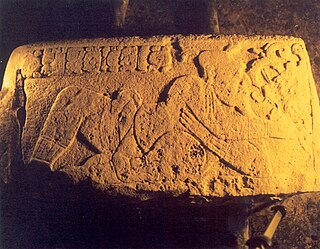
Dzibanche is an archaeological site of the ancient Maya civilization located in southern Quintana Roo, in the Yucatan Peninsula of southeastern Mexico. Dzibanche was a major Maya city and investigations in the first decade of the 21st century indicate that it was the early capital of the Kan dynasty, which later ruled from the great city of Calakmul. Dzibanche features the earliest known use of the Kaan dynasty emblem glyph.
The history of Maya civilization is divided into three principal periods: the Preclassic, Classic and Postclassic periods; these were preceded by the Archaic Period, which saw the first settled villages and early developments in agriculture. Modern scholars regard these periods as arbitrary divisions of chronology of the Maya civilization, rather than indicative of cultural evolution or decadence. Definitions of the start and end dates of period spans can vary by as much as a century, depending on the author. The Preclassic lasted from approximately 3000 BC to approximately 250 AD; this was followed by the Classic, from 250 AD to roughly 950 AD, then by the Postclassic, from 950 AD to the middle of the 16th century. Each period is further subdivided:

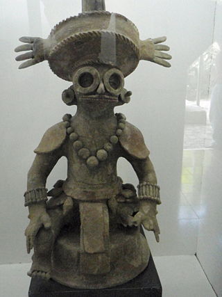
Yopaat was an important Maya storm god in the southern Maya area that included the cities of Copán and Quiriguá during the Classic period of Mesoamerican chronology. Yopaat was closely related to Chaac, the Maya rain god. Yopaat is depicted as bearing a flint weapon that represents a thunderbolt. Yopaat was held responsible for especially violent lightning storms, that were believed to cause earthquakes. He was often represented with a snake in place of one leg, demonstrating a close relationship with Kʼawiil, another Maya deity with similar attributes.

The Yax Kuk Mo dynasty was the royal house that reigned in the city-state of Copan (Oxwitik) for four centuries. This was installed in the city in the year 426 a.C, due to Teotihuacan influence and military support from the ruler Sihyaj Chan K'awiil II of Tikal, who ruled between the 5th and 9th centuries. The architectural works built in Copán during the rule of the Yax K'uk Mo' dynasty are preserved to this day, being accessible to the general public. Yax Kuk Mo In mayan means First Quetzal Macaw.
References
- 1 2 Vance, Eric (10 May 2012). "Unprecedented Maya Mural Found, Contradicts 2012 "Doomsday" Myth". National Geographic. Archived from the original on May 11, 2012. Retrieved 11 May 2012.
- ↑ "About". San Bartolo-Xultun (SBX). Retrieved 2022-06-22.
- ↑ "Team". San Bartolo-Xultun (SBX). Retrieved 2022-06-22.
- ↑ Saturno et al. 2017
- ↑ Zender and Skidmore 2012
- ↑ "No hint of world's end in oldest Mayan calendar". Australian Broadcasting Corporation. 11 May 2012. Archived from the original on 15 Sep 2018. Retrieved 11 May 2012.
- ↑ William A. Saturno; David Stuart; Anthony F. Aveni; Franco Rossi (11 May 2012). "Ancient Maya Astronomical Tables from Xultun, Guatemala". Science. 336 (6082): 714–717. Bibcode:2012Sci...336..714S. doi:10.1126/science.1221444. PMID 22582260.
- ↑ Saturno 2014
- ↑ Clarke 2013
- ↑ Prager et al. 2010
- ↑ Garrison and Stuart 2004; Rossi et al. 2015
- ↑ Garrison and Dunning 2009
- ↑ Krempel and Matteo 2012
