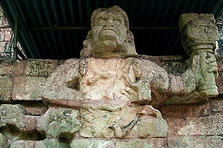
Copán is an archaeological site of the Maya civilization in the Copán Department of western Honduras, not far from the border with Guatemala. It is one of the most important sites of the Maya civilization, which was not excavated until the 19th century. The ruined citadel and imposing public squares reveal the three main stages of development before the city was abandoned in the early 10th century.
Dos Pilas is a Pre-Columbian site of the Maya civilization located in what is now the department of Petén, Guatemala. It dates to the Late Classic Period, and was founded by an offshoot of the dynasty of the great city of Tikal in AD 629 in order to control trade routes in the Petexbatún region, particularly the Pasión River. In AD 648 Dos Pilas broke away from Tikal and became a vassal state of Calakmul, although the first two kings of Dos Pilas continued to use the same emblem glyph that Tikal did. It was a predator state from the beginning, conquering Itzan, Arroyo de Piedra and Tamarindito. Dos Pilas and a nearby city, Aguateca, eventually became the twin capitals of a single ruling dynasty. The kingdom as a whole has been named as the Petexbatun Kingdom, after Lake Petexbatún, a body of water draining into the Pasión River.

Tikal is the ruin of an ancient city, which was likely to have been called Yax Mutal, found in a rainforest in Guatemala. It is one of the largest archeological sites and urban centers of the pre-Columbian Maya civilization. It is located in the archeological region of the Petén Basin in what is now northern Guatemala. Situated in the department of El Petén, the site is part of Guatemala's Tikal National Park and in 1979 it was declared a UNESCO World Heritage Site.

Quiriguá (Spanish pronunciation:[kiɾiˈɣwa]) is an ancient Maya archaeological site in the department of Izabal in south-eastern Guatemala. It is a medium-sized site covering approximately 3 square kilometres (1.2 sq mi) along the lower Motagua River, with the ceremonial center about 1 km (0.6 mi) from the north bank. During the Maya Classic Period (AD 200–900), Quiriguá was situated at the juncture of several important trade routes. The site was occupied by 200, construction on the acropolis had begun by about 550, and an explosion of grander construction started in the 8th century. All construction had halted by about 850, except for a brief period of reoccupation in the Early Postclassic (c. 900 – c. 1200). Quiriguá shares its architectural and sculptural styles with the nearby Classic Period city of Copán, with whose history it is closely entwined.

Tonina is a pre-Columbian archaeological site and ruined city of the Maya civilization located in what is now the Mexican state of Chiapas, some 13 km (8.1 mi) east of the town of Ocosingo.

Seibal, known as El Ceibal in Spanish, is a Classic Period archaeological site of the Maya civilization located in the northern Petén Department of Guatemala, about 100 km SW of Tikal. It was the largest city in the Pasión River region.

Naranjo is a Pre-Columbian Maya city in the Petén Basin region of Guatemala. It was occupied from about 500 BC to 950 AD, with its height in the Late Classic Period. The site is part of Yaxha-Nakum-Naranjo National Park. The city lies along the Mopan and Holmul rivers, and is about 50 km east of the site of Tikal. Naranjo has been the victim of severe looting. The site is known for its polychrome ceramic style.

Calakmul is a Maya archaeological site in the Mexican state of Campeche, deep in the jungles of the greater Petén Basin region. It is 35 kilometres (22 mi) from the Guatemalan border. Calakmul was one of the largest and most powerful ancient cities ever uncovered in the Maya lowlands.

Motul de San José is an ancient Maya site located just north of Lake Petén Itzá in the Petén Basin region of the southern Maya lowlands. It is a few kilometres from the modern village of San José, in Guatemala's northern department of Petén. A medium-sized civic-ceremonial centre, it was an important political and economic centre during the Late Classic period (AD 650–950).
Tres Islas is a small pre-Columbian Maya archaeological site 20 kilometres (12 mi) north of Cancuen in Petén Department, northern Guatemala. The site has been dated to the Late Preclassic and Late Classic periods of Mesoamerican chronology. The main feature of the site is a group of three Maya stelae and an altar, arranged in a way that mimics an E-Group Maya astronomical complex.

Ixkun is a pre-Columbian Maya archaeological site, situated in the Petén Basin region of the southern Maya lowlands. It lies to the north of the town of Dolores, in the modern-day department of Petén, Guatemala. It is a large site containing many unrestored mounds and ruins and is the best known archaeological site within the municipality of Dolores.

Ixtutz was an important Classic Period Maya city located south of Ixkun in southeastern Petén, Guatemala. Ixtutz is situated in the valley of the Poxte River in the western portion of the Maya Mountains. The site was inhabited during the Preclassic Period to the end of the Terminal Classic Period of Mesoamerican chronology and dominated the western portion of the Dolores valley.

El Zotz is a Mesoamerican archaeological site of the pre-Columbian Maya civilization, located in the Petén Basin region around 20 kilometres (12 mi) west of the major center of Tikal and approximately 26 kilometres (16 mi) west of Uaxactun. It is so called because of the large number of bats living in caves in the nearby cliffs. The site is located within the San Miguel la Palotada National Park bordering the Tikal National Park in the present-day department of Petén, Guatemala. It is a large Classic Period site and contains many unexcavated mounds and ruins.
La Joyanca is the modern name for a pre-Columbian Maya archaeological site located south of the San Pedro Martir river in the Petén department of Guatemala. It is east of the Maya site of La Florida (Namaan), now the modern town of El Naranjo on the Mexico-Guatemala border. The site was discovered in 1994 during the construction of the Xan-La Libertad oil pipeline in Guatemala. It was immediately recognized as an important, undiscovered Classic period Maya city and became the focus of an archaeological project. Directed by Charlotte Arnauld, Erik Ponciano, and Veronique Breuil, the La Joyanca project conducted excavations here between 1998 and 2003. Several members of this group have continued work at other related locations in the Northwest Peten, including the sites of Zapote Bobal and Pajaral, as part of the Proyecto Peten Noroccidente (PNO).

Yaxha is a Mesoamerican archaeological site in the northeast of the Petén Basin in modern-day Guatemala. As a ceremonial centre of the pre-Columbian Maya civilization, Yaxha was the third largest city in the region and experienced its maximum power during the Early Classic period.
Altar de Sacrificios is a ceremonial center and archaeological site of the pre-Columbian Maya civilization, situated near the confluence of the Pasión and Salinas Rivers, in the present-day department of Petén, Guatemala. Along with Seibal and Dos Pilas, Altar de Sacrificios is one of the better-known and most intensively-excavated sites in the region, although the site itself does not seem to have been a major political force in the Late Classic period.

Ian James Alastair Graham OBE was a British Mayanist whose explorations of Maya ruins in the jungles of Mexico, Guatemala, and Belize helped establish the Corpus of Maya Hieroglyphic Inscriptions published by the Peabody Museum of Harvard University. Among his related works is a biography of an early predecessor, the 19th-century British Maya explorer Alfred Maudslay.
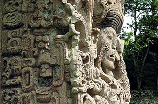
Maya stelae are monuments that were fashioned by the Maya civilization of ancient Mesoamerica. They consist of tall, sculpted stone shafts and are often associated with low circular stones referred to as altars, although their actual function is uncertain. Many stelae were sculpted in low relief, although plain monuments are found throughout the Maya region. The sculpting of these monuments spread throughout the Maya area during the Classic Period, and these pairings of sculpted stelae and circular altars are considered a hallmark of Classic Maya civilization. The earliest dated stela to have been found in situ in the Maya lowlands was recovered from the great city of Tikal in Guatemala. During the Classic Period almost every Maya kingdom in the southern lowlands raised stelae in its ceremonial centre.

Ixtonton is a Maya archaeological site in the department of Petén in northern Guatemala. It is located in the northwestern portion of the Maya Mountains in the municipality of Dolores. The ruins are situated approximately 2 kilometres (1.2 mi) east of the town of Dolores itself. Ixtonton was the capital city of one of the four Maya kingdoms in the upper Mopan Valley. The site was occupied from the Late Preclassic period through to the Terminal Classic, with some evidence of continued activity into the Postclassic. For the majority of its history Ixtonton was the most important city in the upper Mopan Valley, with its only rivals emerging in the Late Classic. The acropolis at Ixtonton is laid out around two plazas on top of an artificially modified karstic hill.

A twin-pyramid complex or twin-pyramid group was an architectural innovation of the Maya civilization of ancient Mesoamerica. Twin-pyramid complexes were regularly built at the great city of Tikal in the central Petén Basin of Guatemala to celebrate the end of the 20-year kʼatun cycle of the Maya Long Count Calendar. A twin-pyramid complex has been identified at Yaxha, a large city that was 30 kilometres (19 mi) to the southeast of Tikal. Another has been mapped at Ixlu, and Zacpeten appears also to possess at least one twin-pyramid complex and possibly two. These examples outside of Tikal itself indicate that their cities were closely linked to Tikal politically.

