Altun Ha is the name given to the ruins of an ancient Maya city in Belize, located in the Belize District about 50 kilometres (31 mi) north of Belize City and about 10 kilometres (6.2 mi) west of the shore of the Caribbean Sea. The site covers an area of about 8 square kilometres (3.1 sq mi).

Nim Li Punit is a Maya Classic Period site in the Toledo District of the nation of Belize, located 50 kilometres north of the town of Punta Gorda, and directly adjacent to the village of Indian Creek. Nim Li Punit is sometimes known as Big Hat or Top Hat; the name is Kekchi Maya for "Big Hat", referring to the large elaborate head-dress on a stela sculpture found on site depicting one of the site's ancient kings. It is bordered by the Maya Mountains to the west and lowland swamps and the Caribbean Sea to the east.

The Maya Mountains are a mountain range located in Belize and eastern Guatemala, in Central America.

The Madrid Codex is one of four surviving pre-Columbian Maya books dating to the Postclassic period of Mesoamerican chronology. The Madrid Codex was produced in western Yucatán, Mexico, today is held by the Museo de América in Madrid and is considered to be the most important piece in its collection. However, the original is not on display due to its fragility; an accurate reproduction is displayed in its stead. At one point in time the codex was split into two pieces, given the names "Codex Troano" and "Codex Cortesianus". In the 1880s, Leon de Rosny, an ethnologist, realised that the two pieces belonged together, and helped combine them into a single text. This text was subsequently brought to Madrid, and given the name "Madrid Codex", which remains its most common name today.

Maya codices are folding books written by the pre-Columbian Maya civilization in Maya hieroglyphic script on Mesoamerican bark paper. The folding books are the products of professional scribes working under the patronage of deities such as the Tonsured Maize God and the Howler Monkey Gods. The codices have been named for the cities where they eventually settled. The Dresden Codex is generally considered the most important of the few that survive.

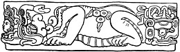
K’uk’ulkan, also spelled Kukulkan, is the serpent deity of Maya mythology. It is closely related to the deity Qʼuqʼumatz of the Kʼicheʼ people and to Quetzalcoatl of Aztec mythology. Prominent temples to Kukulkan are found at archaeological sites in the Yucatán Peninsula, such as Chichen Itza, Uxmal and Mayapan.
The Petén Basin is a geographical subregion of the Maya Lowlands, primarily located in northern Guatemala within the Department of El Petén, and into the state of Campeche in southeastern Mexico.
Ixlu is a small Maya archaeological site that dates to the Classic and Postclassic Periods. It is located on the isthmus between the Petén Itzá and Salpetén lakes, in the northern Petén Department of Guatemala. The site was an important port with access to Lake Petén Itzá via the Ixlu River. The site has been identified as Saklamakhal, also spelt Saclemacal, a capital of the Kowoj Maya.
Kinal is a major pre-Columbian Maya archaeological site in the Petén Department of the modern-day Petén Department of northern Guatemala. The major occupational phase for the site dates from the Late Classic period of Mesoamerican chronology, with evidence for a substantial and expansionary building program dating from the first half of the 8th century AD. Kinal was discovered in the 1960s by archaeologist Ian Graham while he was carrying out an archaeological survey of the region, although no excavations were undertaken at the site at that time.

Nakum is a Mesoamerican archaeological site, and a former ceremonial center and city of the pre-Columbian Maya civilization. It is located in the northeastern portion of the Petén Basin region, in the modern-day Guatemalan department of Petén. The northeastern Petén region contains a good number of other significant Maya sites, and Nakum is one of the three sites forming the Cultural Triangle of "Yaxha-Nakum-Naranjo". Nakum is approximately 17 kilometres (10.6 mi) to the north of Yaxha and some 25 kilometres (15.5 mi) to the east of Tikal, on the banks of the Holmul River. Its main features include an abundance of visibly restored architecture, and the roof comb of the site's main temple structure is one of the best-preserved outside Tikal.

Uxbenka is a pre-Columbian Mesoamerican archaeological site located in Belize's southernmost district of Toledo. An urban settlement of the pre-Columbian Maya, it is the earliest-known Maya polity in the southern Belizean lowlands, with evidence of occupation dating to the Early Classic period of Mesoamerican chronology.
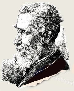
Eduard Georg Seler was a prominent German anthropologist, ethnohistorian, linguist, epigrapher, academic and Americanist scholar, who made extensive contributions in these fields towards the study of pre-Columbian era cultures in the Americas.
The San Estevan archaeological site is located in northern Belize 1 km from the modern community of San Estevan, Belize. The site is a Maya civilization site occupied during the Formative and Classic eras of Mesoamerican chronology. San Estevan is located on the New River halfway between the sites of Cerros and Lamanai. Beginning in the Late Formative period, San Estevan was a regional political center.
Simon Martin is a British epigrapher, historian, writer and Mayanist scholar. He is best known for his contributions to the study and decipherment of the Maya script, the writing system used by the pre-Columbian Maya civilisation of Mesoamerica. As one of the leading epigraphers active in contemporary Mayanist research, Martin has specialised in the study of the political interactions and dynastic histories of Classic-era Maya polities. Since 2003 Martin has held positions at the University of Pennsylvania Museum of Archaeology and Anthropology where he is currently an Associate Curator and Keeper in the American Section, while teaching select courses as an Adjunct Associate Professor in the Department of Anthropology at the University of Pennsylvania.
Holmul is a pre-Columbian archaeological site of the Maya civilization located in the northeastern Petén Basin region in Guatemala near the modern-day border with Belize.
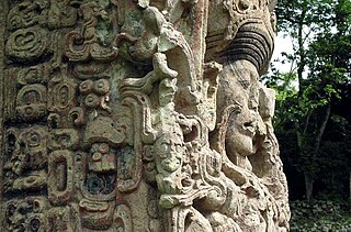
Maya stelae are monuments that were fashioned by the Maya civilization of ancient Mesoamerica. They consist of tall, sculpted stone shafts and are often associated with low circular stones referred to as altars, although their actual function is uncertain. Many stelae were sculpted in low relief, although plain monuments are found throughout the Maya region. The sculpting of these monuments spread throughout the Maya area during the Classic Period, and these pairings of sculpted stelae and circular altars are considered a hallmark of Classic Maya civilization. The earliest dated stela to have been found in situ in the Maya lowlands was recovered from the great city of Tikal in Guatemala. During the Classic Period almost every Maya kingdom in the southern lowlands raised stelae in its ceremonial centre.
Pusilhá is an archaeological site in Belize. The location of this Late Classic Maya urban complex, along the east and west flow of trade, made the city a major transfer point for economic activities in the whole region. In addition, the city gave archaeologists a historical view of a secondary Maya site. Large and extended excavation efforts have changed the overall picture of Maya social and political relationships between larger and smaller cities and challenged the prevailing view of conquest and absorption of smaller cities into the larger cities in the region. The research conducted at Pusilhá began in 1927 and continues to this day.

The extensive trade networks of the Ancient Maya contributed largely to the success of their civilization spanning three millennia. Maya royal control and the wide distribution of foreign and domestic commodities for both population sustenance and social affluence are hallmarks of the Maya visible throughout much of the iconography found in the archaeological record. In particular, moderately long-distance trade of foreign commodities from the Caribbean and Gulf Coasts provided the larger inland Maya cities with the resources they needed to sustain settled population levels in the several thousands. Though the ruling class essentially controlled the trade economy, a middle merchant class supervised import and export from cities and trade ports. Not much is known of the Maya merchant class; however, merchants of royal lineage are sometimes represented in the iconography. Notably, a canoe paddle often accompanies the royal merchant depictions, signifying their association with marine resources.

The Manche Chʼol were a Maya people who constituted the former Manche Chʼol Territory, a Postclassic polity of the southern Maya Lowlands, within the extreme south of what is now Petén and the area around Lake Izabal in northern Guatemala, and southern Belize. The Manche Chʼol took the name Manche from the name of their main settlement. They were the last of a set of Ch'olan-speaking groups in the eastern Maya Lowlands to remain independent and ethnically distinct. It is likely that they were descended from the inhabitants of Classic period Maya cities in the southeastern Maya Lowlands, such as Nim Li Punit, Copán and Quiriguá.