Tikal is the ruin of an ancient city, which was likely to have been called Yax Mutal, found in a rainforest in Guatemala. It is one of the largest archeological sites and urban centers of the pre-Columbian Maya civilization. It is located in the archeological region of the Petén Basin in what is now northern Guatemala. Situated in Petén Department, the site is part of Guatemala's Tikal National Park and in 1979 it was declared a UNESCO World Heritage Site.

Becan is an archaeological site of the Maya civilization in pre-Columbian Mesoamerica. Becan is located near the center of the Yucatán Peninsula, in the present-day Mexican state of Campeche, about 150 km (93.2 mi) north of Tikal. The Maya sites of Balamku, Calakmul, Chicanna and Xpuhil are nearby. The name Becan was bestowed on the site by archaeologists who rediscovered the site, meaning "ravine or canyon formed by water" in Yukatek Maya, after the site's most prominent and unusual feature, its surrounding ditch.

Chacchoben is a Maya ruin approximately 110 mi (177 km) south of Tulum and 7 mi (11 km) from the village from which it derives its name.
The Mayan architecture of the Maya civilization spans across several thousands of years, several eras of political change, and architectural innovation before the Spanish colonization of the Americas. Often, the buildings most dramatic and easily recognizable as creations of the Maya peoples are the step pyramids of the Terminal Preclassic Maya period and beyond. Based in general Mesoamerican architectural traditions, the Maya utilized geometric proportions and intricate carving to build everything from simple houses to ornate temples. This article focuses on the more well-known pre-classic and classic examples of Maya architecture. The temples like the ones at Palenque, Tikal, and Uxmal represent a zenith of Maya art and architecture. Through the observation of numerous elements and stylistic distinctions, remnants of Maya architecture have become an important key to understanding their religious beliefs and culture as a whole.

The Maya Biosphere Reserve is a nature reserve in Guatemala managed by Guatemala's National Council of Protected Areas (CONAP). The Maya Biosphere Reserve covers an area of 21,602 km2, one-fifth of the country's total land area.

El Zotz is a Mesoamerican archaeological site of the pre-Columbian Maya civilization, located in the Petén Basin region around 20 kilometres (12 mi) west of the major center of Tikal and approximately 26 kilometres (16 mi) west of Uaxactun. It is so called because of the large number of bats living in caves in the nearby cliffs. The site is located within the San Miguel la Palotada National Park bordering the Tikal National Park in the present-day department of Petén, Guatemala. It is a large Classic Period site and contains many unexcavated mounds and ruins.

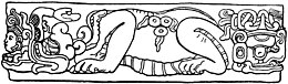
Chicanná was a Maya city that was built during the Classic period. The site was named after its most famous building, Structure II, which means "House of the Serpent Mouth" in Maya. In the Maya language chi means "mouth", can means "serpent" and na means "house". The site is located two kilometers west of Becán in Calakmul Biosphere Reserve of the Mexican state of Campeche on the Yucatán Peninsula. It is one of 45 other ruin sites located within that area.
Xpujil is a town in the Mexican state of Campeche. It serves as the municipal seat for the surrounding municipality of Calakmul. As of 2010, Xpujil had a population of 3,984.

Xpuhil Pronounced:/ʃpuχil̥/ is a Maya archaeological site located in the Mexican state of Campeche, in the vicinity of the modern-day town of Xpujil. The area surrounding Xpuhil inside the Calakmul Biosphere Reserve, along Federal Highway 186, is rich with other Maya sites, including Becan, Chicanná and Calakmul. The name xpuhil means "cat's tail" in reference to a type of vegetation found locally.

Chichén Itzá was a large pre-Columbian city built by the Maya people of the Terminal Classic period. The archeological site is located in Tinúm Municipality, Yucatán State, Mexico.
Remote sensing techniques in archaeology are an increasingly important component of the technical and methodological tool set available in archaeological research. The use of remote sensing techniques allows archaeologists to uncover unique data that is unobtainable using traditional archaeological excavation techniques.
Chactún is the name of an archaeological site of the Mesoamerican Maya civilization in the state of Campeche, Mexico, in the northern part of the Calakmul Biosphere Reserve. The site of approximately 54 acres (22 ha) is located in the lowlands of the Yucatán Peninsula, between the regions of Rio Bec and Chenes. There are some significant differences that have yet to be explained completely, which distinguish it from some of the other nearby sites.
Balamku is a small Maya archaeological site located in the Mexican state of Campeche. It features elaborate plaster facades dating to the Early Classic period. It has one of the largest surviving stucco friezes in the Maya world. Balamku was first occupied from around 300 BC. Its most important buildings date from AD 300–600.

Maya cities were the centres of population of the pre-Columbian Maya civilization of Mesoamerica. They served the specialised roles of administration, commerce, manufacturing and religion that characterised ancient cities worldwide. Maya cities tended to be more dispersed than cities in other societies, even within Mesoamerica, as a result of adaptation to a lowland tropical environment that allowed food production amidst areas dedicated to other activities. They lacked the grid plans of the highland cities of central Mexico, such as Teotihuacán and Tenochtitlan. Maya kings ruled their kingdoms from palaces that were situated within the centre of their cities. Cities tended to be located in places that controlled trade routes or that could supply essential products. This allowed the elites that controlled trade to increase their wealth and status. Such cities were able to construct temples for public ceremonies, thus attracting further inhabitants to the city. Those cities that had favourable conditions for food production, combined with access to trade routes, were likely to develop into the capital cities of early Maya states.
Kʼàakʼ Chiʼ is a hypothetical archaeological site of the pre-Columbian Maya civilization, proposed by then 15-year old William Gadoury of Saint-Jean-de-Matha, Quebec in 2016. It is located in the state of Campeche in southern Mexico, in the extreme south of the Yucatán Peninsula. The location was determined by overlaying Maya constellations with a map of the Yucatán Peninsula.

Aguada Fénix is a large Preclassic Mayan ruin located in the state of Tabasco, Mexico, near the border with Guatemala. It was discovered by aerial survey using laser mapping and announced in 2020. The flattened mound is 1,400 m long and is described as the oldest and the largest Mayan ceremonial site known. The monumental structure is constructed of earth and clay, and is believed to have been built from around 1000 BC to 800 BC. It is also believed to have been abandoned in around 750 BC, shortly after its completion in roughly 800 BC.
Ocomtún is an ancient Late Classic city located on the Yucatan Peninsula in the Mexican state of Campeche. Archaeologists from Mexico's National Institute of Anthropology and History announced the discovery of the city in June 2023, after finding the ruins of several pyramid structures measuring approximately 15 m in height in a relatively unexplored area of the state. Analysis of pottery fragments found in the area indicate the area was inhabited by the Maya people between 600 CE and 800 CE, and that the city fell into ruin in around 1000 CE, coinciding with the Classic Maya collapse. Archaeologists named the site Ocomtún after the Mayan word for stone column.
Nadzca'an is a Maya archaeological site located in the Balam Kú Biosphere Reserve of Campeche in Mexico. Nadzca'an was a classical period Maya city and ceremonial center built over an artificial plateau. It is located approximately 12 km northeast of the Maya site of Balamku. Numerous stelas have been found inside the main structures of the site, a mention to the emblem glyph of Calakmul is found carved on a monument from Nadzca'an.

Noh Kah is an ancient Maya city and archaeological site located in the jungle of southern Quintana Roo in Mexico. Noh Kah developed during the early and late Classic period of the Maya civilization, around the years 200 to 900 AD and was a large Maya settlement near the region dominated by the Kaan dynasty of Dzibanche in southern Quintana Roo.

Itzamkanac, also known as El Tigre, is an ancient Pre-Columbian city and archaeological Maya site located in the municipality of Candelaria in the state of Campeche, Mexico. Itzamkanac was the capital of the pre-Hispanic Acalan province ruled by the Chontal Maya or Putún Maya until the arrival and encounter with the Spanish conquistadors.