La Joyanca

Last updated

La Joyanca is the modern name for a pre-Columbian Maya archaeological site located south of the San Pedro Martir river in the Petén department of Guatemala. It is east of the Maya site of La Florida (Namaan), now the modern town of El Naranjo on the Mexico-Guatemala border. The site was discovered in 1994 during the construction of the Xan-La Libertad oil pipeline in Guatemala. It was immediately recognized as an important, undiscovered Classic period (AD 200-900) Maya city and became the focus of an archaeological project. Directed by Charlotte Arnauld, Erik Ponciano, and Veronique Breuil, the La Joyanca project conducted excavations here between 1998 and 2003. Several members of this group have continued work at other related locations in the Northwest Peten, including the sites of Zapote Bobal and Pajaral, as part of the Proyecto Peten Noroccidente (PNO).

Maya civilization Mesoamerican civilization

The Maya civilization was a Mesoamerican civilization developed by the Maya peoples, and noted for its logosyllabic script—the most sophisticated and highly developed writing system in pre-Columbian Americas—as well as for its art, architecture, mathematics, calendar, and astronomical system. The Maya civilization developed in an area that encompasses southeastern Mexico, all of Guatemala and Belize, and the western portions of Honduras and El Salvador. This region consists of the northern lowlands encompassing the Yucatán Peninsula, and the highlands of the Sierra Madre, running from the Mexican state of Chiapas, across southern Guatemala and onwards into El Salvador, and the southern lowlands of the Pacific littoral plain.

Archaeological site Place in which evidence of past activity is preserved

An archaeological site is a place in which evidence of past activity is preserved, and which has been, or may be, investigated using the discipline of archaeology and represents a part of the archaeological record. Sites may range from those with few or no remains visible above ground, to buildings and other structures still in use.

Guatemala Republic in Central America

Guatemala, officially the Republic of Guatemala, is a country in Central America bordered by Mexico to the north and west, Belize and the Caribbean to the northeast, Honduras to the east, El Salvador to the southeast and the Pacific Ocean to the south. With an estimated population of around 16.6 million, it is the most populated country in Central America. Guatemala is a representative democracy; its capital and largest city is Nueva Guatemala de la Asunción, also known as Guatemala City.

Archaeology

La Joyanca was occupied for well over 1000 years. Dates from the site range from the Late Preclassic (200 BC) to the Terminal Classic/Postclassic (AD 1000). Population levels reached their height here during the Late Classic (AD 600-900); during this era the rulers of La Joyanca embarked upon an ambitious building project in two areas, dubbed the Plaza Principal and the Grupo Guacamaya. The Grupo Guacamaya, a complex of vaulted rooms and corridors, may have served as their palace and thus the seat of local government. Following this prosperous era, the site, like most of its Classic period contemporaries, underwent a dramatic collapse. The Grupo Guacamaya was briefly occupied by squatters in the 10th century, but the area was ultimately abandoned by AD 1000.

A government is the system or group of people governing an organized community, often a state.

The central portion of La Joyanca includes several temple-pyramids and other mounds. The two tallest of these, situated in the Plaza Principal, are 10 and 12 meters high (Str. 6E and 6E-12, respectively). Several of these have been restored, including Structure 6E-12, which contains several vaulted rooms, the remains of hieroglyphic inscriptions, and a stuccoed image of K'inich Ajaw , the Classic Maya sun god. Also noteworthy among the central buildings is Structure 6E-13, which has several rooms atop a platform 6 meters high and 56 meters long.

Hieroglyph Pictographic sign

A hieroglyph was a character of the ancient Egyptian writing system. Logographic scripts that are pictographic in form in a way reminiscent of ancient Egyptian are also sometimes called "hieroglyphs". In Neoplatonism, especially during the Renaissance, a "hieroglyph" was an artistic representation of an esoteric idea, which Neoplatonists believed actual Egyptian hieroglyphs to be. The word hieroglyphics refer to a hieroglyphic script.

Stucco material made of aggregates, a binder, and water

Stucco or render is a material made of aggregates, a binder, and water. Stucco is applied wet and hardens to a very dense solid. It is used as a decorative coating for walls and ceilings, and as a sculptural and artistic material in architecture. Stucco may be used to cover less visually appealing construction materials, such as metal, concrete, cinder block, or clay brick and adobe.

Although the Grupo Guacamaya seems to be a palace, La Joyanca lacks the clearly identifiable center characteristic of most archaeological sites in the central Petén. There are few sculpted monuments, no ballcourt, and scant signs of a strong, centralized royal dynasty comparable to those functioning at ancient Maya sites like El Peru or Tikal. Likewise, settlement in the area seems to have fluctuated, with longstanding occupied areas standing in stark contrast to communities like the small Gavilán Group, which seems to have been occupied for scarcely a generation.

Palace grand residence, especially a royal residence or the home of a head of state

A palace is a grand residence, especially a royal residence, or the home of a head of state or some other high-ranking dignitary, such as a bishop or archbishop.

The Petén Basin is a geographical subregion of Mesoamerica, primarily located in northern Guatemala within the Department of El Petén, and into Campeche state in southeastern Mexico.

Monument type of structure either explicitly created to commemorate a person or important event, or used for that purpose

A monument is a type of—usually three-dimensional—structure that was explicitly created to commemorate a person or event, or which has become relevant to a social group as a part of their remembrance of historic times or cultural heritage, due to its artistic, historical, political, technical or architectural importance. Examples of monuments include statues, (war) memorials, historical buildings, archaeological sites, and cultural assets. If there is a public interest in its preservation, a monument can for example be listed as a UNESCO World Heritage Site.

While the names of the elites who ruled La Joyanca are largely absent from the archaeological record, epigrapher David Stuart, of the University of Texas, has recently demonstrated that an individual bearing the name Chan Ahk or "Sky/Serpent Turtle", an appellation found at the neighboring sites of Zapote Bobal and Pajaral, appears on La Joyanca Stela 1 (dated to AD 485). This suggests that all three sites were related during the Classic Period (AD 200-900) and that they possibly formed a political unit, each site waxing and waning in power over time.

Elite group or class of persons enjoying superior intellectual or social or economic status

In political and sociological theory, the elite are a small group of powerful people who hold a disproportionate amount of wealth, privilege, political power, or skill in a society. Defined by the Cambridge Dictionary, the "elite" are "those people or organizations that are considered the best or most powerful compared to others of a similar type."

The archaeological record is the body of physical evidence about the past. It is one of the core concepts in archaeology, the academic discipline concerned with documenting and interpreting the archaeological record. Archaeological theory is used to interpret the archaeological record for a better understanding of human cultures. The archaeological record can consist of the earliest ancient findings as well as contemporary artifacts. Human activity has had a large impact on the archaeological record. Destructive human processes, such as agriculture and land development, may damage or destroy potential archaeological sites. Other threats to the archaeological record include natural phenomena and scavenging. Archaeology can be a destructive science for the finite resources of the archaeological record are lost to excavation. Therefore, archaeologists limit the amount of excavation that they do at each site and keep meticulous records of what is found. The archaeological record is the physical record of human prehistory and history, of why ancient civilizations prospered or failed and why those cultures changed and grew. It is the story of the human world.

Zapote Bobal

Zapote Bobal is the modern name for a pre-Columbian Maya archaeological site located south of the San Pedro Martir river in the Petén department of Guatemala. The name Zapote Bobal was coined by archaeologist Ian Graham, who discovered the site in the 1970s. It refers to the large number of Zapote Bobo trees, which grow near abundant sources of water in the Petén Basin. The site languished in archaeological obscurity until 2003, when epigrapher David Stuart connected the archaeological site of Zapote Bobal with a name repeatedly mentioned in the inscriptions of sites like Piedras Negras and Yaxchilan. That name was the toponym Hix Witz, or "Jaguar Hill" Scholars had recognized this name for over 20 years, and its connection to a real place prompted the creation of an archaeological project at Zapote Bobal in 2003, the Proyecto Peten Noroccidente (PNO). It is currently directed by James Fitzsimmons and Laura Gamez.

Related Research Articles

San Andrés, El Salvador

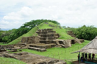
San Andrés is a pre-Columbian site in El Salvador, whose occupation began around the year 900 BC as an agricultural town in the valley of Zapotitán in the department of La Libertad. This early establishment was vacated by the year 250 because of the enormous eruption of the caldera of Lago Ilopango, and was occupied again in the 5th Century, along with many other sites in the valley of Zapotitán. Between 600 and 900 AD, San Andrés was the capital of a Maya polity with supremacy over the other establishments of Valle de Zapotitán.

Tikal Temple I

Tikal Temple I is the designation given to one of the major structures at Tikal, one of the largest cities and archaeological sites of the pre-Columbian Maya civilization in Mesoamerica. It is located in the Petén Basin region of northern Guatemala. It also is known as the Temple of the Great Jaguar because of a lintel that represents a king sitting upon a jaguar throne. An alternative name is the Temple of Ah Cacao, after the ruler buried in the temple. Temple I is a typically Petén-styled limestone stepped pyramid structure that is dated to approximately 732 AD.

Ixlu

Ixlu is a small Maya archaeological site that dates to the Classic and Postclassic Periods. It is located on the isthmus between the Petén Itzá and Salpetén lakes, in the northern Petén Department of Guatemala. The site was an important port with access to Lake Petén Itzá via the Ixlu River. The site has been identified as Saklamakhal, also spelt Saclemacal, a capital of the Kowoj Maya.

Pajaral

Pajaral, otherwise known as El Pajaral, is the modern name for a mid-sized ruined city of the pre-Columbian Maya archaeological site located to the south of the San Pedro Martir river in the Petén department of Guatemala. The name El Pajaral was coined by archaeologist Ian Graham, who discovered the site in the 1970s, and refers to the numerous birds he encountered there during his survey.

Tamarindito

Tamarindito is an archaeological site of the Maya civilization located along an escarpment in the Petén department of Guatemala. The city was the capital of the Petexbatún region of the southwestern Petén during the Early Classic period but was displaced by the newly founded conquest state of Dos Pilas. In the 8th century Tamarindito turned on its new overlord and defeated it. After the destruction of the Dos Pilas kingdom the region descended into chaos and suffered rapid population decline. The city was all but abandoned by the 9th century AD.

Ixkun archaeological Maya site in Guatemala‎

Ixkun is a pre-Columbian Maya archaeological site, situated in the Petén Basin region of the southern Maya lowlands. It lies to the north of the town of Dolores, in the modern-day department of Petén, Guatemala. It is a large site containing many unrestored mounds and ruins and is the best known archaeological site within the municipality of Dolores.

Kinal

Kinal is a major pre-Columbian Maya archaeological site in the Petén Department of the modern-day Petén Department of northern Guatemala. The major occupational phase for the site dates from the Late Classic period of Mesoamerican chronology, with evidence for a substantial and expansionary building program dating from the first half of the 8th century AD. Kinal was discovered in the 1960s by archaeologist Ian Graham while he was carrying out an archaeological survey of the region, although no excavations were undertaken at the site at that time.

Topoxte island

Topoxte is a pre-Columbian Maya archaeological site in the Petén Basin in northern Guatemala with a long occupational history dating as far back as the Middle Preclassic. As the capital of the Kowoj Maya, it was the largest of the few Postclassic Mesoamerican sites in the area. Topoxte is located on an island on Yaxha Lake across from the important Classic period center of Yaxha.

Zacpeten

Zacpeten is a pre-Columbian Maya archaeological site in the northern Petén Department of Guatemala. It is notable as one of the few Maya communities that maintained their independence through the early phases of Spanish control over Mesoamerica.

Yaxha archaeological site

Yaxha is a Mesoamerican archaeological site in the northeast of the Petén Basin region, and a former ceremonial centre and city of the pre-Columbian Maya civilization. Yaxha was the third largest city in the region and experienced its maximum power during the Early Classic period.

Altar de Sacrificios

Altar de Sacrificios is a ceremonial center and archaeological site of the pre-Columbian Maya civilization, situated near the confluence of the Pasión and Salinas Rivers, in the present-day department of Petén, Guatemala. Along with Seibal and Dos Pilas, Altar de Sacrificios is one of the better-known and most intensively-excavated sites in the region, although the site itself does not seem to have been a major political force in the Late Classic period.

El Puente, or the Parque Arqueológico El Puente, is a Maya archaeological site in the department of Copán in Honduras. Once an independent Maya city, the city of El Puente became a tributary to the nearby city of Copán between the 6th and 9th centuries AD. The site contains more than 200 structures that include tombs, religious structures, and living quarters, but only a few have been excavated, including a large Maya step pyramid.

Balamku

Balamku is a small Maya archaeological site located in the Mexican state of Campeche. It features elaborate plaster facades dating to the Early Classic period. It has one of the largest surviving stucco friezes in the Maya world. Balamku was first occupied from around 300 BC. Its most important buildings date from AD 300–600.

Itzan

Itzan is a Maya archaeological site located in the municipality of La Libertad in the Petén Department of Guatemala. Various small structures at the site were destroyed in the 1980s during oil exploration activities by Sonpetrol and Basic Resources Ltd, prompting rescue excavations by archaeologists. In spite of its small size, the site appears to have been the most politically important centre in its area, as evidenced by its unusually large quantity of monuments and the size of its major architecture.

Preclassic Maya

The Preclassic period in Maya history stretches from the beginning of permanent village life c. 1000 BC. until the advent of the Classic Period c. 250 AD, and is subdivided into Early, Middle, and Late. Major archaeological sites of this period include Nakbe, Uaxactun, Seibal, San Bartolo, Cival, and El Mirador in Guatemala; Cahal Pech, Blackman Eddy, and Cerros in Belize; and Calakmul, Yaxnohcah, Ichkabal, Komchen, and Xocnaceh in Mexico.

La Blanca, Peten archaeological site in Petén, Guatemala

La Blanca is a Maya archaeological site in the municipality of Melchor de Mencos in the northern Petén Department of Guatemala. The site is located in the lower reaches of the Mopan River valley and features a large acropolis complex. Activity at the site has been dated as far back as the Early Classic, with principal occupation of the site occurring in the Late Classic period, although some level of occupation continued into the Early Postclassic.

Yalain

The Yalain have been proposed as a Maya polity that existed during the Postclassic period in the Petén Basin of northern Guatemala, based in the central Petén lakes region. A small town called Yalain was described in 1696 by the Franciscan friar Andrés de Avendaño y Loyola. It was said to consist of a relatively small number of residences clustered within rich agricultural land. The town was located to the east of Lake Petén Itzá and was said to have been farmed by the inhabitants of Nojpetén, the capital city of the Itza kingdom. The political extent and archaeology of the Yalain is poorly understood.

Salinas de los Nueve Cerros is an archaeological site located in west-central Guatemala. It is the only Precolumbian salt works in the Maya lowlands and one of the longest-occupied sites in Guatemala.

References

International Standard Book Number Unique numeric book identifier

The International Standard Book Number (ISBN) is a numeric commercial book identifier which is intended to be unique. Publishers purchase ISBNs from an affiliate of the International ISBN Agency.