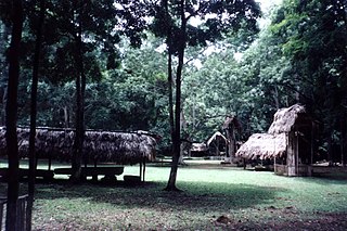
Dos Pilas is a Pre-Columbian site of the Maya civilization located in what is now the department of Petén, Guatemala. It dates to the Late Classic Period, being founded by an offshoot of the dynasty of the great city of Tikal in AD 629 in order to control trade routes in the Petexbatún region, particularly the Pasión River. In AD 648 Dos Pilas broke away from Tikal and became a vassal state of Calakmul, although the first two kings of Dos Pilas continued to use the same emblem glyph that Tikal did. It was a predator state from the beginning, conquering Itzan, Arroyo de Piedra and Tamarindito. Dos Pilas and a nearby city, Aguateca, eventually became the twin capitals of a single ruling dynasty. The kingdom as a whole has been named as the Petexbatun Kingdom, after Lake Petexbatún, a body of water draining into the Pasión River.
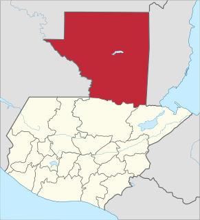
Petén is a department of the Republic of Guatemala. It is geographically the northernmost department of Guatemala, as well as the largest by area — at 35,854 km2 (13,843 sq mi) it accounts for about one third of Guatemala's area. The capital is Flores. The population at the 2018 census was 545,600.

Piedras Negras is the modern name for a ruined city of the pre-Columbian Maya civilization located on the north bank of the Usumacinta River in the Petén department of northeastern Guatemala. Piedras Negras is one of the most powerful of the Usumacinta ancient Maya urban centers. Occupation at Piedras Negras is known from the Late Preclassic period onward, based on dates retrieved from epigraphic information found on multiple stelae and altars at the site. Piedras Negras is an archaeological site known for its large sculptural output when compared to other ancient Maya sites. The wealth of sculpture, in conjunction with the precise chronological information associated with the lives of elites of Piedras Negras, has allowed archaeologists to reconstruct the political history of the Piedras Negras polity and its geopolitical footprint.

Seibal, known as El Ceibal in Spanish, is a Classic Period archaeological site of the Maya civilization located in the northern Petén Department of Guatemala, about 100 km SW of Tikal. It was the largest city in the Pasión River region.

Motul de San José is an ancient Maya site located just north of Lake Petén Itzá in the Petén Basin region of the southern Maya lowlands. It is a few kilometres from the modern village of San José, in Guatemala's northern department of Petén. A medium-sized civic-ceremonial centre, it was an important political and economic centre during the Late Classic period (AD 650–950).

Tamarindito is an archaeological site of the Maya civilization located along an escarpment in the Petén department of Guatemala. The city was the capital of the Petexbatún region of the southwestern Petén during the Early Classic period but was displaced by the newly founded conquest state of Dos Pilas. In the 8th century Tamarindito turned on its new overlord and defeated it. After the destruction of the Dos Pilas kingdom the region descended into chaos and suffered rapid population decline. The city was all but abandoned by the 9th century AD.

Zapote Bobal is the modern name for a pre-Columbian Maya archaeological site located south of the San Pedro Martir river in the Petén department of Guatemala. The name Zapote Bobal was coined by archaeologist Ian Graham, who discovered the site in the 1970s. It refers to the large number of Zapote Bobo trees, which grow near abundant sources of water in the Petén Basin. The site languished in archaeological obscurity until 2003, when epigrapher David Stuart connected the archaeological site of Zapote Bobal with a name repeatedly mentioned in the inscriptions of sites like Piedras Negras and Yaxchilan. That name was the toponym Hix Witz, or "Jaguar Hill" Scholars had recognized this name for over 20 years, and its connection to a real place prompted the creation of an archaeological project at Zapote Bobal in 2003, the Proyecto Peten Noroccidente (PNO). It is currently directed by James Fitzsimmons and Laura Gamez.
La Amelia is a Pre-Columbian Maya archaeological site near Itzan, in the lower Pasión River region of the Petén Department of Guatemala. It formed a polity in the Late Classic, and was involved in the war between Tikal and Calakmul followed, in 650, by La Amelia's takeover by Dos Pilas. Two centuries of intermittent warfare followed until the area's population was so diminished by about 830, that this is considered the beginning of abandonment of Classic sites in the region.

The Pasión River is a river located in the northern lowlands region of Guatemala. The river is fed by a number of upstream tributaries whose sources lie in the hills of Alta Verapaz. These flow in a general northerly direction to form the Pasión, which then tends westwards to meet up with the Salinas River at 16°28′52″N90°32′39″W. At this confluence the greater Usumacinta River is formed, which runs northward to its eventual outlet in the Gulf of Mexico. The Pasión River's principal tributaries are the San Juan River, the Machaquila River, and the Cancuén River.
Altar de Sacrificios is a ceremonial center and archaeological site of the pre-Columbian Maya civilization, situated near the confluence of the Pasión and Salinas Rivers, in the present-day department of Petén, Guatemala. Along with Seibal and Dos Pilas, Altar de Sacrificios is one of the better-known and most intensively-excavated sites in the region, although the site itself does not seem to have been a major political force in the Late Classic period.
Stephen Douglas Houston is an American anthropologist, archaeologist, epigrapher and Mayanist scholar, who is particularly renowned for his research into the pre-Columbian Maya civilization of Mesoamerica. He is the author of a number of papers and books concerning topics such as the Maya script, the history, kingships and dynastic politics of the pre-Columbian Maya, and archaeological reports on several Maya archaeological sites, particularly Dos Pilas and El Zotz.

Petexbatún is a small lake formed by a river of the same name, which is a tributary of the La Pasion river. It is near Sayaxché, located in the southern area of the Guatemalan department of Petén.

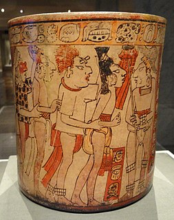
Although the Maya were once thought to have been peaceful, current theories emphasize the role of inter-polity warfare as a factor in the development and perpetuation of Maya society. The goals and motives of warfare in Maya culture are not thoroughly understood, but scholars have developed models for Maya warfare based on several lines of evidence, including fortified defenses around structure complexes, artistic and epigraphic depictions of war, and the presence of weapons such as obsidian blades and projectile points in the archaeological record. Warfare can also be identified from archaeological remains that suggest a rapid and drastic break in a fundamental pattern due to violence.

Bʼalaj Chan Kʼawiil was a Maya ruler of Dos Pilas. He is also known as Ruler 1, Flint Sky God K and Malah Chan Kʼawil.
Punta de Chimino is a Maya archaeological site in the Petexbatún region of the department of Petén in Guatemala. Occupation at the site dates to the Preclassic and Classic periods of Mesoamerican chronology. Punta de Chimino experienced a population surge in the Late Preclassic, followed by a reduction in occupation levels in the Early Classic and another increase in the Terminal Classic when the city became one of the few population centres to survive the political disintegration of the Petexbatún region after the collapse of the kingdom based at Dos Pilas. The neighbouring city of Seibal on the Pasión River appears to have intervened at Punta de Chimino at this time and to have politically dominated the smaller site.
Itzan is a Maya archaeological site located in the municipality of La Libertad in the Petén Department of Guatemala. Various small structures at the site were destroyed in the 1980s during oil exploration activities by Sonpetrol and Basic Resources Ltd, prompting rescue excavations by archaeologists. In spite of its small size, the site appears to have been the most politically important centre in its area, as evidenced by its unusually large quantity of monuments and the size of its major architecture.
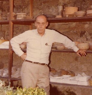
Edwin M. Shook was an American archaeologist and Mayanist scholar, best known for his extensive field work and publications on pre-Columbian Maya civilization sites.
Chanal Balam was the only known king of Maya city-state Tamarindito in Guatemala. The sculptures at Tamarindito indicate a long dynastic history with more than 25 rulers, although only a few can be named, and one of them is Chanal Balam.
The Second Tikal–Calakmul War was the second in a series of wars between Tikal and Calakmul known as The Tikal–Calakmul wars. Tikal and Calakmul were some of the most prosperous cities in Peten during the classic period of Mesoamerican chronology. After the classic came the post classic which was characterized by a decline in Maya Civilization. During that time both Tikal and Calakmul were abandoned.
The history of Maya civilization is divided into three principal periods: the Preclassic, Classic and Postclassic periods; these were preceded by the Archaic Period, which saw the first settled villages and early developments in agriculture. Modern scholars regard these periods as arbitrary divisions of chronology of the Maya civilization, rather than indicative of cultural evolution or decadence. Definitions of the start and end dates of period spans can vary by as much as a century, depending on the author. The Preclassic lasted from approximately 2000 BC to approximately 250 AD; this was followed by the Classic, from 250 AD to roughly 950 AD, then by the Postclassic, from 950 AD to the middle of the 16th century. Each period is further subdivided:

