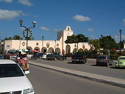
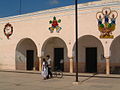
Oxkutzcab Municipality is a municipality, with a municipal seat of the same name in the Mexican state of Yucatán, southeast of Maní, Yucatán, located at 20°18′10″N89°25′0″W. The name in the Yucatec Maya language means "Place of ramon, tobacco, and honey".

Tekax, sometimes spelled Tecax, is a small city in the Mexican state of Yucatán, located at 20°12′07″N89°17′17″W in the southernmost part of the state. Tekax means "Place of the Forests" in the Yucatec Maya language. Tekax was briefly declared the capital of Yucatán in 1845. Tekax is also the name of the surrounding municipality of which the city of Tekax serves as municipal seat of government.
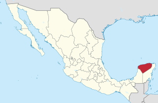
Yucatán is a state in southeastern Mexico that is divided into 106 municipalities, organized into 7 administrative regions. According to the 2020 Mexican census, it is the twenty-second most populated state with 2,320,898 inhabitants and the 20th largest by land area spanning 39,524.4 square kilometres (15,260.5 sq mi).

Mérida Municipality is one of the 106 municipalities in the Mexican state of Yucatán containing (858.41 km2) of land with the head or seat being the city of Mérida. Because the archaeological remains of the Maya reminded the Spaniards of the ancient city of Mérida, Spain, which was marked by Roman archaeological sites, they renamed the site of T-hó after the Spanish city.

Armería is a municipality in the south-central part of the Mexican state of Colima. Ciudad de Armería is a city and the seat of Armería municipality. The municipality reported 29,599 inhabitants in the 2015 census and has an area of 341.60 km². Its municipal seat is Ciudad de Armería.

Teabo Municipality is one of the 106 subdivisions of the State of Yucatán in Mexico. Its municipal seat is located in the town of Teabo.

Tekantó Municipality is a small (47.25 km²) municipality in the Mexican state of Yucatán. The municipality was formed in 1900 and its municipal seat is the homonymous locality of Tekantó, at the end of highway 80, 54 km east of Merida.
Santa Elena Municipality is one of the 106 municipalities in the Mexican state of Yucatán containing (694.90 km2) of land and is located roughly 95 km south of the city of Mérida.
Chapab Municipality is one of the 106 municipalities in the Mexican state of Yucatán containing (168.62 km2) of land and located roughly 85 km south of the city of Mérida.

Baca Municipality is one of the 106 municipalities in the Mexican state of Yucatán containing (118.78 km2) of land and located roughly 32 km east of the city of Mérida.

Yobaín Municipality is one of the 106 municipalities in the Mexican state of Yucatán containing (81.75 km2) of land and located roughly 70 km northeast of the city of Mérida.

Uayma Municipality is one of the 106 municipalities in the Mexican state of Yucatán, containing (196.72 km2) of land and located roughly 165 km east of the city of Mérida.

Cantamayec is one of the 106 municipalities in the Mexican state of Yucatán containing (502.02 km2) of land and located roughly 110 km southeast of the city of Mérida.

Dzán Municipality is one of the 106 municipalities in the Mexican state of Yucatán containing (61.31 km2) of land and is located roughly 95 km south of the city of Mérida.

Maní Municipality is one of the 106 municipalities in the Mexican state of Yucatán containing (85.59 km2) of land and is located roughly 90 km south of the city of Mérida.
Mayapán Municipality is one of the 106 municipalities in the Mexican state of Yucatán containing (103.47 km2) of land and is roughly 95 km southeast of the city of Mérida.
Muna Municipality is one of the 106 municipalities in the Mexican state of Yucatán containing (270.81 km2) of land and is located roughly 50 km south of the city of Mérida.
Sacalum Municipality is one of the 106 municipalities in the Mexican state of Yucatán containing (205.66 km2) of land and is located roughly 75 km south of the city of Mérida.
Tekit Municipality is one of the 106 municipalities in the Mexican state of Yucatán containing (219.71 km2) of land and is located roughly 65 km southeast of the city of Mérida.

Tinúm Municipality is one of the 106 municipalities in the Mexican state of Yucatán containing of land and is located roughly 140 kilometres (87 mi) east of the city of Mérida.