Dzitás Municipality

Last updated • 2 min readFrom Wikipedia, The Free Encyclopedia
Dzitás
Municipios de Yucatan con regiones.svg
Region 6 Oriente #030
Mexico States blank map.svg
Red pog.svg
Dzitás
Location of the Municipality in Mexico
Coordinates: 20°50′22″N88°31′34″W / 20.83944°N 88.52611°W / 20.83944; -88.52611
Country Flag of Mexico.svg Mexico
State Flag of Yucatan.svg Yucatán
Mexico Ind.1821
Yucatán Est.1824
Government
  Type PRI Party (Mexico).svg 2012–2015 [1]
  Municipal PresidentJosé Crescencio Canul Polanco [2]
Area
  Total456.03 km2 (176.07 sq mi)
  [2]
Elevation
[2]
32 m (105 ft)
Population
 (2010 [3] )
  Total3,540
  Density7.8/km2 (20/sq mi)
   Demonym
Umanense
Time zone UTC-6 (Central Standard Time)
  Summer (DST) UTC-5 (Central Daylight Time)
INEGI Code101
Major Airport Merida (Manuel Crescencio Rejón) International Airport
IATA Code MID
ICAO Code MMMD
Municipalities of Yucatán

Dzitás Municipality (In the Yucatec Maya Language: “plant name: mamay or plantain") is a municipality in the Mexican state of Yucatán containing (456.03 km2) of land and is located roughly 125 km east of the city of Mérida. [2]

Contents

History

There is no accurate data on when the town was founded, though it existed before the conquest as part of the province of Cupules. At colonization, Dzitás became part of the encomienda system. [2] What is now known as Dzitas was divided into two different encomiendos. Part was designated to Juan Rodrígez in 1549 and the other to Diego de Alcocer. In 1579 the first part was held by Juan Rodrígez and Diego de Alcocer and the second by Diego de Alcocer and Francisca Briceño. The parts were divided between Luis Carrillo de Albornoz and Francisco Rodríguez Montalvo in 1652 and in 1688 between Felipe Carrillo and Isabel Peraza de Ayala. [4]

Yucatán declared its independence from the Spanish Crown in 1821, and in 1825 the area was assigned to the partition of Valladolid Municipality. In 1918 it was designated as its own municipality, but lost a portion of its area in 1931 with the creation of Quintana Roo Municipality. [2]

In 1931 the anthropologists Robert and Margaret Park Redfield stayed in the county seat of Dzitas for extended periods and published The Folk Culture of Yucatan, [5] and Disease and its treatment in Dzitas, Yucatan [6]

Governance

The municipal president is elected for a three-year term. The town council has four councilpersons, who serve as Secretary and councilors of public works, public monuments and markets. [7]

Communities

The head of the municipality is Dzitás, Yucatán. There are 10 populated areas of the municipality [7] with the most important being Dzitás, Dzitcacao, Santa Rosa, Xocempich and Yaxché. The significant populations are shown below: [2]

CommunityPopulation
Entire Municipality (2010)3,540 [3]
Dzitás2826 in 2005 [8]
Xocempich563 in 2005 [9]

Local festivals

Every year from 16 to 22 January is the Festival of Santa Inés, patron saint of the town. [2]

Tourist attractions

Related Research Articles

<span class="mw-page-title-main">Tunkás Municipality</span> Municipality in the Mexican state of Yucatán

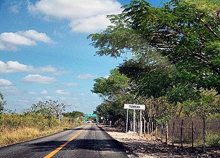
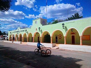
Tunkás Municipality is one of the 106 municipalities in the Mexican state of Yucatán containing 514.79 square kilometres (198.76 sq mi) of land and located roughly 98 kilometres (61 mi) east of the city of Mérida.

<span class="mw-page-title-main">Hunucmá Municipality</span> Municipality in the Mexican state of Yucatán

Hunucmá Municipality is one of the 106 municipalities in the Mexican state of Yucatán containing (599.10 km2) of land and located roughly 25 km west of the city of Mérida.

<span class="mw-page-title-main">Yaxcabá Municipality</span> Municipality in Yucatán, Mexico

Yaxcabá Municipality is one of the 106 municipalities in the Mexican state of Yucatán containing (1079 km2) of land and located roughly 80 km northeast of the city of Mérida.

<span class="mw-page-title-main">Homún Municipality</span> Municipality in the Mexican state of Yucatán

Homún Municipality is one of the 106 municipalities in the Mexican state of Yucatán containing (192.89 km2) of land and located roughly 50 km southeast of the city of Mérida.

<span class="mw-page-title-main">Izamal Municipality</span> Municipality in the Mexican state of Yucatán

Izamal Municipality is one of the 106 municipalities in the Mexican state of Yucatán containing (275.92 km2) of land and located roughly 67 km east of the city of Mérida.

<span class="mw-page-title-main">Quintana Roo Municipality</span> Municipality in the Mexican state of Yucatán

Quintana Roo Municipality is one of the 106 municipalities in the Mexican state of Yucatán containing (139.24 km2) of land and located roughly 104 km east of the city of Mérida.

<span class="mw-page-title-main">Tahmek Municipality</span> Municipality in the Mexican state of Yucatán

Tahmek Municipality is one of the 106 municipalities in the Mexican state of Yucatán containing (139.24 km2) of land and located roughly 39 km southeast of the city of Mérida.

<span class="mw-page-title-main">Sinanché Municipality</span> Municipality in the Mexican state of Yucatán

Sinanché Municipality is one of the 106 municipalities in the Mexican state of Yucatán containing 131.57 square kilometres (50.80 sq mi) of land and located roughly 60 kilometres (37 mi) northeast of the city of Mérida.

<span class="mw-page-title-main">Yobaín Municipality</span> Municipality in the Mexican state of Yucatán

Yobaín Municipality is one of the 106 municipalities in the Mexican state of Yucatán containing (81.75 km2) of land and located roughly 70 km northeast of the city of Mérida.

<span class="mw-page-title-main">Chankom Municipality</span> Municipality in the Mexican state of Yucatán

Chankom Municipality is a municipality in the Mexican state of Yucatán containing (137.95 km2) of land and located roughly 135 km southeast of the city of Mérida.

<span class="mw-page-title-main">Chichimilá Municipality</span> Municipality in the Mexican state of Yucatán

Chichimilá Municipality is a municipality in the Mexican state of Yucatán containing (358.59 km2) of land and located roughly 170 km southeast of the city of Mérida.

<span class="mw-page-title-main">Chikindzonot Municipality</span> Municipality in the Mexican state of Yucatán

Chikindzonot Municipality is a municipality in the Mexican state of Yucatán containing (352.56 km2) of land and located roughly 170 km southeast of the city of Mérida.

<span class="mw-page-title-main">Cantamayec Municipality</span> Municipality in the Mexican state of Yucatán

Cantamayec is a municipality in the Mexican state of Yucatán containing (502.02 km2) of land and located roughly 110 km southeast of the city of Mérida.

<span class="mw-page-title-main">Muna Municipality</span> Municipality in the Mexican state of Yucatán

Muna Municipality is one of the 106 municipalities in the Mexican state of Yucatán containing (270.81 km2) of land and is located roughly 50 km south of the city of Mérida.

<span class="mw-page-title-main">Buctzotz Municipality</span> Municipality in the Mexican state of Yucatán

Buctzotz Municipality is a municipality in the Mexican state of Yucatán containing (543.45 km2) of land and is located roughly 95 kilometres (59 mi) northeast of the city of Mérida. It contains several churches and a hospital, Centre de Salud Buctzotz, in the eastern part of the main town.

<span class="mw-page-title-main">Cenotillo Municipality</span> Municipality in the Mexican state of Yucatán

Cenotillo Municipality is a municipality in the Mexican state of Yucatán containing (614.43 km2) of land and is located roughly 115 kilometres (71 mi) east of the city of Mérida.

<span class="mw-page-title-main">Akil Municipality</span> Municipality in the Mexican state of Yucatán

Akil Municipality is a municipality in the Mexican state of Yucatán containing (48.54 km2) of land and is located roughly 100 kilometres (62 mi) southeast of the Capital State.

<span class="mw-page-title-main">Tekax Municipality</span> Municipality in the Mexican state of Yucatán

Tekax Municipality is one of the 106 municipalities in the Mexican state of Yucatán containing (3,819.61 km2) of land and is located roughly 125 kilometres (78 mi) southeast of the city of Mérida.

<span class="mw-page-title-main">Kaua Municipality</span> Municipality in the Mexican state of Yucatán

Kaua Municipality is one of the 106 municipalities in the Mexican state of Yucatán containing (214.60 km2) of land and is located roughly 135 kilometres (84 mi) southeast of the city of Mérida.

<span class="mw-page-title-main">Opichén Municipality</span> Municipality in the Mexican state of Yucatán

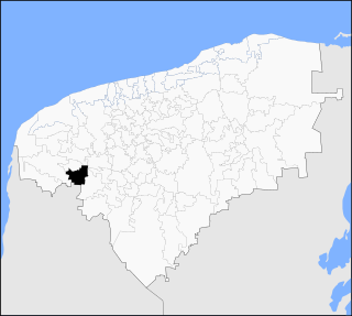
Opichén Municipality is one of the 106 municipalities in the Mexican state of Yucatán containing (268.25 km2) of land and is located roughly 75 kilometres (47 mi) south of the city of Mérida.

References

  1. "Presidentes Municipales" (in Spanish). Mérida, Mexico: PRI yucatan. 23 January 2014. Archived from the original on 3 July 2015. Retrieved 2 August 2015.
  2. 1 2 3 4 5 6 7 8 "Municipios de Yucatán »Dzitás" (in Spanish). Retrieved 2 August 2015.
  3. 1 2 "Mexico In Figures:Dzitás, Yucatán". INEGI (in Spanish and English). Aguascalientes, México: Instituto Nacional de Estadística y Geografía (INEGI). Archived from the original on 6 May 2015. Retrieved 1 August 2015.
  4. García Bernal, Manuela Cristina (1978). Población y encomienda en Yucatán bajo los Austrias (in Spanish). Sevilla: Escuela de Estudios Hispano-Americanos. pp. 508–509. ISBN   978-8-400-04399-5 . Retrieved 1 August 2015.
  5. Redfield, Robert (1941). The Folk Culture of Yucatan. U of Chicago Press.
  6. Redfield, Margaret Park and Robert Redfield (1940). Disease and its treatment in Dzitas, Yucatan. Carnegie Institution of Washington.
  7. 1 2 "Dzitás". inafed (in Spanish). Mérida, Mexico: Enciclopedia de Los Municipios y Delegaciones de México. Archived from the original on 8 May 2014. Retrieved 2 August 2015.
  8. "Dzitás". PueblosAmerica (in Spanish). PueblosAmerica. 2005. Retrieved 2 August 2015.
  9. "Xocempich". PueblosAmerica (in Spanish). PueblosAmerica. 2005. Retrieved 2 August 2015.