Umán Municipality is one of the 106 municipalities in the Mexican state of Yucatán containing (234.30 km2) of land and located roughly 15 km southwest of the city of Mérida. The word "Umán" means “purchase” in the Yucatec Maya language.

Maxcanú Municipality is one of the 106 municipalities in the Mexican state of Yucatán. Its seat is the town of Maxcanú. The municipality covers an area of approximately 1,321 km2 and is located roughly 52 km southwest of the city of Mérida.
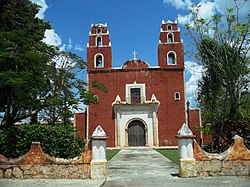
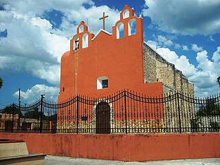
Halachó Municipality is one of the 106 municipalities in the Mexican state of Yucatán containing (671.91 km2) of land and located roughly 68 km southwest of the city of Mérida.

Kanasín Municipality is one of the 106 municipalities in the Mexican state of Yucatán containing (72.81 km2) of land and located roughly 5 km east of the city of Mérida.

Tixkokob Municipality is one of the 106 subdivisions of the State of Yucatán in Mexico. Its municipal seat is located in the City of Tixkokob. The town of Tixkokob is famous within the area for high quality hammock weaving. The municipality made up largely of working class communities.

Hunucmá Municipality is one of the 106 municipalities in the Mexican state of Yucatán containing (599.10 km2) of land and located roughly 25 km west of the city of Mérida.

Hacienda Chenché de las Torres is located in the Temax Municipality in the state of Yucatán in southeastern Mexico. It is one of the properties that arose during the nineteenth century henequen boom, and was owned by Álvaro Peón de Regil y Joaquina Peón Castellanos, the Count and Countess of Miraflores.

Progreso Municipality is one of the 106 municipalities in the Mexican state of Yucatán containing (270.10 km2) of land and located roughly 25 km north of the city of Mérida.

Cacalchén Municipality is one of the 106 municipalities in the Mexican state of Yucatán containing (76.64 km2) of land and located roughly 40 km east of the city of Mérida.

Dzoncauich Municipality is one of the 106 municipalities in the Mexican state of Yucatán containing (355.12 km2) of land and located roughly 85 km northeast of the city of Mérida.
Quintana Roo Municipality is one of the 106 municipalities in the Mexican state of Yucatán containing (139.24 km2) of land and located roughly 104 km east of the city of Mérida.

Tekal de Venegas Municipality is one of the 106 municipalities in the Mexican state of Yucatán containing (95.80 km2) of land and located roughly 80 km east of the city of Mérida.

Dzemul Municipality (In the Yucatec Maya Language: “ravaged mound” is one of the 106 municipalities in the Mexican state of Yucatán containing 123.91 square kilometres of land and located roughly 47 kilometres northeast of the city of Mérida. There is a large Mayan archaeological site called Xcambo, which is used as a place of worship as there is a chapel built above the Mayan remains.

Mocochá Municipality is one of the 106 municipalities in the Mexican state of Yucatán containing 57.48 square kilometres (22.19 sq mi) of land and located roughly 25 kilometres (16 mi) northeast of the city of Mérida.

Muxupip Municipality is one of the 106 municipalities in the Mexican state of Yucatán containing 54.93 square kilometres (21.21 sq mi) of land and located roughly 30 kilometres (19 mi) northeast of the city of Mérida. It is bounded on the north by Motul town, on the south by Cacalchén Municipality and on the east and the west by Yaxkukul Municipality and Tixkokob Municipality.

Yaxkukul Municipality is one of the 106 municipalities in the Mexican state of Yucatán, containing 43.43 kilometres (26.99 mi) of land and located roughly 25 kilometres (16 mi) northeast of the city of Mérida. Survey maps of Yaxkukul cite its full name as "Santa Cruz de Mayo Yaxkukul".

Yobaín Municipality is one of the 106 municipalities in the Mexican state of Yucatán containing (81.75 km2) of land and located roughly 70 km northeast of the city of Mérida.
Muna Municipality is one of the 106 municipalities in the Mexican state of Yucatán containing (270.81 km2) of land and is located roughly 50 km south of the city of Mérida.
Buctzotz Municipality is one of the 106 municipalities in the Mexican state of Yucatán containing (543.45 km2) of land and is located roughly 95 kilometres (59 mi) northeast of the city of Mérida. It contains several churches and a hospital, Centre de Salud Buctzotz, in the eastern part of the main town.

Hacienda Chumichén was an estate built in the mid-19th century for the aristocratic de la Cámara family. It is located in Temax, Yucatán in the southeast of Mexico.