
Gulen (help·info) is a municipality in the southwestern part of Sogn og Fjordane county, Norway. It is part of the traditional district of Sogn. The administrative center of the municipality is the village of Eivindvik. Other villages in Gulen include Brekke, Byrknes, Dalsøyra, Dingja, Instefjord, Mjømna, Rutledal, and Ytre Oppedal.

Hardbakke is the administrative centre of the municipality of Solund in Sogn og Fjordane county, Norway. The village is located on the west side of the island of Sula, just across the strait from the island of Steinsundøyna. Hardbakke is located about halfway between the islet of Holmebåen and the village of Losnegard, the western- and eastern-most points in the municipality. The 0.26-square-kilometre (64-acre) village has a population (2013) of 295, giving the village a population density of 1,135 inhabitants per square kilometre (2,940/sq mi). Hardbakke has an elementary school and a secondary school, as well as Solund Church.

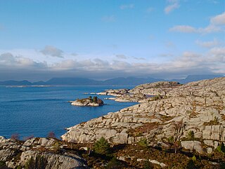
Sula is an island in the municipality of Solund in Sogn og Fjordane county, Norway. The 116-square-kilometre (45 sq mi) island is the main island of the municipality. The island is located at the mouth of the Sognefjorden on the north side of the Sognesjøen, about 18 kilometres (11 mi) east of Holmebåen, the westernmost point in Norway. The largest village on the island is Hardbakke. The other main village area is Hersvikbygda on the northern part of the island.
Kvaløya is the name of many islands in Norway:
Sognesjøen is a strait in Sogn og Fjordane county, Norway. The strait is the outermost part of the large Sognefjorden. It runs along the border between Solund and Gulen municipalities. The 35-kilometre (22 mi) long strait begins around the village of Rutledal on the mainland of Gulen at the mouth of the Sognefjorden. The strait then flows in a southwesterly direction into the North Sea, just north of the island municipality of Fedje. The Sognesjøen is surrounded by many large and small islands. The islands of Sula, Steinsundøyna, Ytre Sula lie along the northern side of the strait. The mainland and the islands of Hiserøyna, Hille, Kversøyna, and Byrknesøyna lie along the southern side of the strait.

Losna is an island in the municipality of Solund in Sogn og Fjordane county, Norway. The 15.3-square-kilometre (5.9 sq mi) island lies at the mouth of the Sognefjorden, on the north side of the Sognesjøen. The Tollesundet strait lies between the island and the mainland of Hyllestad to the east and the Krakhellasundet strait lies between the island and the nearby island of Sula to the west. The island of Sula sits only about 600 metres (2,000 ft) to the west. The highest point on the very rocky island is the 451-metre (1,480 ft) tall mountain Meinova on the northern end of the island.

Ytre Sula is an island in the municipality of Solund in Sogn og Fjordane county, Norway. The island lies along the Sognesjøen, just west of the mouth of the large Sognefjorden. The 34.7-square-kilometre (13.4 sq mi) island is part of a large island group. It is the westernmost of the three main islands in Solund. The island of Steinsundøyna lies just east of Ytre Sula. There are no road connections to the rest of Norway. To get to the mainland, one must take a ferry connection from Ytre Sula to the smaller island of Rånøyna, cross that island and cross a small bridge to Steinsundøyna, take a bridge from Steinsundøyna to Sula, and then another ferry from Sula to Rutledal in Gulen municipality on the mainland.

Steinsundøyna is an island in the municipality of Solund in Sogn og Fjordane county, Norway. The 18.7-square-kilometre (7.2 sq mi) sits on the north side of the Sognesjøen, at the mouth of the large Sognefjorden. The rocky island is virtually treeless. In 2001, there were only about 55 residents on the island. There is a road that crosses the island, connecting the islands of Ytre Sula and Sula. The largest population centre on Steinsundøyna is the village of Steinsund on the eastern coast of the island, just across the strait from the village of Hardbakke on the island of Sula.

Kolgrov is a village in Solund Municipality in Sogn og Fjordane county, Norway. The village is located on the western coast of the island of Ytre Sula, and it is one of the largest population centres on the island. The village sits about 12 kilometres (7.5 mi) directly southwest of the municipal centre of Hardbakke and about 15 kilometres (9.3 mi) northwest of the village of Byrknes in Gulen.
Solund Church is the main parish church in Solund Municipality in Sogn og Fjordane county, Norway. It is located in the village of Hardbakke on the western coast of the island of Sula. The church is part of the Solund parish in the Nordhordland deanery in the Diocese of Bjørgvin. The white, wooden church, which has about 200 seats, was consecrated on 22 November 1860 by the Bishop Jens Matthias Pram Kaurin. The architect Christian Henrik Grosch made the designs for the building.
Husøy Church is a parish church in Solund Municipality in Sogn og Fjordane county, Norway. It is located in the village of Kolgrov, on the western coast of the island of Ytre Sula. The church is part of the Solund parish in the Nordhordland deanery in the Diocese of Bjørgvin. The white, wooden church was built in 1896 by the architect Peter Andersen. The church seats about 174 people.
Hersvik Church is a parish church in Solund Municipality in Sogn og Fjordane county, Norway. It is located in the village of Hersvikbygda, on the northern part of the island of Sula. The church is part of the Solund parish in the Nordhordland deanery in the Diocese of Bjørgvin. The white, wooden church, which has 168 seats, was consecrated on 10 November 1891 by Bishop Fredrik Waldemar Hvoslef. The building was constructed using the drawings that the architect Jacob Wilhelm Nordan made for Fedje Church which is located to the south of Solund.
Hersvikbygda is a village in Solund Municipality in Sogn og Fjordane county, Norway. The village is located on the northern shores of the island of Sula, about 20 kilometres (12 mi) north of the municipal centre of Hardbakke. The village is the site of Hersvik Church, which serves the northern part of the municipality.


