
The Gulf Coast of the United States, also known as the Gulf South or the South Coast, is the coastline along the Southern United States where they meet the Gulf of Mexico. The coastal states that have a shoreline on the Gulf of Mexico are Texas, Louisiana, Mississippi, Alabama, and Florida, and these are known as the Gulf States.

New Orleans is a consolidated city-parish located along the Mississippi River in the southeastern region of the U.S. state of Louisiana. With a population of 383,997 according to the 2020 U.S. census, it is the most populous city in Louisiana and the French Louisiana region; third most populous city in the Deep South; and the twelfth-most populous city in the southeastern United States. Serving as a major port, New Orleans is considered an economic and commercial hub for the broader Gulf Coast region of the United States.

The French Quarter, also known as the Vieux Carré, is the oldest neighborhood in the city of New Orleans. After New Orleans was founded in 1718 by Jean-Baptiste Le Moyne de Bienville, the city developed around the Vieux Carré, a central square. The district is more commonly called the French Quarter today, or simply "The Quarter", related to changes in the city with American immigration after the 1803 Louisiana Purchase. Most of the extant historic buildings were constructed either in the late 18th century, during the city's period of Spanish rule, or were built during the first half of the 19th century, after U.S. purchase and statehood.

Dauphin Island is an island town in Mobile County, Alabama, United States, on a barrier island of the same name, in the Gulf of Mexico. It incorporated in 1988. The population was 1,778 at the 2020 census, up from 1,238 at the 2010 census. The town is part of the Mobile metropolitan area. The island was renamed for Louis XIV of France's great-grandson and heir, the dauphin, the future Louis XV of France. The name of the island is often mistaken as Dolphin Island; the word dauphin is French for dolphin, but historically, the term was used as the title of the heir apparent to the French monarch.

Pensacola is the westernmost city in the Florida Panhandle. It is the county seat and only city of Escambia County and one of two municipalities that are incorporated, the other being Century. At the 2020 census, the population was 54,312, up from 51,923 at the 2010 census. It is the principal city of the Pensacola Metropolitan Statistical Area, which had 509,905 residents in 2020.

Grand Isle is a town in Jefferson Parish in the U.S. state of Louisiana, located on a barrier island of the same name in the Gulf of Mexico. The island is at the mouth of Barataria Bay where it meets the gulf. The town of Grand Isle is statistically part of the New Orleans−Metairie−Kenner metropolitan statistical area, though it is not connected to New Orleans' continuous urbanized area.

Biloxi is a city in Harrison County, Mississippi, United States. It lies on the Gulf Coast in southern Mississippi, bordering the city of Gulfport to its west. The adjacent cities are both designated as seats of Harrison County. The population of Biloxi was 49,449 at the 2020 census, making it the state's 4th most populous city. It is a principal city of the Gulfport–Biloxi metropolitan area, home to 416,259 residents in 2020. The area's first European settlers were French colonists.

Gulfport is the second-most populous city in the U.S. state of Mississippi after the state capital, Jackson. Along with Biloxi, Gulfport is the co-county seat of Harrison County and part of the Gulfport–Biloxi metropolitan area. As of the 2020 census, Gulfport has a population of 72,926; the metro area has a population of 416,259. Gulfport lies along the gulf coast of the United States in southern Mississippi, taking its name from its port on the Gulf Coast on the Mississippi Sound. It is home to the U.S. Navy Atlantic Fleet Seabees.
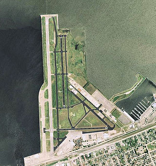
Lakefront Airport is a public airport five miles northeast of downtown New Orleans, in Orleans Parish, Louisiana, United States. The National Plan of Integrated Airport Systems for 2011–2015 categorized it as a general aviation reliever airport.

Fort Jackson is a historic masonry fort located 40 miles (64 km) up river from the mouth of the Mississippi River in Plaquemines Parish, Louisiana. It was constructed as a coastal defense of New Orleans, between 1822 and 1832, and it was a battle site during the American Civil War. It is a National Historic Landmark. It was damaged by Hurricanes Katrina and Rita, and its condition is threatened. It is marked Battery Millar on some maps, for the Endicott era work built nearby it.

Hurricane Katrina was a devastating and deadly Category 5 Atlantic hurricane that caused 1,392 fatalities and damages estimated at $186.3 billion in late August 2005, particularly in the city of New Orleans and its surrounding area. Katrina was the twelfth tropical cyclone, the fifth hurricane, and the third major hurricane of the 2005 Atlantic hurricane season. It was also the fourth-most intense Atlantic hurricane to make landfall in the contiguous United States, gauged by barometric pressure.

Hurricane Rita was the most intense tropical cyclone on record in the Gulf of Mexico and the fourth-most intense Atlantic hurricane ever recorded. Part of the record-breaking 2005 Atlantic hurricane season, which included three of the top ten most intense Atlantic hurricanes in terms of barometric pressure ever recorded, Rita was the seventeenth named storm, tenth hurricane, and fifth major hurricane of the 2005 season. It was also the earliest-forming 17th named storm in the Atlantic until Tropical Storm Rene in 2020. Rita formed near The Bahamas from a tropical wave on September 18, 2005 that originally developed off the coast of West Africa. It moved westward, and after passing through the Florida Straits, Rita entered an environment of abnormally warm waters. Moving west-northwest, it rapidly intensified to reach peak winds of 180 mph (285 km/h), achieving Category 5 status on September 21. However, it weakened to a Category 3 hurricane before making landfall in Johnson's Bayou, Louisiana, between Sabine Pass, Texas and Holly Beach, Louisiana, with winds of 115 mph (185 km/h). Rapidly weakening over land, Rita degenerated into a large low-pressure area over the lower Mississippi Valley by September 26th.

The New Orleans Public Library (NOPL) is the public library of the city of New Orleans, Louisiana, United States. Succeeding earlier libraries in the city, it opened in 1897. Three branches were added by 1908. Carnegie library branches were added in 1911 and 1915. By 2005 a dozen branches were open. The main library is listed on the National Register of Historic Places.

Fort Pike State Historic Site is a decommissioned 19th-century United States fort, named after Brigadier General Zebulon Pike. It was built following the War of 1812 to guard the Rigolets pass in Louisiana, a strait from the Gulf of Mexico, via Lake Borgne, to Lake Pontchartrain bordering New Orleans. It was located near the community of Petite Coquille, now within the city limits of New Orleans.
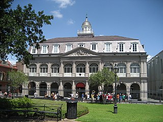
The Cabildo, originally called "Casa Capitular", is a historical building in New Orleans, Louisiana. Originally the seat of Spanish colonial city hall, the building now forms part of the Louisiana State Museum. It is located along Jackson Square, adjacent to St. Louis Cathedral.
Pelican Publishing Company is a book publisher based in Elmwood, Louisiana, with a New Orleans postal address. It was acquired in 2019 by Arcadia Publishing, a leading publisher of local and regional content in the United States.

St. Bernard State Park is a state park located in the American state of Louisiana, on a tract of land in St. Bernard Parish, between the towns of Poydras and Caernarvon. Though located only approximately eighteen miles southeast of New Orleans, attendance had been fledgling at the park for years, ranking among the least visited in the state.

The climate of Miami is classified as having a tropical monsoon climate with hot and humid summers; short, warm winters; and a marked drier season in the winter. Its sea-level elevation, coastal location, position just above the Tropic of Cancer, and proximity to the Gulf Stream shape its climate.

The following outline is provided as an overview of and topical guide to the U.S. state of Louisiana:

Grand Isle State Park, lies at the eastern tip of Grand Isle, a barrier island in Jefferson Parish, Louisiana, U.S.A. Grand Isle is the only inhabited barrier island in the state.
