Lount Township, Ontario

Last updated

Lount
Geographic township
Ontps-lount.PNG
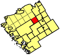
Location of Lount Township in Parry Sound District
Canada Ontario location map 2.svg
Red pog.svg
Lount
Location of Lount Township in Ontario
Coordinates: 45°49′59″N79°38′56″W / 45.83306°N 79.64889°W / 45.83306; -79.64889
CountryCanada
Province Ontario
Municipality Parry Sound, Unorganized, Centre
Time zone UTC-5 (Eastern Time Zone)
  Summer (DST) UTC-4 (Eastern Time Zone)
Postal code FSA
P0A
Area codes 705, 249

Lount is a geographic township in the Unorganized Centre Part of Parry Sound District in Central Ontario, Canada. [1] [2] [3] The communities of Bummer's Roost, Rye and Wattenwyle are located in the township. It originally was settled by the building of the Rosseau and Nipssing Road which cuts diagonally through the township. [2] Lount is part of the Almaguin Highlands region.

Contents

Etymology

This township in Parry Sound District was named in 1874 for William Lount (1840-1903), Liberal member for Simcoe North in the Legislative Assembly of Ontario, 1867–71, and for Toronto Centre in the House of Commons, 1896–7. He was subsequently appointed a judge in the High Court of Ontario. William Lount was a nephew of Samuel Lount, who led a party of reformers in the Rebellion of 1837 and was put to death the following year. [4]

See also

Related Research Articles

<span class="mw-page-title-main">Parry Sound District</span> District in Ontario, Canada

Parry Sound District is a census division of the Canadian province of Ontario. Its boundaries are District of Muskoka to the south, the Sudbury District to the north-northwest, the French River and Lake Nipissing in the north, Nipissing District and North Bay in the north and east and parts of Algonquin Park in the northeast.

<span class="mw-page-title-main">The Archipelago</span> Township in Ontario, Canada

The Archipelago is a township in central Ontario, Canada, along the Georgian Bay in the Parry Sound District.

<span class="mw-page-title-main">Unorganized Centre Parry Sound District</span> Unorganized area in Ontario, Canada

Unorganized Centre Parry Sound District is an unorganized area in central Ontario, Canada, between Georgian Bay and Lake Nipissing in the District of Parry Sound. It is made up of geographic townships which have no governing bodies and which are not incorporated as municipalities. The territory consists of two non-contiguous areas, with the main part located directly south of the French River and Lake Nipissing, and east of Georgian Bay. Shawanaga Township is a small exclave south of it along Highway 69.

<span class="mw-page-title-main">Restoule</span> Designated place with Local Services Board in Ontario, Canada

Restoule is a community and designated place in geographic Patterson Township in the Centre Unorganized Part of Parry Sound District in Central Ontario, Canada. It is situated on the Restoule River between Commanda Lake, and Restoule Lake and is part of the Almaguin Highlands region.

<span class="mw-page-title-main">Seguin River</span> River in Ontario, Canada

The Seguin River is a river in Parry Sound District in central Ontario, Canada that empties into Parry Sound on Georgian Bay, Lake Huron at the town of Parry Sound. The river's name comes from the Ojibwe word ziigwan, meaning "spring".

King's Highway 400, commonly referred to as Highway 400, historically as the Toronto–Barrie Highway, and colloquially as the 400, is a 400-series highway in the Canadian province of Ontario linking the city of Toronto in the urban and agricultural south of the province with the scenic and sparsely populated central and northern regions. The portion of the highway between Toronto and Lake Simcoe roughly traces the route of the Toronto Carrying-Place Trail, a historic trail between the Lower and Upper Great Lakes. North of Highway 12, in combination with Highway 69, it forms a branch of the Trans-Canada Highway (TCH), the Georgian Bay Route, and is part of the highest-capacity route from southern Ontario to the Canadian West, via a connection with the mainline of the TCH in Sudbury. The highway also serves as the primary route from Toronto to southern Georgian Bay and Muskoka, areas collectively known as cottage country. The highway is patrolled by the Ontario Provincial Police and has a speed limit of 100 km/h (62 mph), except for the section south of the 401, where the speed limit is 80 km/h (50 mph).

<span class="mw-page-title-main">Parry Sound</span> Sound in Canada

Parry Sound is a sound or bay of Georgian Bay on Lake Huron, in Ontario, Canada. It is highly irregularly shaped with many deep bays and islands. Killbear Provincial Park is located on the large peninsula that separates the sound from Georgian Bay, while it is bordered on the south side by Parry Island, home of the Wasauksing First Nation, Wasauksing being the First Nation's name for the bay. At the head of the sound is the namesake town that is the largest community on the shores of Georgian Bay from Severn Sound to Manitoulin Island.

<span class="mw-page-title-main">Nipissing, Ontario</span> Township in Ontario, Canada

Nipissing is an incorporated (political) township in Parry Sound District in Central Ontario, Canada. It is on Lake Nipissing and is part of the Almaguin Highlands region. Nipissing was surveyed between 1874 and 1881, and was incorporated in 1888. Among the first settlers in the area were the Chapman and Beatty families. Nipissing Township annexed Gurd Township in 1970. The township also contains a community named Nipissing, which is located on the South River near Chapman's Landing, on the South Bay of Lake Nipissing. The township administrative offices are located in Nipissing.

<span class="mw-page-title-main">Samuel Lount</span> Canadian politician (1791–1838)

Samuel Lount was a blacksmith, farmer, magistrate and member of the Legislative Assembly in the province of Upper Canada for Simcoe County from 1834 to 1836. He was an organizer of the failed Upper Canada Rebellion of 1837, for which he was hanged as a traitor. His execution made him a martyr to the Upper Canadian Reform movement.

<span class="mw-page-title-main">Armour, Ontario</span> Township municipality in Ontario, Canada

Armour is a township municipality in the Canadian province of Ontario.

<span class="mw-page-title-main">South Algonquin</span> Township municipality in Ontario, Canada

South Algonquin is a township municipality in Nipissing District, Ontario, Canada. Located south of Algonquin Provincial Park, it is the sole populated portion of the district that lies south of the traditional dividing line between Northern Ontario and Southern Ontario and is closer connected to Renfrew County as opposed to the core portions of Nipissing District.

<span class="mw-page-title-main">Trout Creek, Ontario</span> Place in Ontario, Canada

Trout Creek is a community and unincorporated area in the municipality of Powassan, Parry Sound District in Northern Ontario, Canada. It is in geographic South Himsworth Township; is located on Ontario Highway 11, 12 kilometres (7 mi) south of the town centre of Powassan; and is part of the Almaguin Highlands.

<span class="mw-page-title-main">Dunchurch, Ontario</span> Compact rural community in Parry Sound District, Ontario, Canada

Dunchurch is a compact rural community in the Canadian province of Ontario, located in the municipality of Whitestone in Parry Sound District.

Unorganized North East Parry Sound District is an unorganized area in Parry Sound District in Central Ontario, Canada. It is served by the local services board of Laurier and is part of the Almaguin Highlands region. The region had a population of 179 in the Canada 2021 Census, and a land area of 183.04 square kilometres.

<span class="mw-page-title-main">Almaguin Highlands</span> Inter-region in Ontario, Canada

The Almaguin Highlands Region in Ontario, Canada, covers approximately 5,200 km2 (2,000 sq mi) comprising the eastern half of Parry Sound District. It is bounded by Muskoka in the south, and by Lake Nipissing and Nipissing District in the north. The eastern edge abuts the western boundary of Algonquin Provincial Park, whereas the western boundary of the Almaguin Highlands is generally regarded to be the mid east-west point of Parry Sound District. Originally derived from the words Algonquin, Magnetawan, and Seguin. the name Almaguin is now used to describe the marketing region of East Parry Sound.

Shawanaga is an unincorporated geographic township in the Unorganized Centre Part of Parry Sound District in central Ontario, Canada.

Ravensworth is an unincorporated place and former railway point in the municipality of Kearney, Parry Sound District in Central Ontario, Canada. It is located at the present day intersection of Rain Lake Road and the north end of Aholas Drive, about 8 kilometres (5 mi) east of the centre of Kearney. The community was once a station on the Ottawa, Arnprior and Parry Sound Railway, but it was decommissioned in 1959. The railbed was converted into Rain Lake Road to allow continued access to Ravensworth and other communities along the route.

Mowat is an unorganized geographic township in the Canadian province of Ontario, located within the Parry Sound District. Part of the census subdivision of Unorganized Centre Parry Sound District, the township includes the communities of Bon Air, Cranberry and Key River, the ghost towns of Ludgate and Pakesley and the rail sidings of Mowat and Wanikewin.

Pringle is an unorganized geographic township in Parry Sound District, Ontario, Canada. It is topographically part of the Almaguin Highlands region, and is part of the census subdivision of Unorganized Centre Parry Sound District. The township includes the communities of Bear Valley, Carr, Farleys Corners and Golden Valley. Although not an incorporated municipality, the township is served by two local services boards: Bear Valley and Golden Valley are served by the LSB of Loring, Port Loring and District, while Carr and Farleys Corners are served by the LSB of Restoule.

Wallbridge is an unorganized geographic township in Parry Sound District, Ontario, Canada. Part of the census subdivision of Unorganized Centre Parry Sound District, the township includes the communities of Britt, Byng Inlet and Harris Lake and the rail sidings of Drocourt and North Magnetawan. Although not an incorporated municipality, Britt and Byng Inlet are jointly served by a local services board.

References

  1. "Lount". Geographical Names Data Base . Natural Resources Canada . Retrieved 2011-11-11.
  2. 1 2 "Lount" (PDF). Geology Ontario - Historic Claim Maps. Ontario Ministry of Northern Development, Mines and Forestry. Archived from the original (PDF) on 2012-04-26. Retrieved 2011-11-11.
  3. "Ontario Map #4". Restructured municipalities. Ontario Ministry of Municipal Affairs and Housing. 2008. Retrieved 2011-11-11.
  4. Rayburn, Alan (1997). Place Names of Ontario. Toronto: University of Toronto Press. p. 199. ISBN   0-8020-7207-0.