The Frederick G. Gardiner Expressway, commonly known as the Gardiner Expressway or simply the Gardiner, is a partially at grade and elevated municipal expressway in Toronto, Ontario, Canada. Running close to the shore of Lake Ontario, it extends from the foot of the Don Valley Parkway (DVP) in the east, just past the mouth of the Don River, to the junction of Highway 427 and the Queen Elizabeth Way (QEW) in the west, for a total length of 18.0 kilometres (11.2 mi). East of Dufferin Street to just east of the Don River, the roadway is elevated for a length of 6.8 kilometres (4.2 mi), unofficially making it the longest bridge in Ontario.

Harbourfront is a neighbourhood on the northern shore of Lake Ontario within downtown Toronto, Ontario, Canada. Part of the Toronto waterfront, Harbourfront extends from Bathurst Street in the west, along Queens Quay, with its ill-defined eastern boundary being either Yonge Street or York Street. Its northern boundary is the Gardiner Expressway. Much of the district was former water lots filled in during the early 1900s to create a larger harbour district. After shipping patterns changed and the use of the Toronto Harbour declined, the area was converted from industrial uses to a mixed-use district that is mostly residential and leisure.

The Toronto waterfront is the lakeshore of Lake Ontario in the city of Toronto, Ontario, Canada. It spans 46 kilometres between the mouth of Etobicoke Creek in the west and the Rouge River in the east.

Toronto Harbour or Toronto Bay is a natural bay on the north shore of Lake Ontario, in Toronto, Ontario, Canada. Today, the harbour is used primarily for recreational boating, including personal vessels and pleasure boats providing scenic or party cruises. Ferries travel from docks on the mainland to the Islands, and cargo ships deliver aggregates and raw sugar to industries located in the harbour. Historically, the harbour has been used for military vessels, passenger traffic and cargo traffic. Waterfront uses include residential, recreational, cultural, commercial and industrial sites.

Union is a subway station on Line 1 Yonge–University of the Toronto subway in Toronto, Ontario, Canada. It opened in 1954 as one of twelve original stations on the first phase of the Yonge line, the first rapid transit line in Canada. It was the southern terminus of the line until the opening of the University line in 1963, and is today the inflection point of the U-shaped line. Along with Spadina station and Queens Quay station, it is one of three stations open overnight to support late-night streetcar routes.

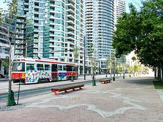
509 Harbourfront is a Toronto streetcar route in Ontario, Canada, operated by the Toronto Transit Commission and connecting Union Station with Exhibition Loop.

Queens Quay is a prominent street in the Harbourfront neighbourhood of Toronto, Ontario, Canada. The street was originally commercial in nature due to the many working piers along the waterfront; parts of it have been extensively rebuilt in since the 1970s with parks, condominiums, retail, as well as institutional and cultural development.

Queen's Quay Terminal is a condominium apartment, office and retail complex in the Harbourfront neighbourhood in Toronto, Ontario, Canada. It was originally built in 1927 as a marine terminal with office, warehouse and cold-storage facilities. When shipping to Toronto declined in the 1960s and 1970s, the building was bought by the Government of Canada to be repurposed along with a section of the industrial waterfront. The Terminal Building itself was rebuilt in the 1980s with the addition of four floors of residential above the original facility, which was converted into retail and office uses. The cold storage wing was demolished and its plant building became The Power Plant gallery and Harbourfront Centre Theatre.

Downtown Toronto is the main city centre of Toronto, Ontario, Canada. Located entirely within the district of Old Toronto, it is approximately 16.6 square kilometres in area, bounded by Bloor Street to the north, Lake Ontario to the south, the Don Valley to the east, and Bathurst Street to the west. It is also the home of the municipal government of Toronto and the Government of Ontario.

HTO Park is an urban beach in Toronto, Ontario, Canada, that opened in 2007. It is located west of Harbourfront Centre, on Lake Ontario.

Waterfront Toronto is an organization that oversees revitalization projects along the Toronto waterfront. Established in 2001 as a public–public partnership between the City of Toronto, Province of Ontario and Government of Canada, the organization is administering several blocks of land redevelopment projects surrounding Toronto Harbour and various other initiatives to promote the revitalization of the area, including public transit, housing developments, brownfield rehabilitation, possible removal of the Gardiner Expressway in the area, the Martin Goodman Trail and lakeshore improvements, and naturalization of the Don River. Actual development of the projects is done by other entities, primarily private corporations. The projects include a series of wavedeck walkways and gathering places designed by West 8 and DTAH.

Claude Cormier was a Canadian landscape architect from Quebec. The majority of his projects are located in Montreal and Toronto. His landscape practice was founded in 1994. In March 2022, the practice Claude Cormier + associes became CCxA in light of new partners.

Turning loops of the Toronto streetcar system serve as termini and turnback points for streetcar routes in Toronto, Ontario, Canada. The single-ended streetcars require track loops in order to reverse direction. Besides short off-street track loops these can also be larger interchange points, having shelters and driver facilities, or be part of a subway station structure for convenient passenger interchange.

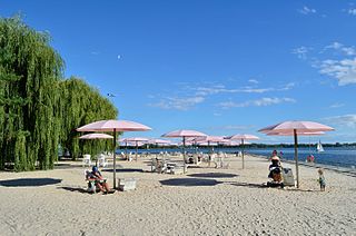
Sugar Beach is an urban beach park in Toronto, Ontario, Canada, that opened in 2010. It is located across from Redpath Sugar Refinery in Toronto's eastern East Bayfront. Like HTO Park to the west, the beach is not meant for wading or swimming in Lake Ontario, but rather functions as a waterfront public space for relaxation, leisure, and social activities. It cost $14 million.
East Bayfront LRT, also known as the Waterfront East LRT, is a planned Toronto streetcar line that would serve the East Bayfront and Port Lands areas in Toronto, Ontario, Canada. It would run from Union station under Bay Street and along Queens Quay and Cherry Street to a new loop along Commissioners Street east of Cherry Street on Ookwemin Minising. It would complement the existing 509 Harbourfront service that connects Union Station to Queens Quay west of Bay Street. Longer-term plans are to extend the East Bayfront line from Cherry and Commissioners Streets to the planned East Harbour Transit Hub along GO Transit's Lakeshore East line and the planned Ontario Line.

Sherbourne Common, designed by landscape architect Phillips Farevaag Smallenberg, is a waterfront park located in a former industrial area of Toronto. It is one of the earliest parks in Canada to incorporate a neighborhood-wide stormwater treatment facility into its design. Located east of Lower Sherbourne Street, the 1.47 hectare park spans two city blocks. It stretches from Lake Ontario to Lake Shore Boulevard in the north.

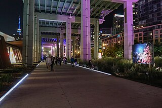
The Bentway, formerly Project: Under Gardiner, is a public trail and corridor space underneath the Gardiner Expressway in Toronto, Ontario, Canada. It is repurposed land that was in sections vacant, rail lines, parking lots and outdoor storage.

Quayside is a waterfront district Toronto, Ontario, Canada, located between Queens Quay East and Parliament Street. The 4.9 hectares site is owned by Waterfront Toronto, the City of Toronto and CreateTO and private landowners. In June 2023, Waterfront Toronto proposed a new master-planned mixed-use development of the former dockland and industrial site to succeed Sidewalk Toronto, an unrealised smart city proposed by Alphabet Inc. subsidiary Sidewalk Labs.
Pat Hanson is a Canadian architect based in Toronto and a founding principal of gh3, an architecture practice which she co-leads with Raymond Chow. The office focuses on projects that blend architecture, landscape, and urbanism. Currently gh3 -- under Hanson's leadership -- has won six Governor General's Medal in Architecture awards. This award is considered "the highest recognition for building architecture in Canada." Hanson has been inducted into the RAIC College of Fellows and has become a WLI Champion by the Urban Land Institute, which celebrate's women's leadership in building a stronger Toronto Region through responsible use of land. Hanson is also a founding member of the Women’s Architectural League.


