
The Enchantments is a region within the Alpine Lakes Wilderness area of Washington state's Cascade Mountain Range. At an elevation of 4,500 feet, it is home to over 700 alpine lakes and ponds surrounded by the vast peaks of Cashmere Crags, which rate among the best rock-climbing sites in the western United States. The highest peak, Dragontail Peak, stretches 8,840 feet high. The Enchantments is located 15 miles southwest of the popular Bavarian-themed town Leavenworth, Washington in the United States and is regarded as one of the most spectacular regions in the Cascade Range.

Icicle Creek is a non navigable stream in the U.S. state of Washington. It originates at Josephine Lake near the crest of the Cascade Range and flows generally east to join the Wenatchee River near Leavenworth. Icicle Creek's drainage basin is mountainous and mostly undeveloped land within the Wenatchee National Forest and the Alpine Lakes Wilderness. The final 6 miles (10 km) of the creek are moderately developed with scattered homes and pasture, a golf course, children's camp, a small housing development called Icicle Island Club, and the Leavenworth National Fish Hatchery. Some water is diverted from the creek for municipal use by the City of Leavenworth at Icicle Creek river mile 5.6. Near Leavenworth, the wheelchair-accessible Icicle Creek Nature Trail, a National Recreation Trail designated in 2005, runs 1.0 mile (1.6 km) along a historic creek channel.

Grindstone Mountain is a 7,533-foot (2,296-metre) mountain summit located in the Icicle Creek Valley in Chelan County of Washington state. Grindstone Mountain is situated 12 mi (19 km) west of Leavenworth, within the Alpine Lakes Wilderness, on land managed by the Okanogan–Wenatchee National Forest. Grindstone Mountain is the seventh-highest peak in the Chiwaukum Mountains, a subset of the Cascade Range. Its nearest higher neighbor is Ladies Peak, 2.2 mi (3.5 km) to the north-northwest, and Cape Horn is set 1.4 mi (2.3 km) to the north. Precipitation runoff from Grindstone drains into Icicle Creek, which is a tributary of the Wenatchee River. Although modest in elevation, relief is significant since Grindstone rises 4,700 feet above Icicle Creek Valley in less than two miles. Grindstone Mountain was named by Albert Hale Sylvester in association with Grindstone Creek, which flows from Sylvester Lake on this mountain's southwest slope. Sylvester found a small grindstone which had fallen from a pack horse fording the creek.

Cape Horn is a 7,316-foot (2,230-metre) mountain summit located in Chelan County of Washington state. Cape Horn is situated 12 mi (19 km) west-northwest of Leavenworth, within the Alpine Lakes Wilderness, on land managed by the Okanogan–Wenatchee National Forest. Cape Horn is part of the Chiwaukum Mountains, a subset of the Cascade Range. The nearest higher neighbor is Ladies Peak, 0.9 mi (1.4 km) to the northwest, and Grindstone Mountain is set 1.4 mi (2.3 km) to the south. Precipitation runoff from Cape Horn drains west to Icicle Creek, whereas the east slopes drain into Chiwaukum Creek, and both are tributaries of the Wenatchee River. Although modest in elevation, relief is significant since this peak rises over 4,300 feet above Icicle Creek Valley in approximately two miles. This mountain was named by Albert Hale Sylvester in 1909 for its sharp profile.
Eightmile Lake is a reservoir lake located on the eastern slope of Eightmile Mountain, in Chelan County in Washington. It is a reservoir lake formed along the beginning route of Eightmile Creek as it exits Jack Ridge.

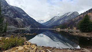
Colchuck Lake is a freshwater reservoir lake located on the western slope of the Enchantments, in Chelan County, Washington. The lake is located approximately 15 miles from the city of Leavenworth, Washington and sits on the southeast corner of the Icicle Creek subbasin. It is accessed by a 4-mile trail that starts at USFS Road 7601 as it crosses over Eightmile Creek and makes a turn towards the Stuart and Culchuck Lake Trailhead where the road ends. The origin of the word comes from Chinook Jargon kol + cak to mean cold waters.
Klonaqua Lakes are a set of freshwater reservoir lakes located on the western slope of The Enchantments, in Chelan County, Washington. A self-issued Alpine Lake Wilderness permit is required for transit within the Klonaqua Lakes area.

Snow Lakes are a system of freshwater reservoir lakes made by Upper Snow Lake and Lower Snow Lake, approximately a mile long. They are located on the eastern slope of The Enchantments, in Chelan County, Washington. The Snow Lakes are one of the most heavily used destination in the Forest Service wildernesses in Oregon and Washington. Self-issued Alpine Lakes Wilderness permits are required for transit within the Snow Lakes area.
Lake Julius is a freshwater lakes located on the north slope of the Chiwaukum Mountains, in Chelan County, Washington. Self-issued Alpine Lake Wilderness permit required for transit within the Klonaqua Lakes area. The lake is a popular area for hiking, swimming, and fishing Cutthroat trout.
Lake Alice is a freshwater lakes located on the north slope of the Grindstone Mountain, in Chelan County, Washington. The lake is a popular area for hiking, swimming, and fishing. Self-issued Alpine Lake Wilderness permit required for transit within the Lake Alice area.
Lake Sylvester is a freshwater lake located on the north slope of the Grindstone Mountain, in Chelan County, Washington. The lake is a popular area for hiking, swimming, and fishing. Lake Sylvester is located approximately 15 miles west of the city of Leavenworth and access is obtained by Chatter Creek Trail #1580. Self-issued Alpine Lake Wilderness permit required for transit within the Grindstone Mountain area.

Upper Florence Lake is a freshwater lake located on the west skirt of Ladies Peak and Cape Horn, and North of Grindstone Mountain, in Chelan County, Washington. The lake is a popular area for hiking, swimming, and fishing, especially for rainbow trout. Lower Florence Lake is located further down the slope of Mary Pass from Upper Florence Lake, approximately 15 miles west of the city of Leavenworth. Self-issued Alpine Lake Wilderness permit required for transit within the Lake Alice area.
Lake Augusta is a freshwater lake located on the southwest skirt of Big Jim Mountain, East of Icicle Ridge, in Chelan County, Washington. Because of its close proximity to Icicle Ridge Trail, the lake is a popular area for hiking, swimming, and fishing cutthroat trout. Smaller Lake Ida is a short distance on the opposite side of Icicle Ridge and Big Jim Mountain Lakes or on the northeast slope of the mountain. Lake Augusta is located approximately 15 miles west of the city of Leavenworth. Self-issued Alpine Lake Wilderness permit required for transit within the Lake Augusta area.
Lake Ida is a freshwater lake located along Icicle Ridge, approximately 10 miles west of the city of Leavenworth in Chelan County, Washington. Because of its close proximity to Icicle Ridge Trail, the lake is a popular area for hiking, swimming, and fishing cutthroat trout. Lake Augusta is a short distance on the opposite side of Icicle Ridge. Lake Ida sits on a highly glaciated alpine cirque, surrounded by a coniferous forest primarily larch pines and outflows into Ida Creek, a tributary of Icicle Creek. At least one unrated waterfall is found downstream as Ida Creek runs the south slope of Icicle Ridge. Self-issued Alpine Lake Wilderness permit required for transit within the Lake Ida and Augusta area.

Lake Edna is a freshwater lake located along Icicle Ridge, approximately 10 miles west of the city of Leavenworth in Chelan County, Washington. Because of its close proximity to Icicle Ridge Trail, the lake is a popular area for hiking, swimming, and fishing. Lake Alice is a short distance in a prominent cirque on the opposite side of Icicle Ridge.
Joe Lake is a freshwater lake located on the eastern skirt of Alaska Mountain at the border between King County and Kittitas County, Washington. The lake is a popular area for hiking, swimming, and fishing rainbow trout and cutthroat trout. Frequently hicked Huckleberry Mountain is just north of the lake on the opposite side of the Pacific Crest Trail. Other Alpine lakes are in the vicinity, including the Rampart Lakes a short distance south, at the base of Mount Margaret. To the east is Hibox Mountain.

Spectacle Lake is an alpine freshwater lake located on the northern skirt of Chikamin Peak and Lemah Mountain in Kittitas County on its western border with King County, Washington. Because of its proximity to surrounding peaks and mountains at the heart of the Alpine Lakes Wilderness, the lake is a popular area for hiking, camping and fishing cutthroat trout. Other Alpine lakes are in the vicinity, including the Chikamin Lake, a short distance North, at the base of Chikamin Peak. To the South is Hibox Mountain.

Icicle Ridge is a mountain ridge located in the eastern border of the Alpine Lakes Wilderness, in the Washington state, United States. Several trails lead to Icicle Ridge which borders several prominent mountains, peaks, and lakes. Icicle Ridge is located at the western edge of the city of Leavenworth on land managed by the Okanogan–Wenatchee National Forest.
Josephine Lake is a natural lake and reservoir near Stevens Pass in Chelan County, Washington, United States. At the south skirt of Big Chief Mountain, Josephine Lake is the source of the Icicle Creek. Because Josephine Lake is at the heart of the Alpine Lakes Wilderness, the lake is a popular area for hiking, swimming, and fishing golden trout.
Lake Lillian is a freshwater lake located within the Alpine Lakes Wilderness in a valley on the southern slope of Rampart Ridge in Kittitas County, Washington, United States. Because of its close proximity to Snoqualmie Pass, Interstate 90 and several cirque on both sides of Rampart Ridge, the lake is a common area for hiking, swimming, and fishing rainbow trout. Rocky Run Creek outflows from Lake Lillian into neighboring Lake Laura and continues toward NF road 136 on Rampart Ridge Backdoor. Lake Lillian is between Keechelus Lake on the West and Kachess Lake further East.

