The Hallam Line is a railway connecting Leeds and Sheffield via Castleford in the West Yorkshire Metro area of northern England. It is a slower route from Leeds to Sheffield than the Wakefield line. Services on this line are operated by Northern. Services from Leeds to Nottingham also use the line.

Garforth is a town in the metropolitan borough of the City of Leeds, West Yorkshire, England.

Methley is a dispersed village in the City of Leeds metropolitan borough, south east of Leeds, West Yorkshire, England. It is located near Rothwell, Oulton, Woodlesford, Mickletown and Allerton Bywater. The Leeds City Ward is called Kippax and Methley. It is within the triangle formed by Leeds, Castleford and Wakefield, and between the confluence of the River Aire and River Calder. The latter is crossed by Methley Bridge, the A639 road, about a mile south-east of the village.

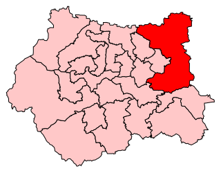
Elmet was a county constituency in West Yorkshire represented in the House of Commons of the Parliament of the United Kingdom. It elected one Member of Parliament (MP) by the first past the post system of election.

Normanton was a county constituency represented in the House of Commons of the Parliament of the United Kingdom. It elected one Member of Parliament (MP) by the first past the post system of election.

Kippax is a village and civil parish in the City of Leeds metropolitan borough, West Yorkshire, England. It is situated to the east of the city, near to Garforth and Great Preston. The Kippax and Methley ward of Leeds City Council was part of the former UK Parliament constituency of Elmet, which became Elmet and Rothwell at the 2010 UK general election. The population of Kippax Parish at the 2011 Census was 9,785. Kippax was a separate civil parish, in Tadcaster Rural District, until 1939, when it was annexed to Garforth. It re-acquired civil parish status and a parish council on 1 April 2004.

Great Preston is a small rural village in the City of Leeds metropolitan borough, West Yorkshire, England. It is situated 9 miles south east of Leeds city centre and is 2 miles south of the town, Garforth. The villages of Allerton Bywater, Kippax, Swillington and Little Preston are also in close proximity. The village is in the LS26 Leeds postcode area, and forms part of the civil parish of Great and Little Preston, which had a population of 1,463 at the 2011 Census.

Elmet and Rothwell is a constituency in West Yorkshire represented in the House of Commons of the UK Parliament since its creation in 2010 by Alec Shelbrooke, a Conservative. In the 2017 general election, Elmet and Rothwell recorded the largest turnout of any seat in West or South Yorkshire, with almost 60,000 electors casting a vote.

Swillington is a village and civil parish near Leeds, West Yorkshire, England, in the City of Leeds metropolitan borough. It is situated 5 miles (8 km) east from Leeds city centre, east from the River Aire, and is surrounded by streams including Fleakingley Beck. In 2001, Swillington had a population of about 3,530, reducing to 3,381 at the 2011 Census.
Lawns is a district of Wakefield in West Yorkshire, England.

The A642 is an A-road in West Yorkshire, England which runs from Huddersfield to the A64 near Leeds. It partly follows the route of a historic turnpike road, which is evidenced by surviving toll houses.

The Leeds Country Way is a circular long-distance footpath of 62 miles (99 km) around Leeds, West Yorkshire, England. It is never more than 7 miles (11 km) from City Square, Leeds, but is mainly rural with extensive views in the outlying areas of the Leeds metropolitan district. It follows public Rights of Way including footpaths, bridleways and minor lanes, with a few short sections along roads.

Ferry Fryston is a suburb of the town of Castleford in West Yorkshire, England. It is situated in the metropolitan borough of the City of Wakefield. The appropriate ward is called Airedale and Ferry Fryston.

Brown Moor is an area in the metropolitan borough of the City of Leeds in West Yorkshire, England, east of Austhorpe and north of Colton Common. The M1 motorway and the A63 road pass it on its eastern flank and the A6120 road in the south. The area is named after a nearby hill. A colliery operated here in the 19th century and was accessed by a spur off the Leeds and Selby Railway, but was already disused in the early 20th century. At that time, some cottages had been erected nearby. Those had been sold by 2002 when Thorpe Park Business Park was established in the area.

Painthorpe is a residential area in the Wakefield District, in the English county of West Yorkshire. It is situated southwest of Crigglestone.

Stanley railway station on the Methley Joint Railway served the village of Stanley east of Outwood, Wakefield, West Yorkshire.

Great and Little Preston is a civil parish in the City of Leeds metropolitan borough, West Yorkshire, England. In 2001 census it had a population of 1,449, and 1463 in the 2011 census. It sits within the Leeds City Council ward of Garforth and Swillington.

Garforth and Swillington is an electoral ward of Leeds City Council in east Leeds, West Yorkshire, covering the town of Garforth as well as the villages of Great Preston and Swillington.


