
Warmia is both a historical and an ethnographic region in northern Poland, forming part of historical Prussia. Its historic capitals were Frombork and Lidzbark Warmiński and the largest city is Olsztyn.
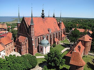
Frombork is a town in northern Poland, situated on the Vistula Lagoon in Braniewo County, within Warmian-Masurian Voivodeship. As of December 2021, it has a population of 2,260.

East Prussia was a province of the Kingdom of Prussia from 1773 to 1829 and again from 1878 ; following World War I it formed part of the Weimar Republic's Free State of Prussia, until 1945. Its capital city was Königsberg. East Prussia was the main part of the region of Prussia along the southeastern Baltic Coast.
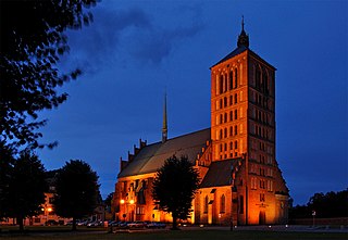
Braniewo, is a town in northern Poland, in Warmia, in the Warmian-Masurian Voivodeship, with a population of 16,907 as of June 2021. It is the capital of Braniewo County.

Royal Prussia or Polish Prussia was a province of the Crown of the Kingdom of Poland, which was established after the Second Peace of Toruń (Thorn) (1466) from territory in Pomerelia and western Prussia which had previously been part of the State of the Teutonic Order. Royal Prussia retained its autonomy, governing itself and maintaining its own laws, customs, rights and German language for German minority.

Warmian–Masurian Voivodeship, also known as Warmia–Masuria Province and Warmia–Mazury Province, is a voivodeship (province) in northeastern Poland. Its capital and largest city is Olsztyn. The voivodeship has an area of 24,192 km2 (9,341 sq mi) and in 2019 had a population of 1,425,967.
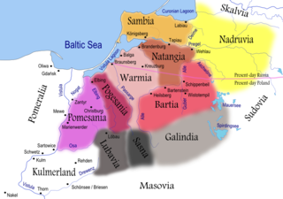
Prussia is a historical region in Europe on the south-eastern coast of the Baltic Sea, that ranges from the Vistula delta in the west to the end of the Curonian Spit in the east and extends inland as far as Masuria. This region is often also referred to as Old Prussia. Tacitus's Germania is the oldest known record of an eyewitness account on the territory and its inhabitants. Pliny the Elder had already confirmed that the Romans had navigated into the waters beyond the Cimbric peninsula (Jutland). Suiones, Sitones, Goths and other Germanic people had temporarily settled to the east and west of the Vistula River during the Migration Period, adjacent to the Aesti, who lived further to the east.

The Province of Prussia was a province of Prussia from 1829 to 1878. Prussia was established as a province of the Kingdom of Prussia in 1829 from the provinces of East Prussia and West Prussia, and was dissolved in 1878 when the merger was reversed.

Reda is a town on the Reda River in northern Poland, in the Kashubia region in Pomerania, with some 26,011 inhabitants. It is part of Wejherowo County, Pomeranian Voivodeship.

South Prussia was a province of the Kingdom of Prussia from 1793 to 1807.

The State of the Teutonic Order was a theocratic state, located along the southeastern shore of the Baltic Sea in northern Europe. It was formed by the knights of the Teutonic Order during the early 13th century Northern Crusades in the region of Prussia. In 1237, the Livonian Brothers of the Sword merged with the Teutonic Order of Prussia and became known as its branch — the Livonian Order. At its greatest territorial extent during the early 15th century, the State encompassed Chełmno Land, Courland, Gotland, Livonia, Estonia, Neumark, Pomerelia, Prussia and Samogitia.
The Prusy Army was one of the Polish armies to fight during the Invasion of Poland in 1939. Created in the summer of 1939 as the main reserve of the Commander in Chief, it was commanded by Gen. Stefan Dąb-Biernacki. The word Prusy in the Polish language means Prussia, but this name only served as a codename and the region of operations of this army was far from East Prussia. This is in contrast to other Polish armies in 1939 which were named after the geographical regions where they formed. The Prusy Army, whose original name was Warszawa Army, was named so after a folwark in central Poland called Prusy, which served as the headquarters of General Dąb-Biernacki.
Polish historic regions are regions that were related to a former Polish state, or are within present-day Poland, with or without being identified in its administrative divisions.

The Archdiocese of Warmia is a Latin Church Metropolitan archdiocese of the Catholic Church in the Warmian-Masurian Voivodeship, Poland.

Leśno is a village in the administrative district of Gmina Brusy, within Chojnice County, Pomeranian Voivodeship, in northern Poland. It lies approximately 8 kilometres (5 mi) north of Brusy, 30 km (19 mi) north of Chojnice, and 77 km (48 mi) south-west of the regional capital Gdańsk. The village is situated on the shores of Leśno Górne and Lesno Dolne lakes.
Wierzchowo is a village in the administrative district of Gmina Człuchów, within Człuchów County, Pomeranian Voivodeship, in northern Poland. It lies approximately 7 kilometres (4 mi) south-east of Człuchów and 116 km (72 mi) south-west of the regional capital Gdańsk. It is located within the historic region of Pomerania.

Dolne Maliki is a village in the administrative district of Gmina Stara Kiszewa, within Kościerzyna County, Pomeranian Voivodeship, in northern Poland. It lies approximately 7 kilometres (4 mi) east of Stara Kiszewa, 23 km (14 mi) south-east of Kościerzyna, and 48 km (30 mi) south-west of the regional capital Gdańsk. It is located within the historic region of Pomerania.
Górne Maliki is a village in the administrative district of Gmina Stara Kiszewa, within Kościerzyna County, Pomeranian Voivodeship, in northern Poland. It lies approximately 6 kilometres (4 mi) east of Stara Kiszewa, 23 km (14 mi) south-east of Kościerzyna, and 49 km (30 mi) south-west of the regional capital Gdańsk. It is located within the historic region of Pomerania.

Mikoszewo is a village in the administrative district of Gmina Stegna, within Nowy Dwór Gdański County, Pomeranian Voivodeship, in northern Poland. It lies approximately 17 kilometres (11 mi) north-west of Nowy Dwór Gdański and 22 km (14 mi) east of the regional capital Gdańsk. Mikoszewo is where the longest Polish river, Vistula, empties into the Baltic Sea. It is located within the historic region of Pomerania.

The Masurian District, also known as the District of East Prussia, and designated as the 4th District, was a district that acted as an provisional administrative division of Poland, during the administration of the Provisional Government of the Republic of Poland in 1945, and the Provisional Government of National Unity from 1945 to 1946. It was centered around the areas of Masuria, Powiśle and Warmia. It was established as one of four provisional districts on 14 March 1945. On 25 September 1945, areas near its western border were incorporated into the Gdańsk Voivodeship, while the areas near its eastern border, to the Białystok Voivodeship. It existed until 28 June 1946, when it was abolished and replaced with the Olsztyn Voivodeship. The head of the district was the attorney-in-fact Stanisław Piaskowski.

