
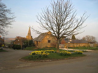
Napton on the Hill is a village and civil parish in the Stratford-on-Avon District of Warwickshire, England. The population of the civil parish taken at the 2021 census was 1,416.

Stratford-on-Avon is a local government district in Warwickshire, England. The district is named after its largest town of Stratford-upon-Avon, but with a change of preposition; the town uses "upon" and the district uses "on". The council is based in Stratford-upon-Avon and the district, which is predominantly rural, also includes the towns of Alcester, Henley-in-Arden, Shipston-on-Stour and Southam, and the large villages of Bidford-on-Avon, Studley and Wellesbourne, plus numerous other smaller villages and hamlets and surrounding rural areas. The district covers the more sparsely populated southern part of Warwickshire, and contains nearly half the county's area. The district includes part of the Cotswolds, a designated Area of Outstanding Natural Beauty.
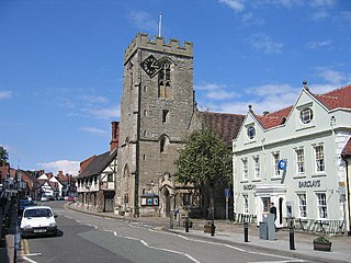
Henley-in-Arden is a market town and civil parish in the Stratford-on-Avon District in Warwickshire, England. The town takes its last name from the former Forest of Arden. Henley is known for its variety of historic buildings, some of which date back to medieval times, and its wide variety of preserved architectural styles. The one-mile-long (1.6 km) High Street is a conservation area.
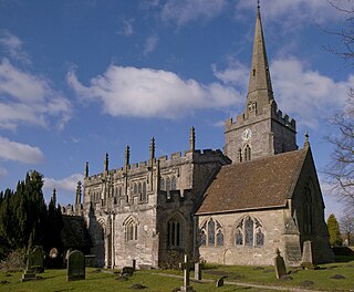
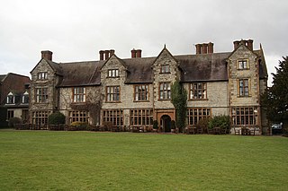
Lapworth is a village and civil parish in Warwickshire, England, which had a population of 2,100 according to the 2001 census; this had fallen to 1,828 at the 2011 Census. It lies seven miles (11 km) south of Solihull and ten miles (16 km) northwest of Warwick, and incorporates the hamlet of Kingswood. Lapworth boasts a historic church, the Church of St Mary the Virgin, a chapel. Two National Trust sites are nearby: Baddesley Clinton, a medieval moated manor house and garden located in the village of Baddesley Clinton; and Packwood House, a Tudor manor house and yew garden with over 100 trees in Packwood.

Wilmcote is a village, and since 2004 a separate civil parish, in the English county of Warwickshire, about 3 miles (5 km) north of Stratford-upon-Avon. Prior to 2004, it was part of the same parish as Aston Cantlow, and the 2001 population for the whole area was 1,670, reducing to 1,229 at the 2011 Census.

Aston Cantlow is a village in Warwickshire, England, on the River Alne 5 miles (8.0 km) north-west of Stratford-upon-Avon and 2 miles (3.2 km) north-west of Wilmcote, close to Little Alne, Shelfield, and Newnham. It was the home of Mary Arden, William Shakespeare's mother. At the 2001 census, it had a population of 1,674, being measured again as 437 at the 2011 Census.

Barcheston is a village and civil parish in the Stratford-on-Avon district of Warwickshire, England. The village is on the east bank of the River Stour, opposite Shipston-on-Stour. It shares a parish council with Willington. The parish, administered at its lowest level by the Barcheston and Willington Parish Meeting, is in the Ettington ward of the district council. According to the 2001 Census the parishes population was 134, increasing to 141 at the 2011 Census.
Billesley is a village and civil parish in the Stratford district of Warwickshire, England, between Stratford and Alcester. According to the 2001 Census, the parish had a population of 46.
Binton is a village and civil parish in the Stratford district of Warwickshire, England. It is about five miles (8.0 km) west of Stratford-upon-Avon. According to the 2001 census it had a population of 272, increasing to 311 at the 2011 census.

Priors Hardwick is a village and civil parish in the Stratford district of Warwickshire, England. The population of the civil parish as taken at the 2011 census was 172. The name derives from the fact that it was originally a manor belonging to the Priors of Coventry.
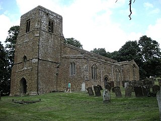
Burton Dassett is a parish and shrunken medieval village in the Stratford-upon-Avon district of Warwickshire, England. The population of the civil parish at the 2011 census was 1,322. Much of the area is now in the Burton Dassett Hills country park. It was enclosed for sheep farming by Sir Edward Belknap and John Heritage at the end of the 15th century. It was the home of Sir Thomas Temple as a child, and for several generations was regarded by the Temple family of Stowe Buckinghamshire as their ancestral home. There is a heraldic memorial to John Temple and his children in Burton Dassett church. Each of the twelve shields represents one of John Temple's children. The left half of each shield represents the husband and the right half represents the wife. The twelfth (undivided) shield represents Temple's son George who died young and therefore did not marry. Susannah Smith, the wife of agriculturalist Jethro Tull was born in the village. Previously known as Chipping Dassett due to its relatively large and successful market.

Coughton is a village and civil parish between Studley 2.4 miles (4 km) to the north and Alcester, 2 miles (3 km) to the south, in the county of Warwickshire, England. The village lies 17 miles (27 km) south of Birmingham on the Birmingham–Alcester A435 road, which here follows the line of the Roman road, Icknield Street. The village is primarily noted as being the location of the National Trust property, Coughton Court, which lies 400 yards to the east of the A435. The population of the parish according to national censuses was 139 in 2001, increasing to 157 in 2011 and 169 in 2021.
Luddington is a small village and civil parish in the English county of Warwickshire and is part of Stratford-on-Avon district. The community is a conservation area due to its historic aspects. In 2001, the population was 457, increasing to 515 at the 2021 census. It is located about 5 kilometres outside the town of Stratford-upon-Avon on the banks of the river Avon and has views south over the Cotswolds. Facilities and communications include a phone box, a 19th-century church, a post box, a marina with a 17th-century lock, a village green and a recently refurbished village hall originally built in 1953. The parish encompasses Dodwell Caravan Park to the north of the village. The village is reputed to be the meeting place of Anne Hathaway and William Shakespeare, as Anne was from the parish, and local lore states that they probably conducted their courtship in the area.
Whitchurch is a parish and a small hamlet lying on the left bank of the River Stour in Warwickshire, England, some four miles south-south-east of the town of Stratford-upon-Avon.
Butlers Marston is a village and civil parish on the River Dene in south-eastern Warwickshire, England. The village is part of Stratford-on-Avon district. In the 2001 census it had a population of 226, increasing to 232 in the 2011 Census. Butlers Marston is located one mile south-west of Kineton and roughly four miles south-east of Wellesbourne.
Wolverton is a village and civil parish in the Stratford-on-Avon District of Warwickshire, England. The population at the 2011 census was 212.

Great Wolford is a village and civil parish in the Stratford-on-Avon district of Warwickshire, England. With the neighbouring parish of Little Wolford it is part of 'The Wolfords'.

Honington, Warwickshire is a hamlet and civil parish in the Stratford-on-Avon District of Warwickshire, England. It is in the Brailes division of the hundred of Kington, and approximately two miles north of Shipston-on-Stour. The population taken at the 2011 census was 250. The River Stour flows past the village on the western side and has a 5-arched 17th-century bridge crossing it. Honington contains approximately 60 houses within the parish boundary, including the half-timbered Magpie Cottage, and Shoemaker's Cottage situated on the Green opposite the gates and lodge entrance to Honington Hall which was built in 1682 by Sir Henry Parker. The Church of All Saints has been re-built, but retains a 13th-century tower.
Shotteswell is a village and civil parish in the Stratford-on-Avon district of Warwickshire. The population of the civil parish at the 2011 census was 221. The parish is bounded on three sides by Oxfordshire and is about 4 miles (6 km) north-west of Banbury.

Charlecote is a small village and civil parish 5 miles (8.0 km) south of Warwick, on the River Avon, in the Stratford-on-Avon district, in the county of Warwickshire, England. In 2011 the parish had a population of 194. The parish touches Wasperton, Newbold Pacey, Wellesbourne and Walton, Stratford-upon-Avon, Loxley and Hampton Lucy. Most of the village is a conservation area. The soil is rich loam and lies on gravel and sand.
