Related Research Articles
This article concerns the systems of transportation in Laos. Laos is a country in Asia, which possesses a number of modern transportation systems, including several highways and a number of airports. As a landlocked country, Laos possesses no ports or harbours on the sea, and the difficulty of navigation on the Mekong means that this is also not a significant transport route.
The Tha River(Nam Tha) is a river in northwest Laos, and one of the 12 tributaries on the Mekong River. It gave its name to the town of Luang Namtha and the province of the same name. The name Nam Tha (ນໍ້າທາ) means 'Green River', coming from the color of the water in the river.


Sainyabuli, is the capital of Sainyabuli Province, Laos. It lies on Route 4 which along with Route 13 connects it to Luang Prabang, roughly 80 kilometres northeast by road and to the Thai border across the Luang Prabang Range in the southwest. A passport control point is in the area. Sainyabuli Airport lies southwest of the town.
Pakbeng is a small village in Laos, on the Mekong River about halfway between the Thai border at Huay Xai and Luang Prabang, Laos. Pakbeng is connected by a sealed road with Oudomxai along the Nam Beng River.

The Kuang Si Falls or Kuang Xi Falls, alternatively known as the Tat Kuang Si Waterfalls, is a three-tiered waterfall about 29 kilometers (18 mi) south of Luang Prabang. The waterfalls are a favorite side trip for tourists in Luang Prabang, and begin in shallow pools atop a steep hillside. These lead to the main fall with a drop of 60 meters (200 ft).
Pha Oudom is a district (muang) of Bokeo province in northwestern Laos. The district, along with Pak Tha district, was part of Oudomxay province until 1992.

Or Lam is a mildly spicy, slightly tongue numbing, Laotian stew originating from Luang Prabang, Laos. The peppery and thick broth is prepared by slowly simmering lemongrass, chilies and Lao chili wood (sakhaan) with crushed or mashed up sticky rice, grilled citronella, garlic, dill and onions added to thicken the broth.
Vieng Phouka, is a town in Luang Namtha Province, northeastern Laos, approximately 50 kilometres southwest of the town of Luang Namtha. It is the capital of Viengphoukha District. The town was affected by the 2007 Laos earthquake, the epicentre only being several kilometres to the southwest.

Muang Sing is a small town and district (muang) in Luang Namtha Province, northwestern Laos, about 60 kilometres northwest of the town of Luang Namtha and 360 kilometres northwest of Vientiane. It lies very close to the border with Yunnan, China, surrounded by mountains and rivers. Historically, Muang Sing has been a major producer of opium and still has problems with drugs and smuggling, due to its proximity to China and Myanmar.

Ban Nam Di is a village in Luang Namtha Province, Laos, located about 6 kilometres (3.7 mi) northeast of Luang Namtha. It has a population of about 500. The Nam Di River flows nearby and the Nam Di waterfall is about a 1 kilometre (0.62 mi) from the village. The village is famous for its bamboo paper making by the Lanten peoples. The locals are adept at turning bamboo into pulp on the river banks and making paper by spreading it thinly over square cotton screens. The paper is usually primarily for Taoist religious purposes, but in recent years the villagers have been producing it as souvenirs for tourists. The houses in the village are mainly made with bamboo roofs.

Ban Phanom is a village in Luang Prabang Province, Laos. It is located 6 kilometres (3.7 mi) east of Luang Prabang. The Lue peoples of this village are noted in particular for their cotton and silk weaving. Sale to tourists is now of prime importance to the local economy. Nearby is the Tomb of Mouhot, where Henri Mouhot lies.
Ban Xang Khong or Ban Sang Khong is a village in Luang Prabang Province, Laos. It is located about 5 kilometres (3.1 mi) east of Luang Prabang. The Lue peoples of this village are noted in particular for their arts and crafts. The locals are adept at making traditional Saa paper, which is made from mulberry trees. There are several bamboo bridges in the area, and the village can be approached on foot from Luang Prabang.
The Tat Sae Waterfalls, also referred to as the Tad Sae Waterfalls are waterfalls located along a tributary of the Nam Khan River in Luang Prabang Province, Laos. They are located about 18 kilometres (11 mi) southeast of Luang Prabang and about 2 kilometres (1.2 mi) from the village of Bak En. The falls flow over limestone formations amongst trees.
Sila is a Loloish language spoken by 2,000 people in Laos and Vietnam. Sila speakers are an officially recognized group in Vietnam, where they are known as the Si La.

Bokèo is a northern province of Laos. It is the smallest and least populous province in the country. Bokeo province covers an area of 6,196 square kilometres (2,392 sq mi). Bokeo province borders Luang Namtha province to the northeast, Oudomxai province to the east, Xaignabouli province to the south, and Thailand to the southwest and Burma to the west and northwest. The province has five districts: and The provinnce has Golden Triangle Special Economic Zone in Ton Pheung district. It is rich in deposits of precious and semiprecious stones. Bokeo's provincial capital is Houayxay on the Mekong River. The province is in the Golden Triangle, at the border of Myanmar and Thailand. There are 34 ethnic groups in the province. Houay Xay is the border town with Thailand and regional economic centre.
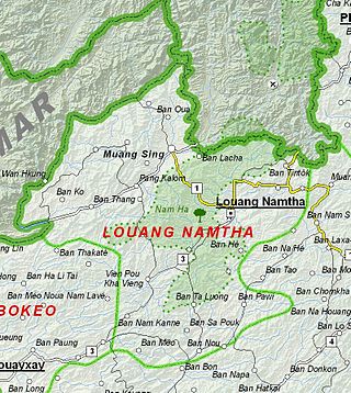
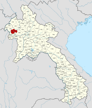
Luang Namtha is a province of Laos in the country's north. From 1966 to 1976 it formed, together with Bokeo, the province of Houakhong. Luang Namtha province covers an area of 9,325 square kilometres (3,600 sq mi). Its provincial capital is Luang Namtha. The province borders Yunnan, China to the north, Oudomxai province to the east and southeast, Bokeo province to the southwest, and Shan State, Myanmar to the northwest.
The Battle of Luang Namtha, fought between January 1962 and May 1963, was a series of clashes in the Laotian Civil War. It came about as a result of the turmoil following Laotian independence as a result of the First Indochina War with France. The Kingdom of Laos had foreign soldiers on its soil, and a political struggle in progress concerning those outside troops. Following a coup and counter-coup that left General Phoumi Nosavan in charge, the general decided on military action to settle the political issue of interlopers in Laos.
Nam Ha National Protected Area is a national protected area in Luang Namtha Province in northern Laos. This mostly forested park is home to a variety of ethnic groups and diverse animal and plant species. The park is an ecotourism destination.
The following lists events that happened during 1962 in Laos.
References
- ↑ DK TRAVEL GUIDES (1 June 2011). DK Eyewitness Travel Guide: Cambodia & Laos. Dorling Kindersley Limited. p. 180. ISBN 978-1-4053-4985-7 . Retrieved 20 July 2012.
- ↑ "Luang Namtha Museum". Lonely Planet . Retrieved 20 July 2012.[ permanent dead link ]
- ↑ "Luang Namtha Museum". Luangnamtha-tourism.org. Retrieved 20 July 2012.[ permanent dead link ]
21°00′21″N101°24′29″E / 21.005786°N 101.408186°E
| | This article about a building or structure in Laos is a stub. You can help Wikipedia by expanding it. |
| | This article related to a museum in Asia is a stub. You can help Wikipedia by expanding it. |