
Fürstenried West is an U-Bahn station in Munich on the U3.
Tadwai is a village and a mandal in Kamareddy district in the state of Telangana in India, located between Kamareddy and Nijamsagar.

Rytebłota is a village in the administrative district of Gmina Zbiczno, within Brodnica County, Kuyavian-Pomeranian Voivodeship, in north-central Poland. It lies 3 kilometres (2 mi) north-east of Zbiczno, 12 km (7 mi) north of Brodnica, and 64 km (40 mi) north-east of Toruń.
Kowalewko-Folwark is a village in the administrative district of Gmina Kcynia, within Nakło County, Kuyavian-Pomeranian Voivodeship, in north-central Poland.
Pieczonka is a settlement in the administrative district of Gmina Supraśl, within Białystok County, Podlaskie Voivodeship, in north-eastern Poland. It lies approximately 10 kilometres (6 mi) east of Supraśl and 25 km (16 mi) north-east of the regional capital Białystok.
Wyłudy is a village in the administrative district of Gmina Korycin, within Sokółka County, Podlaskie Voivodeship, in north-eastern Poland. It lies approximately 15 kilometres (9 mi) east of Korycin, 26 km (16 mi) west of Sokółka, and 41 km (25 mi) north of the regional capital Białystok.
Doły Brzeskie is a village in the administrative district of Gmina Grabica, within Piotrków County, Łódź Voivodeship, in central Poland.
Cierchy is a village in the administrative district of Gmina Mniów, within Kielce County, Świętokrzyskie Voivodeship, in south-central Poland. It lies approximately 4 km (2 mi) south of Mniów and 15 km (9 mi) north-west of the regional capital Kielce.
Stanisławice is a village in the administrative district of Gmina Kozienice, within Kozienice County, Masovian Voivodeship, in east-central Poland. It lies approximately 7 kilometres (4 mi) west of Kozienice and 79 km (49 mi) south-east of Warsaw.
Dosin is a village in the administrative district of Gmina Serock, within Legionowo County, Masovian Voivodeship, in east-central Poland. It lies approximately 6 kilometres (4 mi) south-west of Serock, 11 km (7 mi) north-east of Legionowo, and 30 km (19 mi) north of Warsaw.
Brzezinki is a village in the administrative district of Gmina Pionki, within Radom County, Masovian Voivodeship, in east-central Poland.
Famułki Brochowskie is a village in the administrative district of Gmina Brochów, within Sochaczew County, Masovian Voivodeship, in east-central Poland. It lies approximately 7 kilometres (4 mi) east of Brochów, 13 km (8 mi) north-east of Sochaczew, and 46 km (29 mi) west of Warsaw.

Sawice-Wieś is a village in the administrative district of Gmina Repki, within Sokołów County, Masovian Voivodeship, in east-central Poland.
Mała Gmina is a village in the administrative district of Gmina Szczytniki, within Kalisz County, Greater Poland Voivodeship, in west-central Poland.
Niedźwiadek is a village in the administrative district of Gmina Linia, within Wejherowo County, Pomeranian Voivodeship, in northern Poland. It lies approximately 11 kilometres (7 mi) east of Linia, 17 km (11 mi) south-west of Wejherowo, and 38 km (24 mi) west of the regional capital Gdańsk.
Targowisko Górne is a village in the administrative district of Gmina Lubawa, within Iława County, Warmian-Masurian Voivodeship, in northern Poland. It lies approximately 17 km (11 mi) south-east of Iława and 62 km (39 mi) south-west of the regional capital Olsztyn.
Malinowo is a village in the administrative district of Gmina Olsztynek, within Olsztyn County, Warmian-Masurian Voivodeship, in northern Poland.
Bonin is a village in the administrative district of Gmina Choszczno, within Choszczno County, West Pomeranian Voivodeship, in north-western Poland. It lies approximately 5 kilometres (3 mi) north-west of Choszczno and 57 km (35 mi) south-east of the regional capital Szczecin.
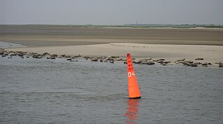
The Wichter Ee is a gat between the East Frisian Islands of Norderney and Baltrum.

Great Ancoats Street is a street in the inner suburb of Ancoats, Manchester, England. Much of Great Ancoats Street was originally named Ancoats Lane and was the location of Ancoats Hall. The street passed through a thriving manufacturing area during the 19th century. It was in close proximity to the Ashton and Rochdale canals. A number of cotton mills built in the early and mid-Victorian period are nearby, some of which have been converted into residential or office buildings, such as Albion Mills. The Pin Mill Works at the junction with Fairfield Street was a late 18th-century pin works, that became a cotton mill run by J & J Thompson and works for dyeing and calico-printing. Brownsfield Mill, a Grade II* listed building, was built in 1825.

