
The North Shore is one of the major geographical regions of Auckland, the largest city in New Zealand. The area is defined as the northern shores of the Waitematā Harbour as far north as the Ōkura River.

East Coast Bays is a string of small suburbs that form the northernmost part of the North Shore, part of the contiguous Auckland metropolitan area in New Zealand. The suburbs line the north-east coast of the city along the shore of the Hauraki Gulf and Rangitoto Channel. They include, from north to south, Long Bay, Torbay, Waiake Bay, Browns Bay, Rothesay Bay, Murrays Bay, Mairangi Bay, Campbells Bay and Castor Bay. Most of the East Coast Bays are covered under the East Coast Bays subdivision of the Hibiscus and Bays local board area.

Glenfield is a suburb of Auckland, New Zealand, located on the North Shore. Established as a rural community in the 1850s, the area developed as a suburban part of Auckland after the completion of the Auckland Harbour Bridge in 1959.

Albany is one of the northernmost suburbs of the contiguous Auckland metropolitan area in New Zealand. It is located on the North Shore, 15 kilometres (9 mi) northwest of the Auckland city centre. Albany is found at the headlands of Lucas Creek, and was the location of a portage used by Tāmaki Māori, where waka could be taken between the Upper Waitematā Harbour and the Okura River/Hauraki Gulf. During the 1840s, early European settlers established the village of Lucas Creek, which became by the 1880s had become a major fruit growing centre in Auckland. The town voted to change the name from Lucas Creek to Albany in 1890.

Pāremoremo is a rural settlement and its mostly rural surrounds about 8 km southwest of Albany on the northern fringe of Auckland, New Zealand. Coatesville is about 7 km to the north, and Riverhead is about 8 km to the west. Pāremoremo is home to New Zealand's only maximum security prison.

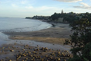
Browns Bay is one of the most northernmost suburbs in the contiguous Auckland metropolitan area, located in the North Shore. Named after the Brown family who settled here in 1876, Browns Bay became a holiday destination in the late 19th century. The area gradually developed into a suburb of Auckland in the 1950s, and was the administrative centre for the East Coast Bays City from 1975 until it was disestablished in 1989. During the 1990s, the suburb became a hub for the South African New Zealander community.

Greenhithe is a northwestern suburb of Auckland, New Zealand, located on the North Shore. Greenhithe was the location of Tauhinu, a fortified Te Kawerau ā Maki and Ngāti Whātua pā which overlooked the entrance to Oruamo or Hellyers Creek, that was settled until the 1820s. In the 1860s, the Forgham family established a community at Greenhithe, which by the 1880s had become a major fruit producer for Auckland. Boat repair and construction became major industries in Greenhithe in the 1960s.
Torbay is a northern suburb of Auckland, New Zealand. It is located in the upper East Coast Bays of the city's North Shore, and is governed by Auckland Council.

Rothesay Bay is a small suburb in Auckland's East Coast Bays region. The suburb is roughly the same size as Murrays Bay, the suburb to the immediate south.
Murrays Bay is a small suburb in the East Coast Bays region, located in the North Shore of Auckland. The suburb is roughly the same size as Rothesay Bay, the suburb to the immediate north. It is primarily a residential area but does have a community centre, restaurant and café. Murrays Bay is regularly serviced by buses which go to Takapuna and the Auckland city centre.

Long Bay is one of the northernmost suburbs of the North Shore, part of the contiguous Auckland metropolitan area located in New Zealand.

Long Bay College is a state co-educational secondary school located in Torbay, a suburb of the North Shore in Auckland, New Zealand. The decile 10 school serves Years 9 to 13, and has 1782 students as of August 2024. Christopher (CJ) Healey is the school's current principal. Long Bay College has a large zone boundary including the upper east coast bays, Brookfield, Albany, Albany heights, Redvale, Coatesville, Paremoremo and Brighams creek.
Campbells Bay is a suburb of the North Shore located in Auckland, New Zealand.

Wairau Valley is a suburb of Auckland, New Zealand. The area is predominantly light industrial/commercial. The Northern Motorway passes to the east, and the Wairau Park shopping complex extends to the north. The valley is drained by the Wairau Creek, which flows on through Milford and discharges into the Hauraki Gulf from an estuary at the northern end of Milford Beach.

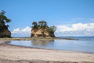
Waiake is one of the northernmost suburbs of the North Shore, in Auckland, New Zealand. It is located in the East Coast Bays between the suburbs of Browns Bay to the south and Torbay to the north. It has a beach, which looks out to the Tor, a presque-isle at the north end of the beach that becomes an island at high tide. Waiake is under the local governance of the Auckland Council.

Schnapper Rock is a western suburb on the North Shore of Auckland, New Zealand. The suburb is currently under local governance of Auckland Council. The area was known for a gum digging hut used by early European settlers in the mid-19th century. North Shore Memorial Park was opened area in 1974, and the area developed into suburban housing in the early 2000s.

Upper Harbour is a local government area in Auckland, in New Zealand's Auckland Region, governed by the Upper Harbour Local Board and Auckland Council. It currently aligns with the council's Albany Ward.

Oruamo or Hellyers Creek is a stream and tidal estuary of Upper Waitematā Harbour in the Auckland Region of New Zealand's North Island. It flows through the western North Shore.

The Upper Waitematā Harbour is an estuary of the Waitematā Harbour in the Auckland Region of New Zealand. It flows south-east from the town of Riverhead, and was historically the border between Waitakere City and North Shore City in Auckland.

Lucas Creek is a stream and tidal estuary of Upper Waitematā Harbour in the Auckland Region of New Zealand's North Island. It flows through Albany on the western North Shore, and enters the Upper Waitematā Harbour between Pāremoremo and Greenhithe.

