
The Broads is a network of mostly navigable rivers and lakes in the English counties of Norfolk and Suffolk. The lakes, known as broads, were formed by the flooding of peat workings. The Broads, and some surrounding land, were constituted as a special area with a level of protection similar to a national park by the Norfolk and Suffolk Broads Act 1988. The Broads Authority, a special statutory authority responsible for managing the area, became operational in 1989.

Wroxham is a village and civil parish in the English county of Norfolk. The civil parish of Wroxham has an area of 6.21 square kilometres and in 2001 had a population of 1532 in 666 households, reducing to a population of 1,502 in 653 households at the 2011 Census. The village is situated within the Norfolk Broads on the south side of a loop in the middle reaches of the River Bure. It lies in an elevated position above the Bure, between Belaugh Broad to the west and Wroxham Broad to the east or south east. Wroxham is some eight miles north-east of Norwich, to which it is linked by the A1151 road. The village and broad lie in an area of fairly intensive agriculture, with areas of wet woodland adjoining the broad and river. For the purposes of local government, the parish falls within the district of Broadland although the river, broad and their immediate environs fall within the executive area of the Broads Authority. On the northern side of the Bure is the village of Hoveton, often confused with Wroxham.

The River Waveney is a river which forms the boundary between Suffolk and Norfolk, England, for much of its length within The Broads. The "ey" part of the name means "river" thus the name is tautological.

Potter Heigham is a village and civil parish on the River Thurne in the English county of Norfolk. It is situated 12 mi (19 km) north-east of the city of Norwich on the A149 road, and within the Broads.

Trinity Broads is a 316.8-hectare (783-acre) biological Site of Special Scientific Interest north of Great Yarmouth in Norfolk. They are in The Broads Special Area of Conservation. They are also part of the Broads National Park in Norfolk, England, comprising 5 broads in total. The three largest are Rollesby Broad, Ormesby Broad and Filby Broad, and there are two much smaller broads named Lily Broad and Ormesby Little Broad. They are managed by the Broads Authority.

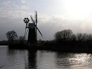
How Hill is a hamlet on the River Ant within The Broads National Park in Ludham parish, Norfolk, England.

Wroxham Broad is an area of open water alongside the River Bure near the village of Wroxham in Norfolk, England within The Broads National Park. The Norfolk Broads were formed by the flooding of ancient peat workings. Wroxham Broad has an area of 34.4 hectares and a mean depth of 1.3 metres. It lies to the west of the Bure, with two navigable openings between river and broad. The village and broad lie in an area of fairly intensive agriculture, with areas of wet woodland adjoining the broad and river.

Breydon Water is a 514.4-hectare (1,271-acre) biological Site of Special Scientific Interest at Great Yarmouth, Norfolk. It is a Local Nature Reserve, a Ramsar site and a Special Protection Area. It is part of the Berney Marshes and Breydon Water nature reserve, which is managed by the Royal Society for the Protection of Birds (RSPB).

Berney Arms is a remote settlement on the north bank of the River Yare, close to Breydon Water in the English county of Norfolk. It is part of the civil parish of Reedham, is in the district of Broadland and lies within The Broads. It comprises a railway station, a windmill, a farmhouse and a pub which closed in late 2015. The area is not accessible by public road.

The River Bure is a river in the county of Norfolk, England, most of it in the Broads. The Bure rises near Melton Constable, 11 miles (18 km) upstream of Aylsham, which was the original head of navigation. Nowadays, the head of navigation is 10 miles (16 km) downstream at Coltishall Bridge. After Aylsham Lock and Burgh Bridge, the Bure passes through Buxton Lammas, Coltishall, Belaugh, Wroxham, Horning, Ludham Bridge, past St. Benet's Abbey, through Oby, Acle, Stokesby, along the northern border of the Halvergate Marshes, through Runham and Great Yarmouth where it meets Breydon Water and flows into the sea at Gorleston.
The River Ant is a tributary river of the River Bure in the county of Norfolk, England. It is 27 kilometres (17 mi) long, and has an overall drop of 27 metres from source to mouth. It is said that the Ant was formerly known as the River Smale and that this is the origin of the name of the village of Smallburgh.

The North Walsham and Dilham Canal is a waterway in the English county of Norfolk. It was authorised by Parliament in 1812, but work on the construction of a canal which ran parallel to a branch of the River Ant did not start until 1825. It included six locks, which were sized to accommodate wherries, and was officially opened in August 1826. It was 8.7 miles (14.0 km) long and ran from two bone mills at Antingham to a junction with the River Ant at Smallburgh. It carried offal for the bone mills and agricultural products, as it proved cheaper to land coal on the beach at Mundesley and cart it overland than to use the canal.

The River Thurne is a river in Norfolk, England in The Broads. Just 7 miles (11 km) long, it rises 2 miles (3.2 km) from the coast near Martham Broad and is navigable from West Somerton. It flows southwest and is linked by Candle Dyke and Heigham Sound to both Horsey Mere and Hickling Broad. It continues southwest and flows through Potter Heigham and enters the River Bure just south of Thurne dyke, near St Benet's Abbey.

Broadland is a local government district in Norfolk, England, named after the Norfolk Broads. The population of the local authority district taken at the 2011 Census was 124,646. Its council is based in Thorpe St Andrew, which is a suburb of the city of Norwich.
The ceremonial county of Lincolnshire is the second largest of the English counties and one that is predominantly agricultural in character. Despite its relatively large physical area, it has a comparatively small population. The unusually low population density that arises gives the county a very different character from the much more densely populated an urbanised counties of south-east and northern England, and is, in many ways, key to understanding the nature of the county.

Whitlingham is a small churchless parish and hamlet at the mouth of the River Wensum in Norfolk, England. It is located 3 miles (5 km) east of Norwich, on the south bank of the River Yare, reached from Trowse along Whitlingham Lane.

Wherryman's Way is a long-distance footpath in the English county of Norfolk.

The A146 is an A road that connects Norwich in Norfolk and Lowestoft in Suffolk, two of East Anglia's largest population centres. It is around 27 miles (43 km) in length and has primary classification along its entire route. It is mainly single carriageway throughout its route, with the exception of a section of dual carriageway on the southern edge of Norwich.
Wangford was a hundred of Suffolk, England, consisting of 34,679 acres (140.34 km2).

Heigham Holmes is a national nature reserve located within the Norfolk Broads in the English county of Norfolk. The reserve is, in effect, an island, being surrounded by the river channels, drainage ditches and wetland areas of the Broads. It is only accessible by an unusual floating swing bridge across the River Thurne from the village of Martham.
