
Michałówka is a village in the administrative district of Gmina Piątek, within Łęczyca County, Łódź Voivodeship, in central Poland. It lies approximately 3 kilometres (2 mi) north of Piątek, 20 km (12 mi) east of Łęczyca, and 35 km (22 mi) north of the regional capital Łódź.

Holy Trinity the Less was a parish church in Knightrider Street the City of London, destroyed in the Great Fire of London. Following the fire the site was used for a Lutheran church, which was eventually demolished in 1871 to make way for Mansion House underground station
Brzózki is a village in the administrative district of Gmina Szubin, within Nakło County, Kuyavian-Pomeranian Voivodeship, in north-central Poland. It lies approximately 9 kilometres (6 mi) north of Szubin, 10 km (6 mi) south-east of Nakło nad Notecią, and 19 km (12 mi) west of Bydgoszcz.
Nadkanale is a village in the administrative district of Gmina Szubin, within Nakło County, Kuyavian-Pomeranian Voivodeship, in north-central Poland. It lies approximately 11 kilometres (7 mi) north-east of Szubin, 18 km (11 mi) east of Nakło nad Notecią, and 12 km (7 mi) west of Bydgoszcz.
Pieleszki is a village in the administrative district of Gmina Chodecz, within Włocławek County, Kuyavian-Pomeranian Voivodeship, in north-central Poland.
Knorydy Górne is a village in the administrative district of Gmina Bielsk Podlaski, within Bielsk County, Podlaskie Voivodeship, in north-eastern Poland. It lies approximately 10 kilometres (6 mi) south-west of Bielsk Podlaski and 46 km (29 mi) south of the regional capital Białystok.
Rąblów is a village in the administrative district of Gmina Wąwolnica, within Puławy County, Lublin Voivodeship, in eastern Poland. It lies approximately 14 kilometres (9 mi) south-east of Puławy and 35 km (22 mi) west of the regional capital Lublin.
Kółko Żabieckie is a village in the administrative district of Gmina Pacanów, within Busko County, Świętokrzyskie Voivodeship, in south-central Poland. It lies approximately 7 kilometres (4 mi) south-east of Pacanów, 31 km (19 mi) south-east of Busko-Zdrój, and 69 km (43 mi) south-east of the regional capital Kielce.
Podwale is a village in the administrative district of Gmina Pacanów, within Busko County, Świętokrzyskie Voivodeship, in south-central Poland. It lies approximately 7 kilometres (4 mi) south-west of Pacanów, 25 km (16 mi) south-east of Busko-Zdrój, and 66 km (41 mi) south-east of the regional capital Kielce.
Rybie is a village in the administrative district of Gmina Pacyna, within Gostynin County, Masovian Voivodeship, in east-central Poland. It lies approximately 6 kilometres (4 mi) north of Pacyna, 19 km (12 mi) south-east of Gostynin, and 89 km (55 mi) west of Warsaw.
Szydłówek is a village in the administrative district of Gmina Szydłowo, within Mława County, Masovian Voivodeship, in east-central Poland.
Arciechówek is a village in the administrative district of Gmina Iłów, within Sochaczew County, Masovian Voivodeship, in east-central Poland.
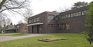
Haus Lange and Haus Esters are residential houses designed by Ludwig Mies van der Rohe in Krefeld, Germany. They were built between 1928 and 1930 in the Bauhaus style. The houses have now been converted into museums for Contemporary art.
Ciosna is a village in the administrative district of Gmina Strzałkowo, within Słupca County, Greater Poland Voivodeship, in west-central Poland. It lies approximately 7 kilometres (4 mi) north-east of Strzałkowo, 6 km (4 mi) north of Słupca, and 67 km (42 mi) east of the regional capital Poznań.
Sokołowo is a village in the administrative district of Gmina Września, within Września County, Greater Poland Voivodeship, in west-central Poland. It lies approximately 2 kilometres (1 mi) north-west of Września and 45 km (28 mi) east of the regional capital Poznań.
Sudoł is a village in the administrative district of Gmina Czerwieńsk, within Zielona Góra County, Lubusz Voivodeship, in western Poland.
Krawusin is a settlement in the administrative district of Gmina Skarszewy, within Starogard County, Pomeranian Voivodeship, in northern Poland. It lies approximately 4 kilometres (2 mi) north of Skarszewy, 16 km (10 mi) north-west of Starogard Gdański, and 33 km (21 mi) south-west of the regional capital Gdańsk.
Čejkovice is a village and municipality in Kutná Hora District in the Central Bohemian Region of the Czech Republic.

Tuleš is a village in the municipality of Aleksandrovac, Serbia. According to the 2002 census, the village has a population of 496 people.
Čardak is a former vacation settlement on the southern edge of the Deliblatska peščara, in the community of Kovin in Serbia. It has served as a refugee camp since 1991. The camp is about five km east of the village of Deliblato in the South Banat District.


