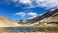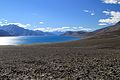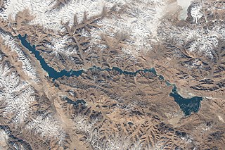
Pangong Tso or Pangong Lake is an endorheic lake spanning eastern Ladakh and West Tibet situated at an elevation of 4,225 m (13,862 ft). It is 134 km (83 mi) long and divided into five sublakes, called Pangong Tso, Tso Nyak, Rum Tso and Nyak Tso. Approximately 50% of the length of the overall lake lies within Tibet in China, 40% in Ladakh, India and the remaining 10% is disputed and is a de facto buffer zone between India and China. The lake is 5 km (3.1 mi) wide at its broadest point. All together it covers almost 700 km2. During winter the lake freezes completely, despite being saline water. It has a land-locked basin separated from the Indus River basin by a small elevated ridge, but is believed to have been part of the latter in prehistoric times.
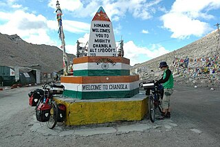
Chang La is a high mountain pass in Ladakh at an elevation of 5,391.3024 m or 17,688.000 ft in the Ladakh Range between Leh and the Shyok River valley. The Chang La, on Leh to Pangong Lake road, lies on the Leh-Karu-Sakti-Zingral-Chang La-Durbuk-Tangtse-Pangong Lake motorable road. Karu, which lies on Leh-Manali NH-3, connects Chang La and Pangong Lake to Leh and the rest of India. In September 2021, BRO opened another alternate motorable asphalt road between Zingral and Tangtse via Ke La pass and Taruk.

Ladakh is an administrative territory of India that has been under its control since 1947. The geographical region of Ladakh union territory is the highest altitude plateau region in India, incorporating parts of the Himalayan and Karakoram mountain ranges and the upper Indus River and valley.

Tourism is one of an economic contributor to the union territory of Ladakh in Northern India. The union territory is sandwiched between the Karakoram mountain range to the north and the Himalayas to the south and is situated at the height of 11,400 ft. Ladakh is composed of the Leh and Kargil districts. The region contains prominent Buddhist sites and has an ecotourism industry.

Tso Moriri or Lake Moriri or "Mountain Lake", is a lake in the Changthang Plateau of Ladakh in India. The lake and surrounding area are protected as the Tso Moriri Wetland Conservation Reserve.

The Shyok River is a tributary of the Indus River that flows through northern Ladakh and enters Gilgit–Baltistan, spanning some 550 km (340 mi).
Himank, also styled Project HIMANK, is a project of the Border Roads Organisation (BRO) in the Ladakh region of northernmost India that started in August 1985. It is known for constructing some of world's highest motorable roads across the Khardung La, Tanglang La and Chang La passes. Umling la is the highest motorable road on Earth with height 5882 metres. It is responsible for constructing and maintaining motorable roads in Ladakh, along the Line of Actual Control. Himank project ensures access to sensitive military areas including the world's highest battleground at the Siachen Glacier and Pangong Tso Lake, whose waters span the de facto India-China border. Nicknamed "The Mountain Tamers", much of Himank's work is constrained to four months per year, as heavy snow and extreme cold make some roads inaccessible at other times. Between 1987 and 2002, at least 124 Himank personnel were killed while on duty in Ladakh, including five officers. Most of its manual labourers are from Bihar state, not Ladakh. They are nicknamed Dumkas, where many of the original Himank workers were recruited.
Chushul is a village in the Leh district of Ladakh, India. It is located in the Durbuk tehsil, in the area known as "Chushul Valley", south of the Pangong Lake and west of the Spanggur Lake. The Line of Actual Control with China runs about 5 miles east of Chushul, across the Chushul Valley. Famous as site for historical battle grounds.

The Tso Kar or Tsho kar is a fluctuating salt lake known for its size and depth situated in the Rupshu Plateau and valley in the southern part of Ladakh in India. It is also recognised as India's 42nd Ramsar site.

The Khurnak Fort is a ruined fort on the northern shore of Pangong Lake, which spans eastern Ladakh in India and Rutog County in the Tibet region of China. The area of the Khurnak Fort is disputed by India and China, and has been under Chinese administration since 1958.
Man Pangong is a village in the Leh district of the Indian union territory of Ladakh. It is located in the Durbuk tehsil, near the Pangong Tso lake.
Tangtse or Drangtse (Tibetan: བྲང་རྩེ, Wylie: brang rtse, THL: drang tsé) is a village in the Leh district of Ladakh, India. It is located in the Durbuk tehsil. Traditionally, it was regarded as the border between the Nubra region to the north and the Pangong region to the south. It was a key halting place on the trade route between Turkestan and Tibet. It was also a site of wars between Ladakh and Tibet.
Durbuk or Darbuk, is a village and the headquarters of the eponymous subdivision and block in the Leh district of Ladakh, India. It is located in the Durbuk tehsil, and falls between Chang La mountain pass and Tangste village on the way to Pangong Tso Lake.

Gya or Gia is a village in the Leh district of Ladakh in India. It is located in the Kharu tehsil, off the Leh–Manali Highway, close to Tso Kar.

Kharu also spelt Karu, is a town, subdivision, tehsil, block, tourist station and military base on the bank of Indus River in the Leh district of Union territory of Ladakh in India. It is located 34 km southeast of Leh on Leh-Manali Highway and under-construction Bhanupli–Leh line. Karu is one of the important railway station and military's railway logistics hub on the under construction Bhanupli–Leh line of Indian Railway. Karu is an important transit point where several strategic and important road arterial and feeder routes of India-China Border Roads meet, such as Leh-Manali Highway, Leh-Nyoma road, Hamis-Karo-Pangong Tso road, etc.
Shyok or Shayok is a village on the bank of the Shyok River in Durbuk tehsil of Leh district in Ladakh, India. It is located at the southern tip of the V-shaped course of the Shyok River, where the Tangtse river joins it from the left. Historically, the winter caravan route from Leh to Yarkand passed through the village. In modern times, India's strategic road to its border post at Daulat Beg Oldi uses the same route.
Phobrang is a settlement in the Indian union territory of Ladakh. It is near Lukung on the way the Indo-China border at the Hot Springs. It is the last village of Ladakh in this direction, at an elevation of 14,500 feet (4,400 m).
Kyagar Tso or Kyagar Lake is a small brackish lake surrounded by mountains situated in the Ladakh region of the northern Indian Union Territory of Ladakh in India. From afar, it can be spotted by its turquoise colour.
Spangmik is a settlement on the southern bank of the Pangong Lake in Ladakh, India. It is located between Lukung and Man. Tourists visiting the Pangong Lake in India are allowed to travel up to Spangmik, beyond which it is considered sensitive border area with China.
Merak is a forward village on the southern banks of Pangong Tso, near Spangmik on the south India-China border in the Leh District, Ladakh.