
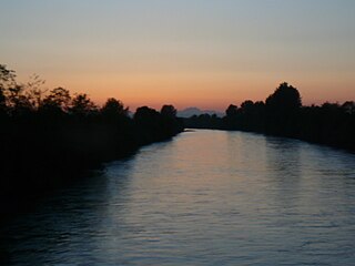
The Sacramento River is the principal river of Northern California in the United States and is the largest river in California. Rising in the Klamath Mountains, the river flows south for 400 miles (640 km) before reaching the Sacramento–San Joaquin River Delta and San Francisco Bay. The river drains about 26,500 square miles (69,000 km2) in 19 California counties, mostly within the fertile agricultural region bounded by the Coast Ranges and Sierra Nevada known as the Sacramento Valley, but also extending as far as the volcanic plateaus of Northeastern California. Historically, its watershed has reached as far north as south-central Oregon where the now, primarily, endorheic (closed) Goose Lake rarely experiences southerly outflow into the Pit River, the most northerly tributary of the Sacramento.

Whatcom County is a county located in the northwestern corner of the U.S. state of Washington, bordered by the Lower Mainland of British Columbia to the north, Okanogan County to the east, Skagit County to the south, San Juan County across Rosario Strait to the southwest, and the Strait of Georgia to the west. Its county seat and largest population center is the coastal city of Bellingham. Whatcom County is coterminous with the Bellingham, WA Metropolitan Statistical Area. As of the 2020 census, the county's population was 226,847.

The River Dearne South Yorkshire, England flows roughly east for more than 30 kilometres (19 mi), from its source just inside West Yorkshire. It flows through Denby Dale, Clayton West, Darton, Barnsley, Darfield, Wath upon Dearne, Bolton on Dearne, Adwick upon Dearne and Mexborough to its confluence with the River Don at Denaby Main. Its main tributary is the River Dove, which joins it at Darfield. The river was one of those affected by the 2007 United Kingdom floods.

The Cedar River is a river in the U.S. state of Washington. About 45 miles (72 km) long, it originates in the Cascade Range and flows generally west and northwest, emptying into the southern end of Lake Washington. Its upper watershed is a protected area called the Cedar River Watershed, which provides drinking water for the greater Seattle area.

The White River is a white, glacial river in the U.S. state of Washington. It flows about 75 miles (121 km) from its source, the Emmons Glacier on Mount Rainier, to join the Puyallup River at Sumner. It defines part of the boundary between King and Pierce counties.

The Salmon River, also known as the "River of No Return", is a river located in the U.S. state of Idaho in the western United States. It flows for 425 miles (685 km) through central Idaho, draining a rugged, thinly populated watershed of 14,000 square miles (36,000 km2). The river drops more than 7,000 feet (2,100 m) from its headwaters, near Galena Summit above the Sawtooth Valley in the Sawtooth National Recreation Area, to its confluence with the Snake River. Measured at White Bird, its average discharge is 11,060 cubic feet per second. The Salmon River is the longest undammed river in the contiguous United States.
The Puyallup River is a river in the U.S. state of Washington. About 45 miles (72 km) long, it is formed by glaciers on the west side of Mount Rainier. It flows generally northwest, emptying into Commencement Bay, part of Puget Sound. The river and its tributaries drain an area of about 948 square miles (2,460 km2) in Pierce County and southern King County.

The Nooksack River is a river in western Whatcom County of the northwestern U.S. state of Washington, draining extensive valley systems within the North Cascades around Mount Shuksan, Mount Baker and the Twin Sisters, and a portion of Fraser Lowland south of the Canada–United States border.

The Waimakariri River is one of the largest rivers in Canterbury, on the eastern coast of New Zealand's South Island. It flows for 151 kilometres (94 mi) in a generally southeastward direction from the Southern Alps across the Canterbury Plains to the Pacific Ocean.

The Payette River is an 82.7-mile-long (133.1 km) river in southwestern Idaho and a major tributary of the Snake River.

Lake Whatcom is located in Whatcom County, Washington, United States. It is the drinking water source for approximately 85,000 residents in the city of Bellingham as well as Whatcom County. It is approximately 10 miles (16 km) in length and 1 mile (1.6 km) in width at its widest. Lake Whatcom is located and managed within three political jurisdictions: the city of Bellingham, Whatcom County, and the Lake Whatcom Water and Sewer District. The lake is a popular area for motor boating, swimming, fishing, and other recreational activities.

The Billy Frank Jr. Nisqually National Wildlife Refuge is a wildlife preserve operated by the United States Fish and Wildlife Service on the Nisqually River Delta near Puget Sound in northeastern Thurston County, Washington and northwestern Pierce County, Washington. The refuge is located just off Interstate 5, between the cities of Tacoma and Olympia.

Bellingham Bay is a bay of the Salish Sea located in Washington State in the United States. It is separated from the Strait of Georgia on the west by the Lummi Peninsula, Portage Island, and Lummi Island. It is bordered on the east by Bellingham, Washington, to the south-east by the Chuckanut Mountains, and to the south by Samish Bay. The Nooksack River empties into the bay, as does Whatcom Creek.

The Pilchuck River is a river in Snohomish County in the U.S. state of Washington. It is a tributary of the Snohomish River. The name is derived from the Chinook Jargon pilpil and chuck ("water"), or "red water". The Lushootseed name means "flowing red," kʷiƛ̕ being an archaic term for "red" in Northern Lushootseed.
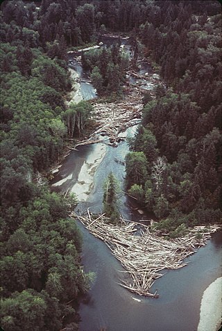
A log jam is a naturally occurring phenomenon characterized by a dense accumulation of tree trunks and pieces of large wood across a vast section of a river, stream, or lake. Log jams in rivers and streams often span the entirety of the water's surface from bank to bank. Log jams form when trees floating in the water become entangled with other trees floating in the water or become snagged on rocks, large woody debris, or other objects anchored underwater. They can build up slowly over months or years, or they can happen instantaneously when large numbers of trees are swept into the water after natural disasters. A notable example caused by a natural disaster is the log jam that occurred in Spirit Lake following a landslide triggered by the eruption of Mount St. Helens. Unless they are dismantled by natural causes or humans, log jams can grow quickly, as more wood arriving from upstream becomes entangled in the mass. Log jams can persist for many decades, as is the case with the log jam in Spirit Lake.

Salmon Falls Creek is a tributary of the Snake River, flowing from northern Nevada into Idaho in the United States. Formed in high mountains at the northern edge of the Great Basin, Salmon Falls Creek flows northwards 121 miles (195 km), draining an arid and mountainous basin of 2,103 square miles (5,450 km2). The Salmon Falls Creek valley served as a trade route between the Native American groups of the Snake River Plain and Great Basin. Today, most of its water is used for irrigation.

Whatcom Creek is a waterway in Bellingham, Washington, United States.

Cottonwood Creek is a major stream and tributary of the Sacramento River in Northern California. About 68 miles (109 km) long measured to its uppermost tributaries, the creek drains a large rural area bounded by the crest of the Coast Ranges, traversing the northwestern Sacramento Valley before emptying into the Sacramento River near the town of Cottonwood. It defines the boundary of Shasta and Tehama counties for its entire length. Because Cottonwood Creek is the largest undammed tributary of the Sacramento River, it is known for its Chinook salmon and steelhead runs.

Du Poète Lake is a freshwater lake that has become the "Du Poète Reservoir", located west of the Gouin Reservoir, in the territory of the city of La Tuque, in the administrative region of Mauricie, in the province of Quebec, in Canada. This lake extends entirely in the canton of Poisson.

The Lummi are a Central Coast Salish people Indigenous to western Washington, namely parts of the San Juan Islands and the mainland near what is now Bellingham, Washington.
