Lun, Croatia

Last updated
Lun
Village
Uvala Tovrnele, Lun, otok Pag - camci.jpg
The port of Lun
Croatia location map.svg
Red pog.svg
Lun
Coordinates: 44°41′28″N14°44′14″E / 44.69103°N 14.73720°E / 44.69103; 14.73720
CountryFlag of Croatia.svg  Croatia
County Flag of Lika-Senj County.svg Lika-Senj
Town Novalja
Area
[1]
  Total8.6 km2 (3.3 sq mi)
Population
 (2021) [2]
  Total148
  Density17/km2 (45/sq mi)
Time zone UTC+1 (CET)
  Summer (DST) UTC+2 (CEST)

Lun is a village in Lika-Senj County, Croatia, and the northernmost village of the Adriatic island of Pag. In the 2021 census, the village had a population of 148. [2]

Contents

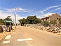
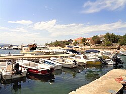
Lun is accessible from Novalja by automobile via the main road or from Rab via the Lun-Rab Passenger Ferry. The main village of Lun is situated about half a mile up the hill from the coast. Its port area is named Tovarnele.

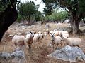
The predominant occupation of its inhabitants in the summer months is keeping bed and breakfasts and restaurants for seasonal tourists. Additional family support is provided by fishing, and farming sheep, grapes, and olives.

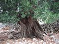
Lun is known for its extensive olive garden, which contains thousands of ancient olive trees, including one that is claimed to be 2000 years old and another that is claimed to be 1600 years old. The garden also includes one of the world's largest collections of wild olive trees. [3]

Related Research Articles

<span class="mw-page-title-main">Dalmatia</span> Historical region of Croatia

Dalmatia is one of the four historical regions of Croatia, alongside Central Croatia, Slavonia and Istria, located on the east shore of the Adriatic Sea in Croatia.

<span class="mw-page-title-main">Fresno, California</span> City in California, United States

Fresno is a major city in the San Joaquin Valley of California, United States. It is the county seat of Fresno County and the largest city in the greater Central Valley region. It covers about 115 square miles (300 km2) and had a population of 542,107 as of the 2020 Census, making it the fifth-most populous city, in California, the most populous inland city in California, and the 34th-most populous city in the nation.

<span class="mw-page-title-main">Gethsemane</span> Garden by Jerusalems Mount of Olives

Gethsemane is a garden at the foot of the Mount of Olives in East Jerusalem where, according to the four Gospels of the New Testament, Jesus Christ underwent the agony in the garden and was arrested before his crucifixion. It is a place of great resonance in Christianity. There are several small olive groves in church property, all adjacent to each other and identified with biblical Gethsemane.

<span class="mw-page-title-main">Istria County</span> County in western Croatia

Istria County is the westernmost county of Croatia which includes the majority of the Istrian peninsula.

<span class="mw-page-title-main">Rab (island)</span> Island in Croatia

Rab [ɾâːb] is an island in the northern Dalmatia region in Croatia, located just off the northern Croatian coast in the Adriatic Sea.

<span class="mw-page-title-main">Lairg</span> Human settlement in Scotland

Lairg is a village and parish in Sutherland, Scotland. It has a population of 891 and is at the south-eastern end of Loch Shin.

<span class="mw-page-title-main">Skopelos</span> Municipality in Greece

Skopelos is a Greek island in the western Aegean Sea. Skopelos is one of several islands which comprise the Northern Sporades island group, which lies east of the Pelion peninsula on the mainland and north of the island of Euboea. It is part of the Thessaly region. Skopelos is also the name of the main port and the municipal center of the island. The other communities of the island are Glossa and Neo Klima (Elios). The geography of Skopelos includes two mountains over 500 m (1,640 ft); Delphi (681 m/2,234 ft) in the center of the island, and Palouki in the southeast. With an area of 96 km2 (37 sq mi) Skopelos is slightly larger than Mykonos (85 km2/33 sq mi) and Santorini (73 km2/28 sq mi). The nearest inhabited islands are Skiathos to the west and Alonnisos to the east.

<span class="mw-page-title-main">Novalja</span> Town in Lika-Senj, Croatia

Novalja is a town in the north of the island of Pag in the Croatian part of Adriatic Sea. In recent times, Novalja has become famous because of the Zrće Beach.

Skala is a village located in the municipal unit of Eleios-Pronnoi, some 39 km south from the island's main town of Argostoli and 14 km SW of Poros, in the south of Cephalonia, one of the Ionian Islands of Greece.

<span class="mw-page-title-main">Ilovik</span> Island of Croatia

The islands of Ilovik and Sveti Petar are located in Croatia south of the island Lošinj (Lussino), separated by the Strait of Ilovik.

<span class="mw-page-title-main">Orebić</span> Municipality in Dubrovnik-Neretva County, Croatia

Orebić is a port town and municipality in the Dubrovnik-Neretva county in Croatia. It is located on the Pelješac peninsula on the Dalmatian coast. Orebić is directly across a strait from the town of Korčula, located on the island of the same name. Ferries service the two towns frequently. Orebić is 112 km (70 mi) from Dubrovnik.

<span class="mw-page-title-main">Jablanac</span> Place in Lika-Senj, Croatia

Jablanac is a village in Lika-Senj County, Croatia, located on the Adriatic Sea underneath the Velebit mountain, overlooking the island of Rab. The village used to have a ferry port that connected it to Rab, but that moved up the coast to Stinica in July 2012. The population of Jablanac is 83 (2011) and it is located in the municipality of Senj.

Bandipore or Bandipora is the headquarters of district of Bandipore in the union territory of Jammu and Kashmir, India. It is located on the northern banks of Wullar Lake—the second-largest freshwater lake in Asia. Bandipora has a terraced garden similar to that of Nishat Bagh in Srinagar. Bandipora is bound by mountains on three sides and by Wular Lake on the fourth. As per folklore, the name of Bandipora originated either from Bund of Wular as Bund e pur, from the local folk-singing bands (bāṇd) as Baand e pur or from the enclosed (band) geographical location as Bandh e pur.

<span class="mw-page-title-main">Pag (island)</span> Island of Croatia

Pag is a Croatian island in the northern Adriatic Sea. It is the fifth-largest island of the Croatian coast and the one with the longest coastline.

<span class="mw-page-title-main">Dobrinj</span> Municipality in Primorje-Gorski Kotar, Croatia

Dobrinj is a village and municipality in the Primorje-Gorski Kotar County in northwestern Croatia, on the island of Krk. There are 2,150 inhabitants in the municipality, with 91% Croats. The village of Dobrinj itself has 89 inhabitants.

<span class="mw-page-title-main">Lučko</span> Neighbourhood of Zagreb

Lučko is a settlement in the Novi Zagreb - zapad district of the city of Zagreb, located south of the Sava and southwest of the city center. Lučko is located near the Lučko interchange that connects the A1 motorway, the Zagreb bypass and the D1 and D3 state roads towards Karlovac, colloquially called "the old road to Karlovac". The two main economic activities in Lučko are trade in goods, mainly in the retail sector, and the rendering of commercial services.

<span class="mw-page-title-main">Morales del Vino</span> Place in Castile and León, Spain

Morales del Vino is a municipality located in the province of Zamora, Castile and León, Spain. According to the 2007 census (INE), the municipality has a population of 2,345 inhabitants.

<span class="mw-page-title-main">Kaštel Štafilić</span> Place in Split-Dalmatia, Croatia

Kaštel Štafilić is a town within the administrative area of Kaštela in Dalmatia, Croatia. The oldest tree in Croatia, an olive tree estimated to be over 1,500 years old, is in Kaštela.

<span class="mw-page-title-main">Siles, Spain</span> Place in Andalusia, Spain

Siles is a Spanish town and municipality in the province of Jaén, in the autonomous community of Andalusia, located in the region of Sierra de Segura, bordering the province of Albacete. It has a population of 2,451 inhabitants according to the last available census (INE2011). Much of the municipality is located within the Natural Park of Sierra de Cazorla, Segura and Las Villas. Because of its location it is a mostly forest town near the river, farmland focusing mainly olive grove, in a strip of southwest-northeast direction including the vicinity of the town center and the municipal enclave that owns the town northwest of the region.

Astanjin, also Romanized as Āstanjīn, Astānjīn, and Āstānajīn; also known as Asnānjīn, Astaniya, and Āstatjīn, is a village in Kaghazkonan-e Markazi Rural District of Kaghazkonan District, Mianeh County, East Azerbaijan province, Iran.

References

  1. Register of spatial units of the State Geodetic Administration of the Republic of Croatia. Wikidata   Q119585703.
  2. 1 2 "Population by Age and Sex, by Settlements, 2021 Census". Census of Population, Households and Dwellings in 2021. Zagreb: Croatian Bureau of Statistics. 2022.
  3. "Vrtovi Lunjskih Maslina (Lun) - 2019 All You Need to Know BEFORE You Go (with Photos)". TripAdvisor. Retrieved 2019-07-18.

Commons-logo.svg Media related to Lun at Wikimedia Commons