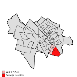
Lunetten is a neighbourhood[2] in the southeastern part of the city of Utrecht,[3] that has approximately 12.000 inhabitants. It is mainly a residential area, since there is no significant industry present. Lunetten was constructed as an urban experiment mostly during the late 1970s and 1980s. It was designed and planned by a combination of students of architecture and urban planning and the then foreseen future inhabitants.[citation needed] A result of this was the use of a ring-road with many circular bifurcations running back onto themselves or with dead ends. In Dutch this is called a Bloemkoolwijk ("Cauliflower-neighbourhood"). This urban setup results in the whole neighbourhood becoming like a single living street, much like a distinct village within a city.
A neighbourhood, or neighborhood, is a geographically localised community within a larger city, town, suburb or rural area. Neighbourhoods are often social communities with considerable face-to-face interaction among members. Researchers have not agreed on an exact definition, but the following may serve as a starting point: "Neighbourhood is generally defined spatially as a specific geographic area and functionally as a set of social networks. Neighbourhoods, then, are the spatial units in which face-to-face social interactions occur—the personal settings and situations where residents seek to realise common values, socialise youth, and maintain effective social control."
Utrecht is the fourth-largest city and a municipality of the Netherlands, capital and most populous city of the province of Utrecht. It is located in the eastern corner of the Randstad conurbation, and in the very centre of mainland Netherlands, and had a population of 345,080 in 2017.
A residential area is a land used in which housing predominates, as opposed to industrial and commercial areas. Housing may vary significantly between, and through, residential areas. These include single-family housing, multi-family residential, or mobile homes. Zoning for residential use may permit some services or work opportunities or may totally exclude business and industry. It may permit high density land use or only permit low density uses. Residential zoning usually includes a smaller FAR than business, commercial or industrial/manufacturing zoning. The area may be large or small.
Lunetten has a network of alleyways connecting the inner courtyards of the urban blocks. This creates a child-friendly neighbourhood with many playing spots. There are also many sports facilities within and around Lunetten.
Lunetten is surrounded by major railroads and highways. To cope with the noise and pollution a park was created to surround and insulate the neighbourhood.
Pollution is the introduction of contaminants into the natural environment that cause adverse change. Pollution can take the form of chemical substances or energy, such as noise, heat or light. Pollutants, the components of pollution, can be either foreign substances/energies or naturally occurring contaminants. Pollution is often classed as point source or nonpoint source pollution. In 2015, pollution killed 9 million people in the world.
Lunetten has the longest (140 meters) lightweight bridge in the world with a weight of 400 tonnes (Viaduct Nieuwe Houtenseweg).[4] This was constructed on the A27 on the weekend of 3 and 4 March 2012.
A geographic coordinate system is a coordinate system that enables every location on Earth to be specified by a set of numbers, letters or symbols. The coordinates are often chosen such that one of the numbers represents a vertical position and two or three of the numbers represent a horizontal position; alternatively, a geographic position may be expressed in a combined three-dimensional Cartesian vector. A common choice of coordinates is latitude, longitude and elevation. To specify a location on a plane requires a map projection.
Related Research Articles
South Holland is a province of the Netherlands with a population of just over 3.6 million as of 2015 and a population density of about 1,300/km2 (3,400/sq mi), making it the country's most populous province and one of the world's most densely populated areas. Situated on the North Sea in the west of the Netherlands, South Holland covers an area of 3,403 km2 (1,314 sq mi), of which 585 km2 (226 sq mi) is water. It borders North Holland to the north, Utrecht and Gelderland to the east, and North Brabant and Zeeland to the south. The provincial capital is The Hague, while its largest city is Rotterdam.
The Hague is a city on the western coast of the Netherlands and the capital of the province of South Holland. It is also the seat of government of the Netherlands.
Tilburg is a city in the Netherlands, in the southern province of North Brabant. With a population of 217,595, it is the second largest municipality in North Brabant, and the sixth largest in the Netherlands.
North Holland is a province of the Netherlands located in the northwestern part of the country. It is situated on the North Sea, north of South Holland and Utrecht, and west of Friesland and Flevoland. In 2015, it had a population of 2,762,163 and a total area of 2,670 km2 (1,030 sq mi).
Almere is a planned city and municipality in the province of Flevoland, Netherlands, bordering Lelystad and Zeewolde. The municipality of Almere comprises six official areas that are the districts of Almere Stad, Almere Buiten and Almere Pampus, and the boroughs of Almere Haven, Almere Hout and Almere Poort. Four of them feature official district or borough offices. Furthermore, it also comprises the unofficial historic district and neighborhood Oostvaardersdiep, which has an active semi-self-governing community, and the planned district of Almere Oosterwold. Almere is part of the Amsterdam Metropolitan Area (MRA).
Nijkerk is a municipality and a city located in the middle of the Netherlands, in the province of Gelderland.
IJsselstein is a municipality and a city in the Netherlands, in the province of Utrecht. IJsselstein received city rights in 1331. IJsselstein owes its name to the river Hollandse IJssel which flows through the city. It is a major commuting suburb for the Utrecht area, along with neighbouring towns Houten and Nieuwegein. It's surrounded by the municipalities of Utrecht, Montfoort, Lopik, Vianen and Nieuwegein.
Diemen is a town and municipality with a population of 27,734 in the province of North Holland, Netherlands. It is located approximately 6 kilometres southeast of Amsterdam's city centre, within the Amsterdam metropolitan area.
The Amsterdam Metro is a rapid transit system serving Amsterdam, Netherlands and extending to the surrounding municipalities of Diemen and Ouder-Amstel. The network is owned by the City of Amsterdam and operated by municipal public transport company Gemeentelijk Vervoerbedrijf (GVB) which also operates trams, free ferries and local buses. The metro system consists of five routes and serves 39 stations, with a total length of 42.7 kilometers (26.5 mi)
The Randstad is a megalopolis in the central-western Netherlands consisting primarily of the four largest Dutch cities and their surrounding areas. Among other things, it contains the Port of Rotterdam, and Amsterdam Airport Schiphol. With a population of 8.2 million people it is one of the largest metropolitan regions in Europe, comparable in population size to the Milan metropolitan area or the San Francisco Bay Area, and covers an area of approximately 8,287 km2 (3,200 sq mi). With a population density of 1,500/km2 it also is one of the most important and densely populated economic areas in northwestern Europe. It encompasses both the Amsterdam metropolitan area and Rotterdam–The Hague metropolitan area.
The Vondelpark is a public urban park of 47 hectares in Amsterdam, Netherlands. It is part of the borough of Amsterdam-Zuid and situated west from the Leidseplein and the Museumplein. The park was opened in 1865 and originally named Nieuwe Park, but later renamed to Vondelpark, after the 17th-century playwright and poet Joost van den Vondel. Yearly, the park has around 10 million visitors. In the park is an open-air theatre, a playground and several horeca facilities.
Marinus Dijkhuizen is a Dutch football manager, coach and former player, who is currently assistant manager of FC Utrecht. As a player, he had notable spells in his native Netherlands with Excelsior, SC Cambuur and TOP Oss. He retired in 2009 and entered management, eventually returning to S.B.V. Excelsior as manager in 2014.
Indische Buurt is a neighborhood in the borough of Oost, the eastern part of the city of Amsterdam, Netherlands. The name of the neighborhood dates from the early 20th century, and is derived from the fact that the neighborhood's streets are named after islands and other geographical concepts in the former Dutch colony of the Dutch East Indies or now known as Indonesia. The first street was named in 1902.
Amsterdam-Zuid is a borough (stadsdeel) of Amsterdam, Netherlands. The borough was formed in 2010 as a merger of the former boroughs Oud-Zuid and Zuideramstel. The borough has almost 138,000 inhabitants (2013). With 8,500 homes per square kilometer, it is one of the most densely populated boroughs of Amsterdam. It has the highest income per household of all boroughs in Amsterdam.
Amsterdam Nieuw-West is a borough comprising the westernmost neighbourhoods of the city of Amsterdam, Netherlands. It was created in 2010 after a merger of the former boroughs Osdorp, Geuzenveld-Slotermeer and Slotervaart. In 2017, the borough had almost 150,000 inhabitants.
Rivierenbuurt is a neighbourhood of Amsterdam, Netherlands. The neighbourhood is situated in the eastern part of the borough of Amsterdam-Zuid, bordered by the river Amstel to the east, the Boerenwetering canal in the west, the Amstelkanaal in the north and the A10 motorway in the south. In 2013, the Rivierenbuurt had approximately 28,400 residents.
FC Utrecht Vrouwen was the women's football section of Dutch club FC Utrecht based in Utrecht. Established in 2007, as one of the founding members of the professional Dutch women's football league the team competed in the league from its inaugural season (2007–08) until 2011–12 and the BeNe League from 2012–13 until the team's dissolution in January 2014. The club won the Dutch Cup once and the Dutch Super Cup once.
The Kadijken, also known as Kadijkseiland or Kadijkenbuurt, is a neighbourhood to the north of Artis zoo in the centre of Amsterdam. The name "Kadijken" is the plural form of Kadijk and refers to the two main streets that traverse the neighbourhood, Hoogte Kadijk and Laagte Kadijk.
Halte Amsterdam ArenA (Asdar) is a single rail train halt in the Bijlmermeer neighbourhood of stadsdeel (borough) Amsterdam-Zuidoost in Amsterdam, Netherlands. Situated right at the Johan Cruyff Arena, a football stadium which was previously known as the Amsterdam Arena, the station is specially built for supporter trains deployed during football matches that are considered high risk to the public, such as when local football club AFC Ajax face either Feyenoord, FC Utrecht, PSV or ADO Den Haag. In away matches supporters arrive and depart via this rail station. Regular attendants of the Ajax matches usually arrive via either the Duivendrecht railway station or the Amsterdam Bijlmer ArenA railway station. Many away supporters also commonly arrive at the stadium by bus as well.
This page is based on this Wikipedia article Text is available under the CC BY-SA 4.0 license; additional terms may apply. Images, videos and audio are available under their respective licenses.