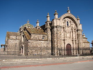
Lampa province is a province of the Puno region in Peru. Its population is about 40,856. The capital is Lampa.
Palca District is one of ten districts of the province Lampa in Peru.
Paratia District is one of ten districts of the province Lampa in Peru.
Pucará District is one of ten districts of the province Lampa in Peru.
Pukarani is a mountain with an archaeological site of the same name in the Andes of Peru, about 4,301.9 m (14,114 ft) high. It is located in the Puno Region, Lampa Province, Nicasio District.

Intikancha is a mountain with an archaeological site of the same name in the Andes of Peru, about 4,400 metres (14,436 ft) high. It is located in the Puno Region, Lampa Province, Nicasio District, and in the San Román Province, Juliaca District.
Hatun Pastu is a mountain in the Andes of Peru, about 5,170 metres (16,962 ft) high. It is located in the Puno Region, Lampa Province, on the border of the districts Palca and Paratía, southeast of the mountain Qillqa and north of Waykira.
Yanawara or Mina Punta is a mountain in the Andes of Peru, about 5,465 metres (17,930 ft) high. It is located in the Puno Region, Lampa Province, on the border of the districts Palca and Paratía. Yanawara lies northwest of the lake Sayt'uqucha.
Qillqa is a mountain in the Andes of Peru, about 5,350 metres (17,552 ft) high. It is located in the Puno Region, Lampa Province, on the border of the districts Palca and Paratía. Qillqa lies northwest of the mountains Yanawara, Waykira and Hatun Pastu.
Wisa Wisa is a mountain in the Andes of Peru, about 4,849.4 metres (15,910 ft) high. It is situated in the Puno Region, Lampa Province, Vilavila District, and in the Melgar Province, Ayaviri District. Wisa Wisa lies near the mountains Pukarani (Pucarani) in the northwest and Wallatani (Huallatane) in the southeast, southwest of a place called Wisa Wisa (Huisa Huisa).
Qullqi is a mountain in the Andes in southern Peru, about 4,916.1 metres (16,129 ft) high. It is situated in the Puno Region, Lampa Province, Pucará District.
Aqup'ukru is a 4,997-metre-high (16,394 ft) mountain in the Andes of Peru. It is located in the Puno Region, Lampa Province, Paratía District. Aqup'ukru is situated south of the mountain Yanawara, west of the lake Sayt'uqucha and southeast of the mountain Pachakutiq.
Waykira is a mountain in the Andes of Peru, about 5,200 metres (17,060 ft) high. It is located in the Puno Region, Lampa Province, on the border of the districts Palca and Paratía. Waykira lies southeast of the mountain Qillqa and south of Hatun Pastu.
Wira Apachita is a mountain in the Andes of Peru, about 5,100 metres (16,732 ft) high. It is located in the Puno Region, Lampa Province, Palca District. Wira Apachita is situated northeast of the lake Sayt'uqucha and the mountain Yanawara.
Yanawara is a mountain in the Andes of Peru, about 5,000 metres (16,404 ft) high. It is located in the Puno Region, Lampa Province, on the border of the districts Palca and Paratía. Yanawara is situated southeast of the higher mountain named Yanawara and the peaks of Wira Apachita and Yaritayuq, and northeast of the lake Sayt'uqucha.
Wankarani is a mountain in the Andes of Peru, about 4,800 metres (15,748 ft) high. It is located in the Puno Region, Lampa Province, Palca District.
Kuntur Puñuna is a mountain in the Andes of Peru, about 4,800 metres (15,748 ft) high. It is located in the Puno Region, Lampa Province, Santa Lucía District.
Pariwana is a 5,022-metre-high (16,476 ft) mountain in the Andes of Peru. It is located in the Puno Region, Lampa Province, on the border of the districts of Palca and Vilavila. Pariwana lies north of Qillqa.
Yaritayuq is a mountain in the Andes of Peru, about 4,800 m (15,700 ft) high. It is located in the Puno Region, Lampa Province, on the border of the districts of Palca and Paratia. Yaritayuq lies east of Yanawara.


