
Scouting in Oklahoma has a long history, from the 1910s to the present day, serving thousands of youth in programs that suit the environment in which they live.

Pomona is a city in eastern Los Angeles County, California, United States. Pomona is located in the Pomona Valley, between the Inland Empire and the San Gabriel Valley. At the 2020 census, the city's population was 151,713. The main campus of California State Polytechnic University, Pomona, also known as Cal Poly Pomona, lies partially within Pomona's city limits, with the rest being located in the neighboring unincorporated community of Ramona.
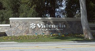
Valencia is a neighborhood in Santa Clarita located within Los Angeles County, California. It is one of the four unincorporated communities that merged to create the city of Santa Clarita in 1987. It is situated in the western part of Santa Clarita, stretching from Lyons Avenue to the south to north of Copper Hill Drive, and from Interstate 5 east to Bouquet Canyon and Seco Canyon Roads. Valencia was founded as a master-planned community with the first development, Old Orchard I, built on Lyons Avenue behind Old Orchard Elementary School.

The Santa Clarita Valley (SCV) is part of the upper watershed of the Santa Clara River in Southern California. The valley was part of the 48,612-acre (19,673 ha) Rancho San Francisco Mexican land grant. Located in Los Angeles County, its main population center is the city of Santa Clarita which includes the neighborhoods of Canyon Country, Newhall, Saugus, and Valencia. Adjacent unincorporated communities include Castaic, Stevenson Ranch, Val Verde, and Valencia.
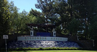
Stevenson Ranch is an unincorporated community in the Santa Clarita Valley of Los Angeles County, California. Stevenson Ranch is set in the foothills of the Santa Susana Mountains and lies west of Interstate 5 and the city of Santa Clarita. Stevenson Ranch encompasses about 6.4 square miles (17 km2). About 1,000 acres (4.0 km2) are set aside as parks, recreation areas, and open space. A master-planned community, it was approved by the county Board of Supervisors in 1985. The population was 20,178 at the time of the 2020 census. For statistical purposes, the Census Bureau has designated it a census-designated place (CDP).

Canyon Country is a neighborhood in the eastern part of the city of Santa Clarita, in northwestern Los Angeles County, California, United States. It lies along the Santa Clara River between the Sierra Pelona Mountains and the San Gabriel Mountains. It is the most populous of Santa Clarita's four neighborhoods.

Valencia, officially the City of Valencia, is a 1st class component city in the province of Bukidnon, Philippines. According to the 2020 census, it has a population of 216,546 people. The city is applying for a Highly Urbanized City (HUC).

Located in Los Angeles County, California's San Gabriel Valley, the Boy Scouts of America's San Gabriel Valley Council (#40) was one of five councils serving Los Angeles County. It was headquartered in Pasadena.
The William S. Hart Union High School District is a school district in the Santa Clarita Valley of Los Angeles County, California. It serves all of the valley's high school students and most of its junior high school students. As of 2022–23, the total number of enrolled students was 22,469. The district's superintendent is Mike Kuhlman. The district is named after William S. Hart, one of the first western film stars, who lived in Newhall and was a local benefactor. The region served by the Hart District is also served by the Sulphur Springs, Saugus, Castaic, and Newhall elementary school districts.
Santa Clarita is a city in northwestern Los Angeles County in the U.S. state of California. With a 2020 census population of 228,673, it is the third-most populous city in Los Angeles County, the 17th-most populous in California, and the 103rd-most populous city in the United States. It is located about 30 miles (48 km) northwest of downtown Los Angeles, and occupies 70.75 square miles (183.2 km2) of land in the Santa Clarita Valley, along the Santa Clara River. It is a classic example of a U.S. edge city, satellite city, or boomburb.

Schönbuch is an almost completely wooded area south west of Stuttgart and part of the Southern German Escarpment Landscape. In 1972 the centre zone of Schönbuch became the first nature park in Baden-Württemberg.

Simi Valley is a city in the valley of the same name in the southeast region of Ventura County, California, United States. Simi Valley is 40 miles (65 km) from Downtown Los Angeles, making it part of the Greater Los Angeles Area. The city borders Thousand Oaks, Moorpark, and the Chatsworth neighborhood of Los Angeles. As of the 2020 U.S. Census the population was 126,356, up from 124,243 in 2010. The city of Simi Valley is surrounded by the Santa Susana Mountains and the Simi Hills, west of the San Fernando Valley, and northeast of the Conejo Valley. It grew as a bedroom community for the cities in the Los Angeles area and the San Fernando Valley when a freeway was built over the Santa Susana Pass.
Germany is a country in Central and Western Europe that stretches from the Alps, across the North European Plain to the North Sea and the Baltic Sea. It is the second-most populous country in Europe after Russia, and is seventh-largest country by area in the continent. The area of Germany ranked 63rd and covers 357,600 km2 (138,070 sq mi), consisting of 349,250 km2 (134,846 sq mi) of land and 8,350 km2 (3,224 sq mi) of waters, smaller than Japan but larger than Republic of the Congo.
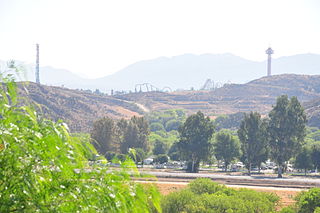
Valencia is an unincorporated community in northwestern Los Angeles County, California, United States. The area, west of Interstate 5, is expanding with residential development and already includes major commercial and industrial parks. It straddles State Route 126 and the Santa Clara River.
The Sawaga River is a river in Central Bukidnon, Philippines on the island of Mindanao. A majority of its catchment area is located in Malaybalay City. Its source is from a watershed west of Mt. Tuminungan in Barangay Dalwangan. It flows shortly northward and then eastward into Patpat and Kalasungay, the river then flows southward into the Poblacion District, past Casisang, San Jose, and Laguitas. The Lower Sawaga Valley is located in its lower course from Barangay Linabo through Bangcud until it meets with the Manupali River and ends at Pulangi River in Kahaponan, Valencia City. The Sawaga River has a total length of about 64.5 km and the basin has a total of 42,692 hectares.
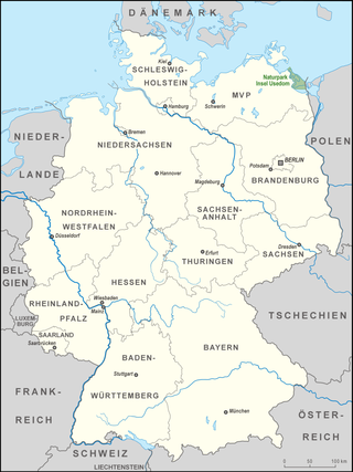
The Usedom Island Nature Park comprises the German part of the island of Usedom in the district of Vorpommern-Greifswald in the state of Mecklenburg-Vorpommern, Germany. In addition to the island itself, the park covers the waterbody between the island and the mainland as well as small strips of mainland in the northwest and west near the seaside resorts of Lubmin and the town of Lassan.
San Carlos is one of the 31 barangays of Valencia City, Bukidnon. It is bounded by Lurogan in the west, Bagontaas, Mailag, and Colonia in the east, Barobo in the south, and the Poblacion in the southeast.

Valencia Park is an urban community in the southeastern section of San Diego, California, United States. It is bordered by Emerald Hills and Market Street on the north, Lincoln Park and Euclid Avenue to the West, Encanto to the east, and Alta Vista and National City, California to the south. Major thoroughfares include Imperial Avenue, Churchward Street, and Valencia Parkway.

Skyline, also known as Skyline Hills or Skyline Park, is a hilly urban neighborhood in San Diego, California, located in Southeastern San Diego. It is bordered by Encanto to the west, Jamacha-Lomita to the North East, and Bay Terraces to the South. The neighborhood is split into two sections, Skyline West and Skyline East. The neighborhood is part of the Skyline-Paradise Hills Community Planning Area.

Bay Terraces is a hilly urban neighborhood in the southeastern part of San Diego, California, United States. A composite of North Bay Terrace and South Bay Terrace, it is bordered by Skyline to the north, Paradise Hills to the southwest, Alta Vista, South Encanto and National City to the west. The southern end of the neighborhood is bordered by State Route 54 and Bonita. The neighborhood generally includes the ZIP Codes 92114 and 92139 and as such, parts of the area have often been incorrectly referred to as either "Paradise Hills" or "Skyline Hills" due to its proximity and overlapping ZIP Codes. Nevertheless, Bay Terraces is the largest neighborhood in the Skyline-Paradise Hills Community Planning Area.