
The Santa Ana Mountains are a short peninsular mountain range along the coast of Southern California in the United States. They extend for approximately 61 miles (98 km) southeast of the Los Angeles Basin largely along the border between Orange and Riverside counties.
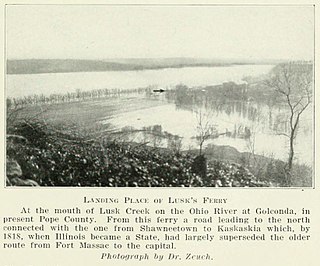
Lusk's Ferry was a place where pioneers crossed the Ohio River from Kentucky into Illinois. Some sources say that Golconda, Illinois was once called "Lusk's Ferry". Others say that the name properly refers to the place across the River, in Livingston County, Kentucky.

The Little Grand Canyon is a box canyon located in Shawnee National Forest in Jackson County, Illinois south of Murphysboro. It is located on east bank of the Big Muddy River across from Turkey Bayou to the west, between Swallow Rock to the north and Chalk Bluff to the south. Access to the park is gained from Hickory Ridge Road to the east. The area was designated a National Natural Landmark in February 1980.
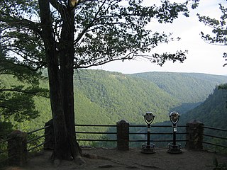
Colton Point State Park is a 368-acre (149 ha) Pennsylvania state park in Tioga County, Pennsylvania, in the United States. It is on the west side of the Pine Creek Gorge, also known as the Grand Canyon of Pennsylvania, which is 800 feet (240 m) deep and nearly 4,000 feet (1,200 m) across at this location. The park extends from the creek in the bottom of the gorge up to the rim and across part of the plateau to the west. Colton Point State Park is known for its views of the Pine Creek Gorge, and offers opportunities for picnicking, hiking, fishing and hunting, whitewater boating, and camping. Colton Point is surrounded by Tioga State Forest and its sister park, Leonard Harrison State Park, on the east rim. The park is on a state forest road in Shippen Township 5 miles (8 km) south of U.S. Route 6.
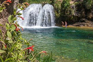
Fossil Creek is a perennial stream near the community of Strawberry in the U.S. state of Arizona. A tributary of the Verde River, Fossil Creek flows from its headwaters on the Mogollon Rim to meet the larger stream near the former Childs Power Plant.

Leonard Harrison State Park is a 585-acre (237 ha) Pennsylvania state park in Tioga County, Pennsylvania, in the United States. It is on the east rim of the Pine Creek Gorge, also known as the Grand Canyon of Pennsylvania, which is 800 feet (240 m) deep and nearly 4,000 feet (1,200 m) across here. It also serves as headquarters for the adjoining Colton Point State Park, its sister park on the west rim of the gorge. Leonard Harrison State Park is known for its views of the Pine Creek Gorge, and offers hiking, fishing and hunting, whitewater boating, and camping. The park is in Shippen and Delmar Townships, 10 miles (16 km) west of Wellsboro at the western terminus of Pennsylvania Route 660.
Keeley Creek Natural Area is a Research Natural Area and a National Natural Landmark that is protected by the United States Department of Agriculture, specifically through the branch of the Forest Service. It is located in Stony River Township, in Lake County, Minnesota, and is part of the Superior National Forest.

The West Rim Trail is a 30.5 mi (49.1 km) hiking trail along Pine Creek in Lycoming and Tioga Counties in north central Pennsylvania in the United States. The trail runs along Pine Creek Gorge, also known as the Grand Canyon of Pennsylvania, which is 800 feet (240 m) deep and about 2,000 feet (610 m) wide from rim to rim in the area traversed by the West Rim Trail. The trail is entirely within the Tioga State Forest and is known for its large number of vistas overlooking the gorge, which is a National Natural Landmark. The West Rim Trail was chosen by Outside Magazine as its "Best Hike in Pennsylvania" in April, 1996.

The Clear Springs Wilderness is a 4,730-acre (19.1 km²) parcel of land listed as a Wilderness Area of the United States. It contains the LaRue-Pine Hills Ecological Area, a National Natural Landmark noted for a large and diverse population of snakes.

The Panther Den Wilderness is a 1,195-acre (4.84 km2) parcel of land listed as a Wilderness Area of the United States. It is located within the Shawnee National Forest in Union County in the U.S. state of Illinois. Panther Den Wilderness is the smallest of eight Wilderness areas in Illinois. The other seven are Bald Knob Wilderness, Bay Creek Wilderness, Burden Falls Wilderness, Clear Springs Wilderness, Crab Orchard Wilderness, Garden of the Gods, and Lusk Creek Wilderness. All Illinois Wilderness areas are located in Southern Illinois.
The Bay Creek Wilderness is a 2,866-acre (11.60 km2) parcel of land listed as a Wilderness Area of the United States. It is located within the Shawnee National Forest in Pope County, Illinois. The nearest town of any size is Eddyville.

Buffalo Lake National Wildlife Refuge is a protected area in Randall County in the Texas Panhandle. Its shortgrass prairies spill into marshes, woodlands, riparian habitat, croplands, and water-carved canyon walls that together form 7,664 acres (31.02 km2) of homes for migratory and year-round wildlife. The area forms a habitat for black-tailed prairie dogs and burrowing owls, among many other species. Some 175 acres (0.71 km2) of the refuge carries the designation of National Natural Landmark.

Bell Smith Springs Recreation Area is a National Natural Landmark designated in 1980 and located in Shawnee National Forest within Pope County, on Country Road 350E, near Eddyville.
San Felipe Creek is a stream in Imperial and San Diego Counties of California. It arises in the Volcan Mountains of San Diego County 33°11′57″N116°37′35″W, and runs eastward, gathering the waters of most of the eastern slope of the mountains and desert of the county before it empties into the Salton Sea. It is probably the last remaining perennial natural desert stream in the Colorado Desert region. In 1974, the San Felipe Creek Area was designated as a National Natural Landmark by the National Park Service.

Barbours Creek Wilderness is a U.S. wilderness area in the Eastern Divide Ranger District of George Washington and Jefferson National Forests of western Virginia, United States. The wilderness area was established in 1988 and consists of 5,382 acres (2,178 ha) of forests in the Appalachian Mountains ranging in elevation from 1,700 to 3,800 feet.

The Matilija Wilderness is a 29,207-acre (11,820 ha) wilderness area in Ventura and Santa Barbara Counties, Southern California. It is managed by the U.S. Forest Service, being situated within the Ojai Ranger District of the Los Padres National Forest. It is located adjacent to the Dick Smith Wilderness to the northwest and the Sespe Wilderness to the northeast, although it is much smaller than either one. The Matilija Wilderness was established in 1992 in part to protect California condor habitat.


