
New Delhi is the capital of India and a part of the National Capital Territory of Delhi (NCT). New Delhi is the seat of all three branches of the government of India, hosting the Rashtrapati Bhavan, Parliament House, and the Supreme Court of India. New Delhi is a municipality within the NCT, administrated by the NDMC, which covers mostly Lutyens' Delhi and a few adjacent areas. The municipal area is part of a larger administrative district, the New Delhi district.

Sir Edwin Landseer Lutyens was an English architect known for imaginatively adapting traditional architectural styles to the requirements of his era. He designed many English country houses, war memorials and public buildings. In his biography, the writer Christopher Hussey wrote, "In his lifetime (Lutyens) was widely held to be our greatest architect since Wren if not, as many maintained, his superior". The architectural historian Gavin Stamp described him as "surely the greatest British architect of the twentieth century".

Janpath, is one of the main roads in New Delhi. It starts out as Radial Road 1 in Connaught Place, adjacent to Palika Bazaar, and runs north–south perpendicular to, and past Rajpath. Originally called Queen's Way, it was an important part of Lutyens' design of the Lutyens' Delhi, upon the inauguration of new capital of India in 1931. Janpath Market is one of the most famous markets for tourists in New Delhi. The market essentially is a long line of boutique stores selling products which are hard to find in the malls and multi-chain stores of the city. The long line of boutiques is for budget travellers and shoppers, buyers of handicrafts and garments, curio and numerous Indian-style fast-food places.

7, Lok Kalyan Marg, formerly 7, Race Course Road, is the official residence and principal workplace of the Prime Minister of India. Situated on Lok Kalyan Marg, New Delhi, the official name of the Prime Minister's residence complex is Panchavati. It is spread over 4.9 hectares of land, comprising five bungalows in Lutyens' Delhi, built in the 1980s, which are the Prime Minister's office, residency zone and security establishment, including one occupied by Special Protection Group (SPG) and another being a guest house. However, even though there are 5 bungalows, they are collectively called 7, Lok Kalyan Marg. It does not house the Prime Minister's Office but has a conference room for informal meetings.

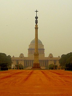
The Rashtrapati Bhavan is the official residence of the President of India at the western end of Rajpath in New Delhi, India. Rashtrapati Bhavan may refer to only the 340-room main building that has the president's official residence, including reception halls, guest rooms and offices, also called the mansion; it may also refer to the entire 130-hectare (320-acre) Presidential Estate that additionally includes the presidential gardens, large open spaces, residences of bodyguards and staff, stables, other offices and utilities within its perimeter walls. In terms of area, it is the largest residence of any head of state in the world.

Rajpath is a ceremonial boulevard in New Delhi, India, that runs from Rashtrapati Bhavan on Raisina Hill through Vijay Chowk and India Gate, National War Memorial to National Stadium, Delhi. The avenue is lined on both sides by huge lawns, canals and rows of trees. Considered to be one of the most important roads in India, it is where the annual Republic Day parade takes place on 26 January. Janpath crosses the road. Rajpath runs in east-west direction. Roads from Connaught Place, the financial centre of Delhi, run into Rajpath from north.
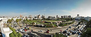
Connaught Place, officially known as Rajiv Chowk, is one of the main financial, commercial and business centres in New Delhi, Delhi, India. It houses the headquarters of several noted Indian firms and is a major shopping, nightlife and tourist destination in New Delhi. As of July 2018, Connaught Place was the ninth most expensive office location in the world with an annual rent of $1,650 per square metre ($153/sq ft).
Chanakyapuri is a neighbourhood and diplomatic enclave established in the 1950s in New Delhi. It is also a sub-division of the New Delhi district and plays host to the majority of foreign embassies in New Delhi. Chanakyapuri, meaning "city of Chanakya", is named after Chanakya, an ancient Indian philosopher, politician, military strategist and advisor to emperor Chandragupta Maurya.

Paharganj is a neighbourhood of Central Delhi, located just west of the New Delhi Railway Station. Known as Shahganj or King's ganj or market place during Mughal era, it is one of the three administrative subdivisions, of the Central Delhi district, of the National Capital Territory of Delhi, with the other two being, Darya Ganj and Karol Bagh.

The Parliament House in New Delhi is the seat of the Parliament of India. At a distance of 750 meters from the Rashtrapati Bhavan, it is located on Sansad Marg which crosses the Central Vista and is surrounded by the India Gate, war memorial, prime minister's office and residence, ministerial buildings and other administrative units of Indian government. Its houses the Lok Sabha and the Rajya Sabha which represent lower and upper houses respectively in India's bicameral parliament.

Lodhi Road in New Delhi, India, is named after the Lodhi Gardens located on it. Two Mughal mausoleums, Humayun's Tomb and Safdarjung's Tomb, lie at the eastern and western ends of the road respectively. A number of cultural, educational, and international institutions line the road. The Jor Bagh metro station lies under Aurobindo Marg near its intersection with Lodhi Road. Also located near it are Lodhi colony and Lodhi Estate built during British Raj in 1940s, and Lodhi Road Institutional Area.
Punjabi Bagh is a locality in Delhi, India. It also is one of the three sub-zones of West Delhi.
The Civil Lines is a residential area and one of the 3 subdivisions of the Central Delhi district of Delhi in India. It is one of the 12 zones under the Municipal Corporation of Delhi. It was the hub of European-style hotels in the city until New Delhi came into being in 1911. The official residence of the Lieutenant Governor of Delhi is also located at Raj Niwas Marg, Civil Lines.
Lutyens' Delhi is an area in Delhi, India, named after the British architect Sir Edwin Lutyens (1869–1944), who was responsible for much of the architectural design and building during the period of the British Raj, when India was part of the British Empire in the 1920s and 1930s and 1940s. This also includes the Lutyens Bungalow Zone (LBZ).

Coronation Park is a park located on Burari Road near Nirankari Sarovar in Delhi, India. The park is sometimes referred to as the Coronation Memorial; it was the venue of the Delhi Durbar of 1877 when Queen Victoria was proclaimed the Empress of India. Later it was used to celebrate the accession of King Edward VII in 1903, and, finally, it was here that the Durbar commemorating the coronation of King George V as Emperor of India took place on 12 December 1911, subsequent to his coronation at Westminster Abbey in June 1911. This last celebration had all the princely states in attendance. The decision to hold the Coronation Durbars in Delhi at the vast open ground at Coronation Park was a move to emphasise the historical significance of Delhi as the former capital of the Mughal Empire.
New Moti Bagh is a residential colony in South Delhi. New Moti Bagh occupies an area of 143 acres, in the exclusive New Delhi Municipal Council (NDMC) area of New Delhi. It is one of Delhi's most expensive areas, where land rates vary from 10 lakhs to 12 lakhs a square yard.

New Delhi railway station is the main railway station in Delhi, situated between Ajmeri Gate and Paharganj. It is one of the busiest railway stations in the country in terms of train frequency and passenger movement. Around 480 trains start, end, or pass through the station daily, which handled 500,000 passengers daily in 2013 with 16 platforms. The New Delhi railway station holds the record for the largest route interlocking system in the world along with the Kanpur Central railway station i.e. 48. The station is about two kilometres north of Connaught Place, in Central Delhi.
Jaisalmer House is the former residence of the Maharawal of Jaisalmer in New Delhi. It is part of Lutyens Bungalow Zone (LBZ).

Robert Tor Russell (1888–1972) was a British architect. In his position as Chief Architect to the Public Works Department of the Government of India, he is primarily associated with the development of the city of New Delhi in the early 1930s. He designed some of the city's most notable buildings and was the architect of Connaught Place, the financial centre of the new capital. Russell also served with distinction during the First World War, and later, after retiring from India, became a civil servant for the British Government.
Central Vista Redevelopment Project refers to the ongoing redevelopment to revamp the Central Vista, India's central administrative area located near Raisina Hill, New Delhi. The area was originally designed by Sir Edwin Lutyens and Sir Herbert Baker during British colonial rule and was retained by Government of India after independence.
