
Luxborough Street, formerly Northumberland Street, is a street in the City of Westminster, London, that runs from Marylebone Road in the north to Paddington Street in the south. Nottingham Street joins Luxborough Street on its eastern side.
Luxborough Street, formerly Northumberland Street, is a street in the City of Westminster, London, that runs from Marylebone Road in the north to Paddington Street in the south. Nottingham Street joins Luxborough Street on its eastern side.
Luxborough Street is mostly composed of small mansion blocks apart from on the western side which is the University of Westminster. [1]
Thomas de Quincey, later author of Confessions of an English Opium-Eater , lived at No. 5 in 1806–7. [2]
In 1835, the novelist Anthony Trollope lived in lodgings at No. 22. He was just starting his career with the General Post Office and complained that he never had the money to pay his rent. [3]
English novelist Rose Macauley, later author of The Towers of Trebizond , lived at No. 7-8 for most of the 1930s. [2]
The archaeologist and antiquarian Edward Pyddoke lived at No. 11 until his death in 1976. [4] [5]
The western side of Luxborough street was once the site of the St Marylebone Workhouse, later the St Marylebone Institution, and finally the Luxborough Lodge. It was closed in 1965 and demolished. The site became accommodation for the Polytechnic of Central London, later the University of Westminster. [6]

The City of Westminster is a London borough with city status in Greater London, England. It is the site of the United Kingdom's Houses of Parliament and much of the British government. It contains a large part of central London, including most of the West End, such as the major shopping areas around Oxford Street, Regent Street, Piccadilly and Bond Street, and the entertainment district of Soho. Many London landmarks are within the borough, including Buckingham Palace, Westminster Abbey, Whitehall, Westminster Cathedral, 10 Downing Street, and Trafalgar Square.

Anthony Trollope was an English novelist and civil servant of the Victorian era. Among his best-known works is a series of novels collectively known as the Chronicles of Barsetshire, which revolves around the imaginary county of Barsetshire. He also wrote novels on political, social, and gender issues, and other topical matters.

Fitzrovia is a district of central London, England, near the West End. The eastern part of the area is in the London Borough of Camden, and the western in the City of Westminster. It has its roots in the Manor of Tottenham Court, and was urbanised in the 18th century. Its name was coined in the late 1930s by Tom Driberg.

Long Acre is a street in the City of Westminster in central London. It runs from St Martin's Lane, at its western end, to Drury Lane in the east. The street was completed in the early 17th century and was once known for its coach-makers, and later for its car dealers.
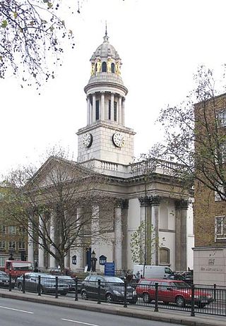
St Marylebone Parish Church is an Anglican church on the Marylebone Road in London. It was built to the designs of Thomas Hardwick in 1813–17. The present site is the third used by the parish for its church. The first was further south, near Oxford Street. The church there was demolished in 1400 and a new one erected further north. This was completely rebuilt in 1740–42, and converted into a chapel-of-ease when Hardwick's church was constructed. The Marylebone area takes its name from the church. Located behind the church is St Marylebone School, a Church of England school for girls.

Marylebone is an area in London, England and is located in the City of Westminster. It is in Central London and part of the West End. Oxford Street forms its southern boundary.

St Paul Covent Garden was a civil parish in the metropolitan area of London, England. The former area of the parish now corresponds to the Covent Garden market and surrounding streets in the City of Westminster.
Cleveland Street in central London runs north to south from Euston Road (A501) to the junction of Mortimer Street and Goodge Street. It lies within Fitzrovia, in the W1 post code area. Cleveland Street also runs along part of the border between Bloomsbury (ward) which is located in London Borough of Camden, and West End (ward) in the City of Westminster. In the 17th century, the way was known as the Green Lane, when the area was still rural, or Wrastling Lane, after a nearby amphitheatre for boxing and wrestling.

The Cleveland Street Workhouse is a Georgian property in Cleveland Street, Marylebone, built between 1775 and 1778 for the care of the sick and poor of the parish of St Paul Covent Garden under the Old Poor Law. From 1836, it became the workhouse of the Strand Union of parishes. The building remained in operation until 2005 after witnessing the complex evolution of the healthcare system in England. After functioning as a workhouse, the building became a workhouse infirmary before being acquired by the Middlesex Hospital and finally falling under the NHS. In the last century it was known as the Middlesex Hospital Annexe and the Outpatient Department. It closed to the public in 2005 and it has since been vacated. On 14 March 2011 the entire building became Grade II Listed. Development of the site began in 2019 by current owner University College London Hospitals (UCLH) Charity as a mixed-use development including residential, commercial and open space, but construction has been held up by the necessity to remove human remains stemming from the use of the area around the workhouse as a parish burial ground between 1780 and 1853. There has also been controversy about the amount of social housing to be included in the development.
Hinde Street is a street in the Marylebone district of the City of Westminster, London, that contains the Hinde Street Methodist Church and was home to the novelist Rose Macaulay until her death.

Great Cumberland Place is a street in the City of Westminster, part of Greater London, England. There is also a hotel bearing the same name on the street.

Paddington Street is a street in the City of Westminster in London that runs from the junction of Crawford Street and Baker Street in the east to Marylebone High Street in the west.

Beaumont Street is a street in the City of Westminster, London, that runs from Marylebone High Street in the north to the junction of Westmoreland Street and Weymouth Street in the south. The street is crossed midway by Devonshire Street and Clarkes Mews adjoins Beaumont Street on its eastern side at the southern end.

Westmoreland Street is in the Marylebone district of the City of Westminster in London, England. The street was built from the 1760s by William Franks and runs from Beaumont Street and Weymouth Street in the north to New Cavendish Street in the south. It was formerly the location of the Welbeck Chapel, which became St James's Church. In 1968, it was the site of Britain's first heart transplant when the National Heart Hospital was located there. The hospital is now known as University College Hospital at Westmoreland Street.

Nottingham Street is a street in the City of Westminster, London, that runs from Marylebone High Street in the east to Luxborough Street in the west. It is crossed by Nottingham Place. Bingham Place and Oldbury Place join it on the north side.

Poland Street is a street in the Soho district of the City of Westminster, London. It runs from Oxford Street in the north to Broadwick Street in the south. It was named after the "King of Poland" pub, which was renamed in honour of Poland's King John III Sobieski in the heading of a coalition of western armies, crucially defeated the invading Ottoman forces at the 1683 Battle of Vienna. In the eighteenth century, Polish Protestants settled around Poland Street as religious refugees fleeing the Polish Counterreformation.

Henrietta Place, originally known as Henrietta Street, is a street in Marylebone in the City of Westminster in central London that runs from Marylebone Lane in the east to Cavendish Square in the west. It is joined on the north side by Welbeck Street and Wimpole Street, and on the south side by Vere Street, Chapel Place, and Old Cavendish Street.

Wells Street is a street in the City of Westminster. It runs from Riding House Street in the north to Oxford Street in the south. It is crossed by Mortimer Street and Eastcastle Street. It is joined on its western side by Marylebone Passage and on the eastern side by Booth's Place and Wells Mews.
Edward Whately Pyddoke was a British archaeologist, antiquarian, and author on archaeological and related subjects, who served as Secretary and Registrar for the University of London Institute of Archaeology.

York Street is a street in Marylebone in Central London. Located in the City of Westminster, it runs west from Baker Street in a straight line until it begins curving when it becomes Harcourt Street towards the Old Marylebone Road. It crosses a number of streets including Seymour Place, Upper Montagu Street and Gloucester Place.
![]() Media related to Luxborough Street, London at Wikimedia Commons 51°31′18″N0°09′14″W / 51.5216°N 0.1540°W
Media related to Luxborough Street, London at Wikimedia Commons 51°31′18″N0°09′14″W / 51.5216°N 0.1540°W
| | This London road or road transport-related article is a stub. You can help Wikipedia by expanding it. |