
Carbon County is a county located in the U.S. state of Montana. As of the 2020 census, the population was 10,473. Its county seat is Red Lodge.
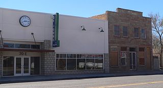
St. Johns is the county seat of Apache County, Arizona, United States. It is located along U.S. Route 180, mostly west of where that highway intersects with U.S. Route 191. As of the 2010 census, the population of the city was 3,480.

Gila Bend, founded in 1872, is a town in Maricopa County, Arizona, United States. The town is named for an approximately 90-degree bend in the Gila River, which is near the community's current location. As of the 2020 census, the population of the town was 1,892.

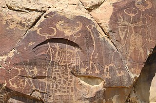
A petroglyph is an image created by removing part of a rock surface by incising, picking, carving, or abrading, as a form of rock art. Outside North America, scholars often use terms such as "carving", "engraving", or other descriptions of the technique to refer to such images. Petroglyphs, estimated to be 20,000 years old are classified as protected monuments and have been added to the tentative list of UNESCO's World Heritage Sites. Petroglyphs are found worldwide, and are often associated with prehistoric peoples. The word comes from the Greek prefix petro-, from πέτρα petra meaning "stone", and γλύφω glýphō meaning "carve", and was originally coined in French as pétroglyphe.

Standing Stone Creek is a 34.2-mile-long (55.0 km) tributary of the Juniata River in Huntingdon and Centre counties, Pennsylvania, in the United States.

Coso Rock Art District is a rock art site containing over 100,000 Petroglyphs by Paleo-Indians and/or Native Americans. The district is located near the towns of China Lake and Ridgecrest, California. Big and Little Petroglyph Canyons were declared a National Historic Landmark in 1964. In 2001, they were incorporated into this larger National Historic Landmark District. There are several other distinct canyons in the Coso Rock Art District besides the Big and Little Petroglyph Canyons. Also known as Little Petroglyph Canyon and Sand Tanks, Renegade Canyon is but one of several major canyons in the Coso Range, each hosting thousands of petroglyphs. The majority of the Coso Range images fall into one of six categories: bighorn sheep, entopic images, anthropomorphic or human-like figures, other animals, weapons & tools, and "medicine bag" images. Scholars have proposed a few potential interpretations of this rock art. The most prevalent of these interpretations is that they could have been used for rituals associated with hunting.
Legend Rock Petroglyph Site is located in Hot Springs County, Wyoming, 20 miles northwest of Hot Springs State Park. Legend Rock is a petroglyph site which features hundreds of individual petroglyphs spread across the face of the rock. Although a handful of the rock's etchings have variously been eroded and defaced, a wide majority have been preserved for public viewing. The nearly 300 individual petroglyphs feature some of the oldest and best examples of Dinwoody rock art in the world. The origins of the petroglyphs are still subject to debate. The site was listed on the National Register of Historic Places on July 5, 1973 and it is preserved by the state of Wyoming as a state historic site.

This is a list of the National Register of Historic Places listings in Pueblo County, Colorado, USA.

The Painted Rock Petroglyph Site is a collection of hundreds of ancient petroglyphs near the town of Theba, Arizona, United States, listed on the National Register of Historic Places in 1977. The site is operated and maintained by the Bureau of Land Management (BLM), and includes an improved campground as well as an informative walking trail showcasing the petroglyphs.

The Barnesville Petroglyph petroglyph site in the eastern part of the U.S. state of Ohio. Located approximately 3 miles (4.8 km) southwest of the village of Barnesville in Belmont County, the petroglyphs have been known both by archaeologists and the general public since the 1850s or earlier. Although the site was significantly damaged during the twentieth century, it is still a significant archaeological site, and has been named a historic site.

The Trail of the Ancients is a collection of National Scenic Byways located in the U.S. Four Corners states of Utah, Colorado, New Mexico, and Arizona. These byways comprise:
The Northern Avenue Petroglyph Site, in Kingman, Arizona, is a 0.2-acre (0.081 ha) archeological site that was listed on the U.S. National Register of Historic Places in 1996. It has also been known as "AZ F;12:22(ASM)". It served as a ceremonial site and an animal facility, in prehistory.

The Abert Lake Petroglyphs are a prehistoric archaeological site in Lake County, Oregon, United States. Peoples of the Great Basin cultural tradition pecked the images onto two basaltic boulders near major game migration routes. They are believed to be connected with rituals related to hunting activities, and contribute to the larger understanding of subsistence patterns in the northern Great Basin. They were made within the last 10,000 years, but their age cannot be stated more precisely due to the difficulty of dating petroglyphs.
Fertile is an unincorporated community in Washington County, in the U.S. state of Missouri.

The Newspaper Rock Petroglyphs Archeological District is part of the Petrified Forest National Park, and contains in excess of 650 petroglyphs, believed to have been created 1000–1500 CE. This Apache County site near Adamana, Arizona was listed on the National Register of Historic Places July 12, 1976.
Rattlesnake Point Pueblo is a single-story masonry pueblo ruin dating from the 14th and 15th centuries A.D. It is located in Lyman Lake State Park in between St. Johns and Springerville.

The Bluff Historic District, in Bluff, Utah, is a 225 acres (91 ha) historic district which was listed on the National Register of Historic Places in 1995. The district included 11 contributing buildings and six contributing sites.

