Montgomery County is a county in the U.S. state of Texas. As of the 2020 U.S. census, the county had a population of 620,443. The county seat is Conroe. The county was created by an act of the Congress of the Republic of Texas on December 14, 1837, and is named for the town of Montgomery. Between 2000 and 2010, its population grew by 55%, the 24th-fastest rate of growth of any county in the United States. Between 2010 and 2020, its population grew by 36%. According to the U.S. Census Bureau, the estimated population is 711,354 as of July 1, 2023.

Harris County is a county located in the U.S. state of Texas; as of the 2020 census, the population was 4,731,145, making it the most populous county in Texas and the third-most populous county in the United States. Its county seat is Houston, the most populous city in Texas and fourth-most populous city in the United States. The county was founded in 1836 and organized in 1837. It is named for John Richardson Harris, who founded the town of Harrisburg on Buffalo Bayou in 1826. According to the July 2022 census estimate, Harris County's population has shifted to 4,780,913 comprising over 16% of Texas's population. Harris County is included in the nine-county Houston–The Woodlands–Sugar Land metropolitan statistical area, which is the fifth-most populous metropolitan area in the United States.

Pasadena is a city in the U.S. state of Texas, located in Harris County. It is part of the Houston–The Woodlands–Sugar Land metropolitan area. As of the 2020 U.S. census, the city's population was 151,950, making it the twentieth most populous city in Texas and the second most populous in Harris County. The area was founded in 1893 by John H. Burnett of Galveston, who named the area after Pasadena, California, because of the perceived lush vegetation.

Baytown is a city in the U.S. state of Texas, within Harris and Chambers counties. Located in the Houston–The Woodlands–Sugar Land metropolitan statistical area, it lies on the northern side of the Galveston Bay complex near the outlets of the San Jacinto River and Buffalo Bayou. It is the sixth-largest city within this metropolitan area and seventh largest community. Major highways serving the city include State Highway 99, State Highway 146 and Interstate 10. At the 2020 U.S. census, Baytown had a population of 83,701, and it had an estimated population of 84,324 in 2022.

Galveston Bay is a bay in the western Gulf of Mexico along the upper coast of Texas. It is the seventh-largest estuary in the United States, and the largest of seven major estuaries along the Texas Gulf Coast. It is connected to the Gulf of Mexico and is surrounded by sub-tropical marshes and prairies on the mainland. The water in the bay is a complex mixture of sea water and fresh water, which supports a wide variety of marine life. With a maximum depth of about 10 feet (3 m) and an average depth of only 6 feet (2 m), it is unusually shallow for its size.
The Hardy Toll Road is a controlled-access toll road in the Greater Houston area of the U.S. state of Texas, maintained by the Harris County Toll Road Authority. The route runs from Interstate 610 near central Houston to Interstate 45 just south of the Harris–Montgomery county line. The road generally parallels Interstate 45. The portion from I-610 to Crosstimbers Road was designated on September 26, 1984 as Spur 548, although this is unsigned.

Buffalo Bayou is a slow-moving body of water which flows through Houston in Harris County, Texas. Formed 18,000 years ago, it has its source in the prairie surrounding Katy, Fort Bend County, and flows approximately 53 miles (85 km) east through the Houston Ship Channel into Galveston Bay and the Gulf of Mexico. In addition to drainage water impounded and released by the Addicks and Barker reservoirs, the bayou is fed by natural springs, surface runoff, and several significant tributary bayous, including White Oak Bayou, Greens Bayou, and Brays Bayou. Additionally, Buffalo Bayou is considered a tidal river downstream of a point 440 yards (400 m) west of the Shepherd Drive bridge in west-central Houston.
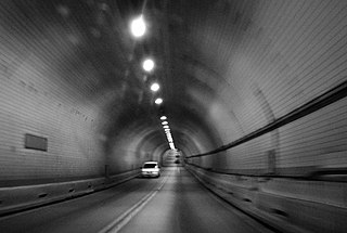
The Washburn Tunnel is a two-lane underwater motor-vehicle tunnel connecting Galena Park and Pasadena, two suburbs of Houston, Texas. Completed in 1950, it travels north-south underneath the Houston Ship Channel. It was named after Harris County, Texas Auditor Harry L. Washburn. It is the largest and first toll-free vehicular tunnel in the Southern United States.

Beltway 8 (BW8), the Sam Houston Parkway, along with the Sam Houston Tollway, is an 88-mile (142 km) beltway around the city of Houston, Texas, United States, lying entirely within Harris County.

State Highway 249, also known depending on its location as West Mount Houston Road, the Tomball Parkway, Tomball Tollway, MCTRA 249 Tollway, or the Aggie Expressway, is a 49.443-mile (79.571 km) generally north–south highway in Southeast Texas. The southern terminus is in North Houston at Interstate 45 (I-45). The current northern terminus of the highway is east of Navasota at SH 105.

The Westpark Tollway, also Fort Bend Westpark Tollway, is a controlled-access toll road in Texas, serving western Houston and Harris County, and northeastern Fort Bend County. Construction on the facility began in 2001 and portions of the road were opened to traffic in May 2004. Construction of the roadway was completed in August 2005. The Westpark Tollway begins on Westpark Drive just past the South Rice Avenue intersection in the Uptown District of Houston and runs approximately 22 miles (35 km) west to Farm to Market Road 1093 just past Farm to Market Road 723 in Fulshear, Texas. It runs roughly parallel and to the south of Westheimer Road in Harris County and concurrently with FM 1093 in Fort Bend County.

The Houston Ship Channel, in Houston, Texas, is part of the Port of Houston, one of the busiest seaports in the world. The channel is the conduit for ocean-going vessels between Houston-area terminals and the Gulf of Mexico, and it serves an increasing volume of inland barge traffic.
The North Texas Tollway Authority (NTTA) is a not-for-profit government organization that maintains and operates toll roads, bridges, and tunnels in the North Texas area. Functioning as a political subdivision of the State of Texas under Chapter 366 of the Transportation Code, the NTTA is empowered to acquire, construct, maintain, repair and operate turnpike projects; to raise capital for construction projects through the issuance of turnpike revenue bonds; and to collect tolls to operate, maintain and pay debt service on those projects.
The Fort Bend County Toll Road Authority (FBCTRA), also called the Fort Bend Grand Parkway Toll Road Authority (FBGPTRA), operates three toll roads in Fort Bend County and is headquartered at 1 Fluor Daniel Dr in Sugar Land in the U.S. state of Texas.
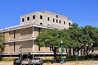
The Harris County Toll Road Authority maintains and operates a 103-mile (165.8 km) toll road system in the Greater Houston area of Texas, United States. Its headquarters are located in Houston's Fairbanks/Northwest Crossing neighborhood.

Sam Houston Tollway Ship Channel Bridge is a span in Harris County, Texas. It was acquired from the then–Texas Turnpike Authority (TTA) on May 5, 1994, and is now a part of the Harris County Toll Road Authority system. The bridge opened to traffic in May 1982 and carries four lanes of the Sam Houston Tollway over the Houston Ship Channel with a clearance of 175 feet (53 m).
Harris County Public Library (HCPL) is a public library system serving Harris County, Texas, United States.

The Texas Department of Transportation (TxDOT) is a governmental agency and its purpose is to "provide safe, effective, and efficient movement of people and goods" throughout the state. Though the public face of the agency is generally associated with maintenance of the state's immense highway system, the agency is also responsible for aviation in the state and overseeing public transportation systems.
There are approximately 25 current toll roads in the state of Texas. Toll roads are more common in Texas than in many other U.S. states, since the relatively low revenues from the state's gasoline tax limits highway planners' means to fund the construction and operation of highways.

Lynchburg is an unincorporated community in east central Harris County, Texas, United States.

