
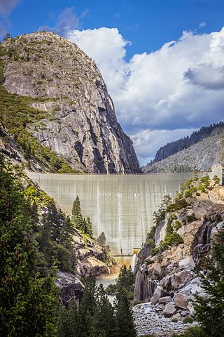
New Melones Dam is an earth and rock filled embankment dam on the Stanislaus River, about 5 miles (8.0 km) west of Jamestown, California, United States, on the border of Calaveras County and Tuolumne County. The water impounded by the 625-foot-tall (191 m) dam forms New Melones Lake, California's fourth-largest reservoir, in the foothills of the Sierra Nevada east of the San Joaquin Valley. The dam serves mainly for irrigation water supply, and also provides hydropower generation, flood control, and recreation benefits.

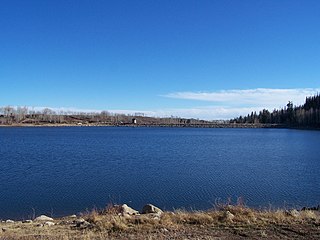
Merrill Creek Reservoir, located in Harmony Township, New Jersey in central Warren County, New Jersey, is a 650-acre (260 ha) artificial lake designed to hold 15 billion gallons of water that is surrounded by 290 acres (120 ha) of protected woodland and fields. These lands are themselves part of 2,000 acres (8.1 km2) of open spaces.

The Stanislaus River is a tributary of the San Joaquin River in north-central California in the United States. The main stem of the river is 96 miles (154 km) long, and measured to its furthest headwaters it is about 150 miles (240 km) long. Originating as three forks in the high Sierra Nevada, the river flows generally southwest through the agricultural San Joaquin Valley to join the San Joaquin south of Manteca, draining parts of five California counties. The Stanislaus is known for its swift rapids and scenic canyons in the upper reaches, and is heavily used for irrigation, hydroelectricity and domestic water supply.

Lake McCloud is a reservoir on the McCloud River in Northern California. The lake forms behind an earthen dam finished in 1965 by the Pacific Gas and Electric Company to control water flows and for generating hydro-electric power. McCloud Dam is 235 feet (72 m) high, 630 feet (190 m) long at its crest, and impounds a maximum capacity of 35,200 acre-feet (43,400,000 m3).
Lake Spaulding Dam is a dam in Nevada County, California.
Wishon Dam is a dam in Fresno County, California in the Sierra National Forest, in the Sierra Nevada Mountain Range. It impounds the North Fork Kings River to form Wishon Reservoir.
Iron Canyon Dam is a dam in Shasta County, California, United States.
Kolob Creek Dam is a dam in Washington County, Utah.

The Mahoning Creek Dam is a dam in Armstrong County, Pennsylvania.

Beardsley Dam is a dam on the Middle Fork Stanislaus River in Tuolumne County, California. The site is surrounded by the Stanislaus National Forest.
Silver Jack Dam is a dam in Gunnison County, Colorado.

North Hartland Dam is a dam on the Ottauquechee River in Hartland, Windsor County, Vermont.

Bear River Dam is a dam in Amador County, California, due east of Sacramento.
Strawberry Dam, also known as Main Strawberry Dam, is a dam in Tuolumne County, California.
Donnells Dam is a concrete arch dam located on the Middle Fork of the Stanislaus River in Tuolumne County, California. The water impounded by the 291-foot (89 m) high dam forms Donnell Lake in Stanislaus National Forest. The dam and reservoir are co-owned by the Oakdale Irrigation District and South San Joaquin Irrigation District, and the dam is one of three in the Tri-Dam Project. The other two dams in the project are Beardsley Dam and Tulloch Dam.
Slab Creek Dam is a dam in the American River watershed of the central Sierra Nevada, within El Dorado County, California.

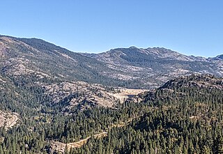
The Middle Fork Stanislaus River is a 45.7-mile (73.5 km) tributary of the Stanislaus River in the central Sierra Nevada and Stanislaus National Forest of eastern California.
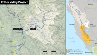
The Potter Valley Project is an interbasin water transfer project in Northern California in the United States, delivering water from the Eel River basin to turbines in the headwaters of the Russian River. The project is owned and operated by Pacific Gas and Electric Company (PG&E). The main facilities are two dams on the Eel River, a diversion tunnel and hydroelectric plant. Average annual throughput is 159,000 acre⋅ft (196,000,000 m3), although this figure varies significantly with both the amount of precipitation in the Eel River basin and the demand on the Russian River.

The Upper North Fork Feather River Project is a hydroelectric scheme in the Sierra Nevada of California, within Lassen and Plumas Counties. The project consists of three dams, five power plants, and multiple conduits and tunnels in the headwaters of the North Fork Feather River, a major tributary of the Feather—Sacramento River systems. The total installed capacity is 362.3 megawatts (MW), producing an annual average of 1,171.9 gigawatt hours (GWh). The project is also contracted for the delivery of irrigation water between March 31 and October 31 of each year. The project is owned and operated by Pacific Gas and Electric Company.

Relief Dam is a rockfill dam on Summit Creek, a tributary of the Middle Fork Stanislaus River, in Tuolumne County, California. The dam is part of the Spring Gap-Stanislaus Hydroelectric Project, and is owned and operated by Pacific Gas and Electric (PG&E).
