South Fork Stanislaus River

Last updated
South Fork Stanislaus River
Country United States
State California
Source Sierra Nevada
 - location Stanislaus National Forest
 - elevation 8,642 ft (2,634 m)
 - coordinates 38°13′29″N119°49′05″W / 38.22472°N 119.81806°W / 38.22472; -119.81806   [1]
Mouth Stanislaus River
 - location New Melones Lake
 - elevation 1,050 ft (320 m)
 - coordinates 38°04′26″N120°25′24″W / 38.07389°N 120.42333°W / 38.07389; -120.42333 Coordinates: 38°04′26″N120°25′24″W / 38.07389°N 120.42333°W / 38.07389; -120.42333   [1]
Length 48.5 mi (78 km) [2]
Discharge for near Long Barn
 - average 85.1 cu ft/s (2 m3/s) [3]
 - max 12,900 cu ft/s (365 m3/s)
 - min 0 cu ft/s (0 m3/s)
Stanislausmap1.png
Map of the Stanislaus River watershed, showing the South Fork

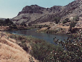
The South Fork Stanislaus River is a major tributary of the Stanislaus River in Tuolumne County, California. The river flows for 48.5 miles (78.1 km) [2] through rugged alpine and foothill areas of the Sierra Nevada.

Stanislaus River river in the United States of America

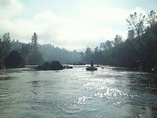
The Stanislaus River is a tributary of the San Joaquin River in north-central California in the United States. The main stem of the river is 96 miles (154 km) long, and measured to its furthest headwaters it is about 150 miles (240 km) long. Originating as three forks in the high Sierra Nevada, the river flows generally southwest through the agricultural San Joaquin Valley to join the San Joaquin south of Manteca, draining parts of five California counties. The Stanislaus is known for its swift rapids and scenic canyons in the upper reaches, and is heavily used for irrigation, hydroelectricity and domestic water supply.

Tuolumne County, California County in California, United States

Tuolumne County, officially the County of Tuolumne, is a county in the U.S. state of California. As of the 2010 census, the population was 54,179. The county seat and only incorporated city is Sonora.

Sierra Nevada (U.S.) mountain range

The Sierra Nevada is a mountain range in the Western United States, between the Central Valley of California and the Great Basin. The vast majority of the range lies in the state of California, although the Carson Range spur lies primarily in Nevada. The Sierra Nevada is part of the American Cordillera, a chain of mountain ranges that consists of an almost continuous sequence of such ranges that form the western "backbone" of North America, Central America, South America and Antarctica.

The river begins in Hay Meadow in the Emigrant Wilderness of the Stanislaus National Forest. It flows generally southwest, past Pinecrest, Cold Springs and Long Barn, then descends west through a canyon to the New Melones Lake reservoir where it meets the Stanislaus River. [4]

Emigrant Wilderness

The Emigrant Wilderness of Stanislaus National Forest is a wilderness area in the Sierra Nevada. It is bordered by Yosemite National Park on the south, the Toiyabe National Forest and the Hoover Wilderness on the east, and State Route 108 over Sonora Pass on the north. It is an elongated area that extends northeast about 25 miles (40 km) in length and up to 15 miles (24 km) in width. Watersheds drain to the Stanislaus and Tuolumne Rivers. This area is entirely within Tuolumne County, California and is approximately 140 miles (230 km) east of San Francisco, California and 50 miles (80 km) south of Lake Tahoe.

Stanislaus National Forest designated in 1976

Stanislaus National Forest is a United States national forest which manages 898,099 acres of land in four counties in the Sierra Nevada in Northern California. It was established on February 22, 1897, making it one of the oldest national forests. It was named after the Stanislaus River.

Pinecrest, Tuolumne County, California Unincorporated community in California, United States

Pinecrest is an unincorporated community in Tuolumne County, California, United States. Pinecrest is located near Pinecrest Lake northwest of Mi-Wuk Village. Pinecrest Lake sits in what was once a meadow surrounded by granite outcroppings. Originally, Pinecrest Lake was called Strawberry Flat because of the wild strawberries that once grew there. In the 1960s the name was officially changed to Pinecrest. The campground adjacent to the lake is under the white fir, cedar, and sugar pine trees.

There are two dams on the South Fork: Strawberry Dam, which forms Pinecrest Lake, and Lyons Dam, impounding Lyons Reservoir, which provides municipal water supply to the Twain Harte area. Strawberry Dam is part of the Spring-Gap Stanislaus Hydroelectric Project, which uses water from the South Fork and Middle Forks of the Stanislaus River to generate power. [5]

Strawberry Dam, also known as Main Strawberry Dam, is a dam in Tuolumne County, California.

Lyons Dam is a dam in Tuolumne County, California.

Twain Harte, California census-designated place in California, United States

Twain Harte is a census-designated place (CDP) in Tuolumne County, California, United States. The population was 2,226 at the 2010 census, down from 2,586 at the 2000 census. Its name is derived from the last names of two famous authors who lived in California, Mark Twain and Bret Harte.

See also

Related Research Articles

Blue River (Colorado) tributary of the Colorado River in Colorado, USA

The Blue River is a tributary of the Colorado River, approximately 65 miles (105 km) long, in the U.S. state of Colorado.

Wind River (Wyoming) river in Wyoming

The Wind River is the name applied to the upper reaches of the Bighorn River in Wyoming in the United States. The Wind River is 185 miles (298 km) long. The two rivers are sometimes referred to as the Wind/Bighorn.

Clavey River river in the United States of America

The Clavey River is a tributary of the Tuolumne River in the Sierra Nevada, located in the Stanislaus National Forest and Tuolumne County, California. The river is 31.3 miles (50.4 km) long, and is one of the few undammed rivers on the western slope of the Sierra. Via the Tuolumne River, the Clavey is part of the San Joaquin River watershed.

Neosho River river in the United States of America

The Neosho River is a tributary of the Arkansas River in eastern Kansas and northeastern Oklahoma in the United States. Its tributaries also drain portions of Missouri and Arkansas. The river is about 463 miles (745 km) long. Via the Arkansas, it is part of the Mississippi River watershed. Its name is an Osage word meaning "clear water."

San Jacinto River (California)

The San Jacinto River is a 42-mile-long (68 km) river in Riverside County, California. The river's headwaters are in San Bernardino National Forest, but the lower portion of the 765-square-mile (1,980 km2) watershed is urban and agricultural land. As a partially endorheic watershed that is contiguous with other Great Basin watersheds, the western side of the San Jacinto Basin is a portion of the Great Basin Divide.

Cherry Creek (Tuolumne River tributary)

Cherry Creek is a large, swift-flowing stream in the Sierra Nevada mountain range, and is the largest tributary of the Tuolumne River. The creek is 40 miles (64 km) long measured to its farthest headwaters; the main stem itself is 26 miles (42 km) long, draining a watershed of 234 square miles (610 km2) in the Stanislaus National Forest. Part of the drainage also extends into the northwest corner of Yosemite National Park.

South Fork American River river in the United States of America

The South Fork American River is a major tributary of the American River in El Dorado County, California, draining a watershed on the western slope of the Sierra Nevada east of Sacramento. The river begins in pristine Desolation Wilderness and flows through the Sierra Nevada foothills. The river at Coloma was the site of James Marshall's discovery of gold at Sutter's Mill on January 24, 1848, which started the California Gold Rush. The South Fork of the American is "the most popular recreation stream in the West" for whitewater rafting in North America, e.g., 80,000 visitors in 2011.

Middle Fork Eel River river in the United States of America

The Middle Fork Eel River is a major tributary of the Eel River of northwestern California in the United States. It drains a rugged and sparsely populated region of the Yolla Bolly Mountains, part of the California Coast Range, in Trinity and Mendocino Counties. Its watershed comprises roughly 745 square miles (1,930 km2) of land, or 20% of the entire Eel River basin. The river provides groundwater recharge and is used for recreation and for industrial, agricultural and municipal water supply by residents.

Jemez River river in the United States of America

The Jemez River is a tributary of the Rio Grande in the U.S. state of New Mexico. The river is formed by the confluence of the East Fork Jemez River and San Antonio Creek, which drain a number of tributaries in the area of the Jemez Mountains and Santa Fe National Forest. The Jemez River is about 50 miles (80 km) long, or about 80 miles (130 km) long if its longest headwater tributary, San Antonio Creek, is included. The East Fork Jemez River is about 22 miles (35 km) long. Both San Antonio Creek and the East Fork Jemez River flow through intricate meanders along their courses. The East Fork Jemez is a National Wild and Scenic River.

Big Lost River river in the United States of America

The Big Lost River is a major river in the U.S. state of Idaho, about 135 miles (217 km) long. It starts in the Rocky Mountains and flows in a generally southeast direction into the Snake River Plain. True to its name, the Big Lost River's surface flow does not reach any larger river, but vanishes into the Snake River Aquifer at the Big Lost River Sinks, giving the river its name. The river is one of the Lost streams of Idaho, several streams that flow into the plain and disappear into the ground.

North Fork Kings River river in the United States of America

The North Fork Kings River is a 40.3-mile (64.9 km) tributary of the Kings River, in the U.S. state of California. The river's main stem is entirely within Fresno County, and its watershed drains about 387 square miles (1,000 km2) of the southern Sierra Nevada mountain range.

Spanish Fork River river in the United States of America

The Spanish Fork River or Spanish Fork is a river in the U.S. state of Utah. Formed by the confluence of Soldier Creek and Thistle Creek in the Wasatch Range, the river flows about 20 miles (32 km) northwest into Utah Lake, passing the towns of Spanish Fork and Palmyra.

Middle Fork Clearwater River river in the United States of America

The Middle Fork Clearwater River is a short, but high volume river in northern Idaho and is the major source of the Clearwater River, a tributary of the Snake River. The Middle Fork flows west for 23 miles (37 km) from the confluence of the Selway River and Lochsa River at Lowell, to the town of Kooskia where it joins with the South Fork Clearwater River to create the Clearwater River. The Middle Fork's entire length is within Idaho County, although a small portion of its watershed extends into Clearwater County.

North Fork Stanislaus River river in eastern California, USA

The North Fork Stanislaus River is a 31.2-mile (50.2 km) tributary of the Stanislaus River in the central Sierra Nevada and Stanislaus National Forest of eastern California.

Middle Fork Stanislaus River river in the United States of America

The Middle Fork Stanislaus River is a 45.7-mile (73.5 km) tributary of the Stanislaus River in the central Sierra Nevada and Stanislaus National Forest of eastern California.

Huasna River river in the United States of America

The Huasna River is a stream in the Central Coast region of California, and is a tributary of the Cuyama River. It is formed by the confluence of Trout Creek and Stony Creek, which originate along the crest of the Santa Lucia Range in the Los Padres National Forest. It flows south, past the community of Huasna and the Huasna Valley before reaching Twitchell Reservoir, which is created by a dam along the Cuyama River.

Indian Creek (Plumas County, California) stream in Plumas County, California, USA; tributary of the Feather River near Spanish Creek

Indian Creek is a major stream in the northern Sierra Nevada of Plumas County, California and is part of the Feather River system. The creek is 47 miles (76 km) long, flowing through a series of small towns and farming valleys in a rural, mountainous area.

North Fork Tuolumne River

The North Fork Tuolumne River is a 35.7-mile (57.5 km) long river in the central Sierra Nevada of Tuolumne County, California and is a major tributary of the Tuolumne River. It originates above the Dodge Ridge Ski Area about 2 miles (3.2 km) east of Pinecrest, in the Stanislaus National Forest. From there it flows generally southwest, past Long Barn, Twaine Harte, Soulsbyville and Tuolumne. Below Long Barn the river flows through a narrow canyon on its way to join the Tuolumne River, at the head of Lake Don Pedro Reservoir, about 5 miles (8.0 km) north of Groveland.

South Fork San Joaquin River

The South Fork San Joaquin River is the largest headwater of the San Joaquin River in central California, United States. About 48 miles (77 km) long, it drains an area of the high Sierra Nevada about 60 miles (97 km) northeast of Fresno.

References

  1. 1 2 "South Fork Stanislaus River". Geographic Names Information System . United States Geological Survey. 1981-01-19. Retrieved 2016-12-07.
  2. 1 2 "National Hydrography Dataset via National Map Viewer". U.S. Geological Survey. Retrieved 2017-10-02.
  3. "USGS Gage #11298000 on the South Fork Stanislaus River near Long Barn, CA" (PDF). National Water Information System. U.S. Geological Survey. 1937–2013. Retrieved 2016-12-07.
  4. USGS Topo Maps for United States (Map). Cartography by United States Geological Survey. ACME Mapper. Retrieved 2016-12-07.
  5. "Stanislaus-Spring Gap : P-2130". Hydropower Reform Coalition. Retrieved 2016-12-07.