
Aldhelm, Abbot of Malmesbury Abbey, Bishop of Sherborne, and a writer and scholar of Latin poetry, was born before the middle of the 7th century. He is said to have been the son of Kenten, who was of the royal house of Wessex. He was certainly not, as his early biographer Faritius asserts, the brother of King Ine. After his death he was venerated as a saint, his feast day being the day of his death, 25 May.

Lytchett Minster is a village in Dorset, England. It lies around 4 miles (6.4 km) north-west of Poole town centre. The village forms part of the civil parish of Lytchett Minster and Upton, Upton now being a suburb of Poole.

The Isle of Purbeck is a peninsula in Dorset, England. It is bordered by water on three sides: the English Channel to the south and east, where steep cliffs fall to the sea; and by the marshy lands of the River Frome and Poole Harbour to the north. Its western boundary is less well defined, with some medieval sources placing it at Flower's Barrow above Worbarrow Bay. John Hutchins, author of The History and Antiquities of the County of Dorset, defined Purbeck's western boundary as the Luckford Lake stream, which runs south from the Frome. According to writer and broadcaster Ralph Wightman, Purbeck "is only an island if you accept the barren heaths between Arish Mell and Wareham as cutting off this corner of Dorset as effectively as the sea." The most southerly point is St Alban's Head.

Purbeck was a local government district in Dorset, England. The district was named after the Isle of Purbeck, a peninsula that forms a large proportion of the district's area. However, it extended significantly further north and west than the traditional boundary of the Isle of Purbeck which is the River Frome. The district council was based in the town of Wareham, which is itself north of the Frome.

Lytchett Matravers is a large village and civil parish in Dorset, England. The 2011 census recorded the parish as having 1,439 households and a population of 3,424.

Worth Matravers is a village and civil parish in the English county of Dorset. The village is situated on the cliffs west of Swanage. It comprises limestone cottages and farm houses and is built around a pond, which is a regular feature on postcards of the Isle of Purbeck.

Upton is a town in south-east Dorset, England. Upton is to the east of Holton Heath and Upton Heath, and to the north of the Poole suburb of Hamworthy. It is the second largest town in the Purbeck Hills.
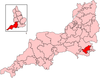
Mid Dorset and North Poole is a constituency represented in the House of Commons of the UK Parliament since 2024 by Vikki Slade, a Liberal Democrat.
The South East Dorset conurbation is a multi-centred conurbation on the south coast of Dorset in England.
Cogdean Hundred was a hundred in the county of Dorset, England, containing the following parishes:

Beacon Hill is one of the highest viewpoints in the hinterland of Poole Harbour, Dorset. Its tree-covered summit reaches 84 metres (276 ft) above sea level and there is a public footpath running roughly north to south over the top. Historically it was one of a series of beacons used to warn of the advancing Spanish Armada. The earlier name for the hill was Lytchett Beacon.

Upton Heath is one of the largest remaining fragments of a heath that once stretched across central southern England from Dorchester to Christchurch and beyond. It is now confined to an area immediately west of Upton and Poole, much of which is protected. From the Heath there are views across Poole Harbour, Corfe Castle and the Isle of Purbeck.
St Mary the Virgin is the Church of England parish church of Lytchett Matravers in Dorset. Its parish is part of the Diocese of Salisbury. The building is Grade I listed.

St Alban's Head is a headland located 5 kilometres (3.1 mi) southwest of Swanage, on the coast of Dorset, England. It is the most southerly part of the Purbeck peninsula, and comprises an outcrop of Portland Stone from the overlying Lower Purbeck Stone. It is part of the Jurassic Coast, a World Heritage Site. It is designated a Special Area of Conservation under the European Union's Habitats Directive.
Lytchett may refer to the following places in England:

St Aldhelm's Church is a private church in Lytchett Heath, Dorset, England. It was designed by George Crickmay for Lord Eustace Cecil and built in 1898. It has been a Grade II* listed building since 1984. The lychgate of the churchyard is also Grade II listed.

The Priest's Way is the historical route taken by clergy from St Nicholas's, Worth Matravers to St Mary's Church, Swanage in the Isle of Purbeck in Dorset. The track arose as a result of St Mary's being a chapel of ease to St Nicholas's, and followed the route priests took to say mass in Swanage. A modern footpath and bridleway follows much of the route.

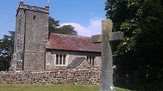
St Nicholas's Church is a parish church in Kimmeridge, Dorset. It is dedicated to St Nicholas of Myra. The church is in the Archdeaconry of Dorset, in the Diocese of Salisbury. The church is of 12th-century origin, much restored and rebuilt in the 19th century. It is Grade II listed.
