
The Mackinac Bridge is a suspension bridge spanning the Straits of Mackinac to connect the Upper and Lower Peninsulas of the U.S. state of Michigan. Opened in 1957, the 26,372-foot-long bridge is the world's 20th-longest main span and the longest suspension bridge between anchorages in the Western Hemisphere. The Mackinac Bridge is part of Interstate 75 and the Lakes Michigan and Huron components of the Great Lakes Circle Tour across the straits; it is also a segment of the U.S. North Country National Scenic Trail. The bridge connects the city of St. Ignace on the north end with the village of Mackinaw City on the south.
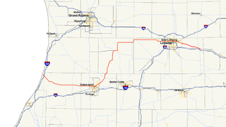
M-43 is a state trunkline highway in southwestern and central parts of the US state of Michigan. The highway runs from South Haven to Webberville along an indirect path through both rural areas and larger cities. The trunkline follows three overall segments: a southeasterly track from South Haven to Kalamazoo, a northeasterly course to the Hastings area and an easterly route through the Lansing area.

M-27 is a north–south state trunkline highway in the extreme north of the Lower Peninsula of the US state of Michigan. The trunkline runs between Interstate 75 (I-75) just north of Indian River and Cheboygan, where it meets US Highway 23 (US 23) near Lake Huron. It remains as a relic of the old US 27 which disappeared north of Grayling after being supplanted by I-75, which lies close to old US 27 between Grayling and Indian River.

M-108 was a state trunkline highway in the US state of Michigan. The highway followed Nicolet Street, although some maps also labeled it as Mackinaw Highway. The road was on the boundary between Emmet and Cheboygan counties.

H-63 is a county-designated highway (CDH) in the Upper Peninsula of the US state of Michigan. The highway parallels the Interstate 75 (I-75) corridor between St. Ignace and Sault Ste. Marie. The road is called Mackinac Trail after the Upper Peninsula branch of an Indian trail used before European settlers reached the area. Originally, the roadway was built as a section of US Highway 2 (US 2) before being added to the CDH system in the 1970s.

M-117 is a 14.479-mile (23.302 km) state trunkline highway in the eastern Upper Peninsula (UP) of the US state of Michigan. The highway connects US Highway 2 (US 2) with M-28 west of Newberry. The designation has been used twice in the UP, once in 1941 for a former section of US 2 between Rexton and Epoufette, and the second in 1949 for the current corridor. The second version included a section that ran north of Newberry along what is now M-123, but it was truncated to its current routing in the 1960s. Since 1993, the trunkline has been dedicated to the 117th Quartermaster Battalion, a former National Guard unit from Kingsford.
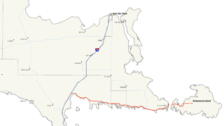
M-134 is a state trunkline highway in the Upper Peninsula (UP) of the US state of Michigan. It connects Interstate 75 (I-75) north of St. Ignace with the communities of Hessel, Cedarville and De Tour Village along Lake Huron. East of De Tour, the highway crosses the De Tour Passage on a ferry to run south of the community of Drummond on Drummond Island. It is one of only three state trunklines in Michigan on islands; the others are M-154 on Harsens Island and M-185 on Mackinac Island. M-134 is also one of only two highways to utilize a ferry in Michigan; the other is US Highway 10 (US 10) which crosses Lake Michigan from Manitowoc, Wisconsin, to Ludington. Most of the mainland portion of M-134 is also part of the Lake Huron Circle Tour, and since 2015, it has been a Pure Michigan Byway under the name M-134 North Huron Byway.

M-123 is a state trunkline highway in the eastern Upper Peninsula of the U.S. state of Michigan. It is one of only a few highways in Michigan that curve around and form a U-shape. In fact, M-123 has three intersections with only two state trunklines; it meets M-28 twice as a result of its U-shaped routing. M-123 also has a rare signed concurrency with a County-Designated Highway in Michigan; in Trout Lake, there is a concurrency with H-40. All of M-123 north of M-28 is a Scenic Heritage Route within the Michigan Heritage Route system.

SS Chief Wawatam was a coal-fired train ferry and icebreaker that operated in the Straits of Mackinac between 1911–1984. Her home port was St. Ignace, Michigan, and she shuttled back and forth during her entire working life between that port and Mackinaw City, Michigan.
Interstate 75 (I-75) is a part of the Interstate Highway System that runs north–south from Miami, Florida, to Sault Ste. Marie in the Upper Peninsula of the US state of Michigan. I-75 enters the state from Ohio in the south, north of Toledo and runs generally northward through Detroit, Pontiac and Bay City, crosses the Mackinac Bridge, and ends at the Canadian border in Sault Ste. Marie. The freeway runs for approximately 396 miles (637 km) on both of Michigan's major peninsulas. The landscapes traversed by I-75 include Southern Michigan farmland, northern forests, suburban bedroom communities, and the urban core of Detroit. The freeway also uses three of the state's monumental bridges to cross major bodies of water. There are four auxiliary Interstates in the state related to I-75, as well as nine current or former business routes, with either Business Loop I-75 or Business Spur I-75 designations.
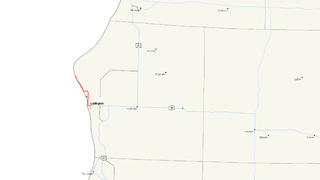
M-116 is a 7.018-mile-long (11.294 km) state trunkline highway in the US state of Michigan that begins in Ludington at an intersection with US Highway 10 (US 10) at James Street and Ludington Avenue. The road travels northward, much of it along the shore of Lake Michigan before reaching its terminus at the entrance to Ludington State Park. The roadway has been in the state highway system since the late 1920s. It has been realigned a few times, most recently in the late 1990s.

M-140 is a north–south state trunkline highway in Berrien and Van Buren counties of the US state of Michigan. The highway starts in the Niles area at M-139 and runs north through Watervliet to South Haven, ending at Interstate 196/US Highway 31 (I-196/US 31). In between, it runs through farm fields and past lakes in the southwestern part of the Lower Peninsula. The trunkline is used, on average, by between 1,500 and 10,200 vehicles.

M-154 is a state trunkline highway in the U.S. state of Michigan. It is entirely on Harsens Island at the mouth of the St. Clair River. It is one of only three trunklines in Michigan on islands. The other two are M-134 on Drummond Island and M-185 on Mackinac Island. Access to Harsens Island and M-154 is provided by ferry which runs year round. The highway was first designated in 1931, and realigned on the island within the next two years.

Vacationland was an automobile ferry that operated in Michigan's Straits of Mackinac between Mackinaw City and St. Ignace from 1952 to 1957, when the Mackinac Bridge was completed.
US Highway 23 (US 23) is a north–south United States Numbered Highway that runs from Jacksonville, Florida, to Mackinaw City, Michigan. In the US state of Michigan, it is a major, 362-mile-long (583 km), north–south state trunkline highway that runs through the Lower Peninsula. The trunkline is a freeway from the Michigan–Ohio state line near Lambertville to the city of Standish, and it follows the Lake Huron shoreline from there to its northern terminus. Serving the cities of Ann Arbor and Flint, US 23 acts as a freeway bypass of the Metro Detroit area. Overall, the highway runs through rural areas of the state dominated by farm fields or woodlands; some segments are urban in character in the Ann Arbor, Flint and Tri-Cities areas. The section from Flint north to Standish also carries Interstate 75 (I-75) along a concurrency that includes a segment that carries almost 70,000 vehicles on a daily basis.
The Mackinac Transportation Company was a train ferry service that shuttled railroad cars across the Straits of Mackinac from 1881 until 1984. It was best known as the owner and operator, from 1911 until 1984, of the SS Chief Wawatam, an icebreaking train ferry.
There have been nine business routes for Interstate 75 in the US state of Michigan. Numbered either Business Loop Interstate 75 or Business Spur Interstate 75 depending if they are a full business loop or a business spur, these highways are former routings of I-75's predecessor highways in the state. They were designated as I-75 was completed through the various areas of Michigan. The business loop in Pontiac runs through that city's downtown along a section of Woodward Avenue and a segment of roadway formerly used by M-24. The former Saginaw business loop was once a part of US Highway 23 (US 23), as was most of the original Bay City business loop. The roadways that make up the business loops in West Branch and Roscommon were previously part of M-76, I-75's predecessor through that part of the state. In Northern Michigan, the Grayling and Gaylord BL I-75s were part of US 27, and the two business routes in St. Ignace and Sault Ste. Marie in the Upper Peninsula of Michigan were part of US 2. A tenth business route, a loop through Indian River has been proposed. Each of the business loops connects to I-75 on both ends and runs through their respective cities' downtown areas. The two business spurs only connect to I-75 on one end and run into the appropriate downtown.


