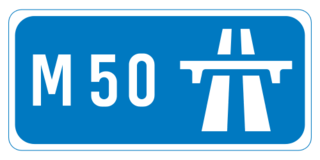
The M50 motorway is a C-shaped orbital motorway in Dublin and the busiest motorway in Ireland. The current route was built in various sections over the course of 27 years, from 1983 to 2010. It begins at Dublin Port, running northward through the Dublin Port Tunnel and along a portion of the Airport Motorway. It then turns west at its junction with the M1, circling the northern, western and southern suburbs of Dublin, before merging with the M11 at Shankill in South East Dublin. The road forms part of European route E01.

Controlled-access highways in Hungary are dual carriageways, grade separated with controlled-access, designed for high speeds. The legislation amendments define two types of highways: motorways and expressways.
Sydney Bypass refers to a number of roads, existing and proposed, that motorists can use to avoid the congested approaches to the Sydney central business district (CBD). The main bypasses are:
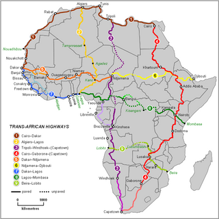
The Trans-African Highway network comprises transcontinental road projects in Africa being developed by the United Nations Economic Commission for Africa (UNECA), the African Development Bank (ADB), and the African Union in conjunction with regional international communities. They aim to promote trade and alleviate poverty in Africa through highway infrastructure development and the management of road-based trade corridors. The total length of the nine highways in the network is 56,683 km (35,221 mi).

Provincial Road 366 is a provincial road in the Canadian province of Manitoba.

In Ireland, the highest category of road is a motorway, indicated by the prefix M followed by a one- or two-digit number. The motorway network consists entirely of motorway-grade dual carriageways and is largely focused upon Dublin. There are also several three-lane motorways, while Ireland's busiest road, the M50, incorporates four-lane, five-lane, and six-lane stretches.
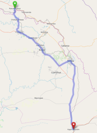
The T3 is a trunk road in Zambia. The road runs from Kapiri Mposhi via Ndola, Kitwe and Chingola to Kasumbalesa on the border with DR Congo. The entire route is a toll road.
The M1 road is a road in Malawi. The road serves as the backbone of Malawi's transportation network, stretching from the country's northern border with Tanzania at Kasumulu all the way down to the southern border with Mozambique at Marka. The north-south artery passes through the capital city of Lilongwe and the commercial hub of Blantyre, covering a total distance of 1,140 kilometers. As the longest road in Malawi, the M1 plays a role in connecting the country's major urban centers and facilitating trade and travel..
The M3 road, also known partially as the Blantyre-Zomba road, is a road in Malawi. The road stretches across the southern region of Malawi, tracing a north-south path that spans 236 kilometers. Beginning in the bustling city of Blantyre, the route winds its way through the scenic landscape to Mangochi, before continuing onward to the Mozambican border at Chiponde, providing a connection between the two countries.

The M22 road is an east–west route located in the northern part of Malawi, connecting the M1 highway to the town of Mzimba. Spanning a total length of 24 kilometers, the road plays a role in linking the key locations in the region.
The M9 road traverses the northwest region of Malawi, stretching from the vicinity of Mzimba to the Tanzanian border at Zepetia. This north-south route offers a link to the country's highlands but bypasses major urban centers. However, the majority of the route is unpaved, consisting of dirt roads that wind through the picturesque landscape.
The M2 is one of the main roads in Malawi. The road works as transportation artery in Malawi, stretching 113 kilometers in east-west direction across the southern region. Beginning in Blantyre, the country's second-largest city, the M2 traverses the scenic landscape to reach the border with Mozambique at Thornwood, providing a link between the two countries.
The M6 is one of the main roads in Malawi. It acts as a transportation link in Malawi, spanning 57 kilometers in east-west direction across the southern region. Beginning at the M1 junction near Zalewa, the M6 traverses the scenic landscape to reach the border with Mozambique near Mwanza, providing a connection between the two nations.
The M7 road is a road in Malawi that stretches 83 kilometers through the heart of the country. The route traverses a north–south trajectory, connecting the region north of the capital city Lilongwe to the town of Mbobo, providing a link between central Malawi's major population centers and economic hubs.
The M8 road is the road in Malawi that serves as an east–west connector in southern Malawi, bridging the gap between the major routes M1 and M3. Spanning 35 kilometers, the road links the towns of Balaka and Liwonde, facilitating efficient travel and trade between the region's important population centers and economic hubs.
The M10 road is a road in Malawi that stretches 19.36 kilometres along the southern shores of Lake Malawi. The key route connects the towns of Mtakataka and Mangochi, providing a link between the region's population centers and economic hubs, and facilitating the flow of trade and commerce across the scenic southern landscape.

Roads in Malawi are an important mode of transport in Malawi. Malawi has 15,451 kilometers of road network by 2016 of which 28% was surfaced. There were 3,357 km of principal roads within the country with majority paved having 2976 km smooth tarmac. A different scenario came in 2014 when a certain report indicated that 38% of tarred routes were top shape, 40% had deteriorated though still passable while the remaining 22% required fixing.
The M12 road is a road in Malawi that spans 119 kilometers that traverses the country from east to west, connecting the capital city of Lilongwe to the Zambian border at Mchinji, providing a transportation artery between the two nations and facilitating the movement of people and goods across the region.
The M14 road is a road in Malawi that serves as an east-west corridor in Malawi's central region, bridging the capital city of Lilongwe with Senga, and providing the main thoroughfare between the capital and the shores of Lake Malawi. Spanning 110 kilometers, this route plays a crucial role in connecting the heart of the country to the lake's stunning natural beauty and economic opportunities.
The M18 road is a road in Malawi that runs about 113 kilometers to connect the town of Kasungu with the lakeside district of Nkhotakota, situated on the scenic shores of Lake Malawi. The east-west route traverses the heart of the country, playing a role in facilitating travel, trade, and commerce between the region's interior and the lake's coastal areas.

