Roads in Malawi are an important mode of transport in Malawi. Malawi has 15,451 kilometers of road network by 2016 of which 28% (4,312 km) was surfaced. There were 3,357 km of principal roads within the country with majority paved having 2976 km smooth tarmac. A different scenario came in 2014 when a certain report indicated that 38% of tarred routes were top shape, 40% had deteriorated though still passable while the remaining 22% required fixing. [1] [2] [3]
Malawi has a well-developed road network especially considering its modest economic status and this could be due to the relatively high population density as compared to other African countries. It features a well-developed paved road infrastructure characterized by the main north-south artery, M1, flanked with parallel branches and few others east-west routes owing to the elongated geography of the country. However, the road conditions often leave much to be desired. In the capital city of Lilongwe, paved roads are scarce, while Blantyre, the largest town, boasts a more urban landscape with a greater number of paved roads. [4] On September 28, 2020, Lilongwe, a clover leaf interchange was sacrificed thus not a complete lack of motorways in Malawi thereby signifying a step ahead in the country’s transportation development. [5] [6]
Malawi’s two biggest towns, Blantyre and Lilongwe, have relatively strong road systems even though they are still inadequate. Majorly, four lane highways and separate lanes are exceptionally rare, however Lilongwe is home to the only southwestern bypass. Lilongwe city center and wealthy neighbourhoods are largely paved whereas poor suburbs have mostly gravel roads. [7] The city also features a relatively high number of roundabouts. Blantyre's road infrastructure shares similarities with Lilongwe, with the notable exception of the M2, which boasts separate carriageways, a unique feature in Malawi until recently. The city had two main urban areas due to its amalgamation with Limbe in 1956. Throughout Malawi’s countryside, new road construction features resemble those found in Europe’s urban areas; they include expanded lanes measuring 9-10 metres to cater for both vehicles and pedestrians as well as circular intersections which point towards upcoming improvement to our transport system. [8] [9]
During the British colonial era, Malawi's road infrastructure saw limited development, with the southern region receiving the most attention. At the time of independence in 1964, the country's modern road network was sparse, with the M3 connecting Blantyre and Zomba being the sole stretch of contemporary paved road. A few other routes, such as the M2 between Blantyre and Mulanje and the M14 between Lilongwe and Salima, featured narrow paved surfaces, but these were exceptions rather than the norm, highlighting the underdeveloped state of Malawi's transportation infrastructure. [10]
Malawi's national road network is categorized into three distinct tiers: main roads, secondary roads, and tertiary roads, each with its own designated numbering system. The main roads serve as the backbone of the network, providing vital connections to major towns and cities across the country. While not always paved, these primary roads are crucial for facilitating transportation and commerce. The M1 stands out as the country's premier road, spanning the length of Malawi from north to south, passing through its largest urban centers and playing a vital role in linking the nation. [11]
During President Hastings Banda's dictatorial rule from 1964 to 1994, Malawi embraced a self-sufficiency philosophy, driven by its landlocked location and lack of raw materials. To stimulate economic growth, the government invested heavily in road development, primarily to facilitate the transportation of agricultural products to urban centers. [12] This led to a rapid expansion of Malawi's road network between the 1960s and 1980s, surpassing that of similarly prosperous nations. Key projects included the paving of the M3-M8-M1 route from Zomba to Lilongwe, followed by sections of the M1 to Mzuzu and Karonga. [13] The 1980s saw a focus on the M5 route along Lake Malawi, which was completed as a paved road in a relatively short period. Additionally, roads in southern Malawi were upgraded, including the M1, M6, and M12, while older narrow roads like the M14 and M2 were modernized. The Road Maintenance and Construction (ROMAC) programs, launched in 1984 and 1992, further enhanced the network, including the upgrading of the M1 to a modern two-lane road and the renovation of older roads. [14] [15] [16]
As Malawi transitioned to democracy in 1994, it boasted a notable 1,820 kilometers of paved roads connecting its towns, supplemented by a modest network of paved city streets. By 2011, the road conditions were relatively stable, with 60% in good shape, 33% fair, and 7% in disrepair. However, the lack of funding led to a rapid decline in road quality, with only 38% in good condition, 40% fair, and 22% in poor shape by the following years. Malawi's road development has largely relied on foreign expertise, with European and Chinese construction companies playing a significant role. Italian, British, and Portuguese firms have been particularly prominent in the country's road construction landscape. Furthermore, international donations and loans from organizations like the African Development Bank, European Union, World Bank, China, Japan International Cooperation Agency, and OPEC Fund have substantially financed Malawi's road projects. [17] [18] [19]
Despite the absence of motorways in Malawi, the country's Highway Code surprisingly includes guidelines on motorway driving, suggesting a potential future intention to develop such high-speed roads. Currently, however, Malawi's road network consists only of smaller highways, urban roads, and rural routes, with no controlled-access motorways. [20]
Malawi has introduced a toll road system, managed by the Roads Fund Administration, to generate revenue for road maintenance and development. [21] Recently, in 2021-2022, toll gates were activated on the M1 highway, a key route connecting Lilongwe and Blantyre. [22] Additionally, foreign-registered vehicles are required to pay a Road Access Fee to use Malawi's roads, further contributing to the country's road infrastructure funding. This dual approach aims to ensure a steady revenue stream for road upkeep and improvements. [22]
Malawi's road network was previously categorized into multiple classes, including Main Roads (M), Secondary Roads (S), District Roads (D), Tertiary Roads, Quaternary Roads, and Minor Roads. In reality, most of these roads were unpaved, with the exception of the Main Roads, which were largely paved. The Main Roads were designated with numbers ranging from M1 to M26, with some numbers omitted. The Secondary Roads were assigned three-digit S-numbers, incrementing from S100 in the north to S152 in the south. Similarly, Tertiary Roads were identified with three-digit T-numbers, increasing from T300 in the north to T426 in the south, creating a systematic hierarchy of road classification.
In Malawi, speed limits are in place to ensure road safety, with a maximum speed of 50 kilometers per hour in urban areas and 80 kilometers per hour in rural areas, providing a clear guideline for drivers to adhere to, and promoting a safe and responsible driving culture throughout the country. [23]
Malawi's road signage system remains somewhat of a mystery, but it is believed to align with the standards set by the South African Development Community (SADC), which draws inspiration from British guidelines. [24] In a bid to harmonize road signs across the region, SADC member states, including Malawi, agreed to standardize road signage in 1995. This initiative culminated in the adoption of the SADC Road Traffic Signs Manual in 1999, providing a unified framework for road signage in the region. [24]
The Malawi Roads Authority (RA) serves as the country's primary road management agency, overseeing the national road network since its establishment in 2006. [25] The RA is responsible for maintaining and developing a vast network of 10,603 kilometers of public roads, encompassing main roads, secondary roads, and tertiary roads, as recorded in 2016. Beyond its national responsibilities, the Malawi Roads Authority also collaborates with local governments to support the development and improvement of local road infrastructure, demonstrating its commitment to comprehensive road network management. [26]
The A2 Highway is a primary road in Zimbabwe running from Harare to Nyamapanda at the border with Mozambique. The Mozambican side border post is called Cochemane. This is a busy entry point used by people travelling by road between South Africa, Malawi, Zimbabwe and Mozambique. It starts at intersection with Samora Machel Avenue; however Enterprise Road itself begins from the T-junction with Robert Mugabe Avenue, opposite the market in Eastlea, east of Simon Muzenda Street Road Port; a bus terminus for inter-regional buses.
Lazarus McCarthy Chakwera is a Malawian politician and theologian who has served as President of Malawi since June 2020. He has served as the leader of the Malawi Congress Party since 2013. He was President of the Malawi Assemblies of God from 1989 to 2013.
The Great Angels Choir is a CCAP gospel musical group from Lilongwe, Malawi. In 2016, the choir shared a stage with American singer, Don Moen. In 2023, it was rumoured that the choir was splitting to which it publicly denied. In September 2023, the choir collaborated with South Africa's Rebecca Malope in performance at the Blessings Gospel Concert at BICC in Lilongwe and other artists. In 2017, the choir hired Sipho Makhabane to spice their website.
Joy Nathu is a Malawian radio DJ, producer, broadcaster and presenter. He won his first UMP Award in 2016 as the DJ of the year. In 2017 and 2018, Nathu also won the same awards and category. He won Radio DJ and Personality of the Year in 2019.
Chiyanjano Muheziwa popularly known as Annie Matumbi, and sometimes Nyakwawa, is a Malawian veteran musician, tv presenter, actor and politician.He has released several successful singles and albums, including "Marshup", "Free Major 1", and "Malawi Must Be Saved". His music has resonated with audiences, making him a household name in Malawi.
National Association for People living with HIV/AIDS in Malawi(NAPHAM) is a Malawian non-governmental member-based organization founded in 1993 aiming at providing a forum for people living with HIV/AIDS in Malawi to share their experiences and find solutions to solve them. The organization was found with an intention to minimised discrimination against people living with HIV/AIDS as at the time people were stigmatized and treated as outcasts when diagnosed with HIV/AIDS.
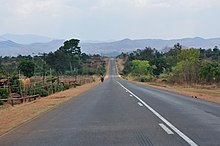
The M1 road is a road in Malawi. The road serves as the backbone of Malawi's transportation network, stretching from the country's northern border with Tanzania at Kasumulu all the way down to the southern border with Mozambique at Marka. The north-south artery passes through the capital city of Lilongwe and the commercial hub of Blantyre, covering a total distance of 1,140 kilometers. As the longest road in Malawi, the M1 plays a role in connecting the country's major urban centers and facilitating trade and travel..
Simama Hotel is a hotel located in Lilongwe, Malawi. It is the country's biggest and most notable hotel after the Sun Bird chain of hotels. The hotel provides facilities and services for the local and middle class business, as well as leisure travelers. The hotel was launched by the Minister of Information, Civic Education and Tourism, Jappie Mhango. The building cost up to MK3.6.
Abraham John Simama is a Malawian businessman, preacher, and philanthropist. He is the founder and CEO of Simama Industries, a conglomerate with interests in the construction, real estate, and agriculture. He is also the senior pastor and the founder of the Glorious Light International Church, which is headquartered in Lilongwe and has written several books on spirituality and leadership. He is the founder of Simama Hotel located in the capital Malawi.
Sunbird Hotels and Resorts or simply Sunbird Hotels, is a Malawian chain of hotels located across the country's cities and towns. It is the country's biggest chain of hotels. The company was incorporated around 1988 as a private institution.
Fredo Penjani Kamlepo Kalua, best known as Fredokiss, is a Malawian rapper and songwriter. In 2020, he was nominated in UMP Award in Best Hip Hop Act and his music video "Dadada" won Music Video of the Year. In 2017, he won three categories namely, Artist of the Year, Best rapper and Best Live Act.
Area 24 is a residential town East of Lilongwe City in Lilongwe District, Malawi and forms part of the Lilongwe municipality. Institutions found in Area 24 include Area 24 College, Area 24 Secondary School and Area 24 Technical Centre. Other neighborhoods of Area 24 include areas 22, 36, Biwi, and Falls.
Angel Mbekeani, best known as Sangie, is a Malawian reggae artist and songwriter. In 2015, she won as the best female artist of the year in UMP Awards. In 2016 and 2019, she was nominated in the same awards in Best Female Artist of the Year. In 2017, she won in the same awards in Best Female Act.
Geoffrey Kapusa was a veteran Malawian television and radio broadcaster and presenter. He was known to have started a television music show called 'Malawi Music Splash' programme on Malawi's MBC state television in early 2000s. He was known as Mr. Splash as a result of his flagship TV music show. Kapusa worked for Malawi Broadcasting Cooperation (MBC) before a brief stint with Times Group.
Chikangawa is a residential and industrial town located in the Mzimba District of Malawi, in the Northern Region. The town has a rich history dating back to the pre-colonial era, when it was a small village inhabited by the Tumbuka people. Chitumbuka is the predominant language spoken in the area.
Edingeni is a residential town in Mzimba, Malawi, southeast Africa. It is located North of Mzimba in the Northern Region. It is a home to Edingeni FC. Chitumbuka is the predominant language spoken in the area which is also the official regional language of the Northern Region of Malawi. The town has a rich history dating back to the pre-colonial era, when it was a small village inhabited by the Tumbuka people.
Lilongwe City Centre is a township that is part of Lilongwe located in the central business district of Lilongwe, the capital city of Malawi. It is situated at the junction of the Old Town and the New City and serves as the commercial and administrative hub of the city.
Kanengo is a township located in the northern part of Lilongwe, the capital city of Malawi. It is situated approximately 10 kilometers north of the city center.
Lilongwe City Council (LCC) is the municipal government of Lilongwe, the capital city of Malawi. The council was established in 1998 and is responsible for providing services such as infrastructure development and maintenance, waste management, public health services, environmental conservation, land use planning and management, and economic development and investment promotion. The council is headed by a mayor and has a team of councillors and staff who work together to deliver services to the residents of Lilongwe. The council's goal is to make Lilongwe a better place to live, work and invest. It strives to provide quality services, promote economic growth and enhance the quality of life for all citizens.
The M7 road is a road in Malawi that stretches 83 kilometers through the heart of the country. The route traverses a north–south trajectory, connecting the region north of the capital city Lilongwe to the town of Mbobo, providing a link between central Malawi's major population centers and economic hubs.
{{cite web}}
: External link in |website=
(help){{cite web}}
: CS1 maint: numeric names: authors list (link){{cite web}}
: CS1 maint: numeric names: authors list (link)Media related to Roads in Malawi at Wikimedia Commons