Transportation in Malawi is poorly developed. The country of almost 14 million has 39 airports, 6 with paved runways and 33 with unpaved runways. It has 797 kilometres of railways, all narrow-gauge and about 45 percent of its roads are paved. Though it is landlocked, Malawi also has 700 km (435 mi) of waterways on Lake Malawi and along the Shire River.

Lilongwe is the capital and largest city of Malawi. It has a population of 989,318 as of the 2018 Census, up from a population of 674,448 in 2008. In 2020 that figure was 1,122,000. The city is located in the central region of Malawi, in the district of the same name, near the borders with Mozambique and Zambia, and it is an important economic and transportation hub for central Malawi. It is named after the Lilongwe River.
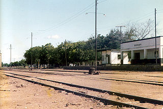
Mchinji is a town and the capital of the Mchinji District in the Central Region of Malawi. Mchinji Boma, located 12 kilometres from the Zambian border and 109 km (68 mi) from the national capital, Lilongwe, is the major hub of government and general business. It has a major railroad junction, being the railhead nearest to Zambia. The area's economy is sustained by rain-fed agriculture.

The Central Region of Malawi, population 7,523,340 (2018), covers an area of 35,592 km2. Its capital city is Lilongwe, which is also the national capital. The region has an outlet on Lake Malawi and borders neighbouring countries Zambia and Mozambique. The Chewa people make up the majority of the population today.

Chipata is a city and administrative centre of the Eastern Province of Zambia and Chipata District. It was declared the 5th city of the country, after Lusaka, Ndola, Kitwe and Livingstone, by President Edgar Lungu on 24 February 2017. The city has undergone rapid economic and infrastructure growth in the years, leading up to city status.

The Great East Road is a major road in Zambia and the main route linking its Eastern Province with the rest of the country. It is also the major link between Zambia and Malawi and between Zambia and northern Mozambique. However, the route does not carry as much traffic as many of the other regional arterial roads and between the main cities it serves, Lusaka and Chipata, it passes through rural and wilderness areas. In Lusaka the road forms the main arterial road for the eastern suburbs. The entire route from Lusaka to Chipata and the border with Malawi is designated the T4 road on Zambia's road network.
Malawi Railways was a government corporation that ran the national rail network of Malawi, Africa, until privatisation in 1999. With effect from 1 December 1999, the Central East African Railways consortium led by Railroad Development Corporation won the right to operate the network. This was the first rail privatisation in Africa which did not involve a parastatal operator.

Chipata District is a district of Zambia, located in Eastern Province. The capital lies at Chipata. As of the 2010 Zambian Census, the district had a population of 455,783 people.

Sena railway, also called Shire Highlands railway, Dondo-Malawi railway and North-South Malawi railway, is a railway that connects Dondo, Mozambique, to Chipata, in Zambia. It is c. 1000 km long, in a 1067 mm gauge.
Mwami is a town in the Eastern Province of Zambia. The town lies at the international border with Malawi, adjacent to the Malawian city of Mchinji.

The M1 road is a road in Malawi. The road serves as the backbone of Malawi's transportation network, stretching from the country's northern border with Tanzania at Kasumulu all the way down to the southern border with Mozambique at Marka. The north-south artery passes through the capital city of Lilongwe and the commercial hub of Blantyre, covering a total distance of 1,140 kilometers. As the longest road in Malawi, the M1 plays a role in connecting the country's major urban centers and facilitating trade and travel.
The M3 road, also known partially as the Blantyre-Zomba road, is a road in Malawi. The road stretches across the southern region of Malawi, tracing a north-south path that spans 236 kilometers. Beginning in the bustling city of Blantyre, the route winds its way through the scenic landscape to Mangochi, before continuing onward to the Mozambican border at Chiponde, providing a connection between the two countries.
The M9 road traverses the northwest region of Malawi, stretching from the vicinity of Mzimba to the Tanzanian border at Zepetia. This north-south route offers a link to the country's highlands but bypasses major urban centers. However, the majority of the route is unpaved, consisting of dirt roads that wind through the picturesque landscape.
The M2 is one of the main roads in Malawi. The road works as transportation artery in Malawi, stretching 113 kilometers in east-west direction across the southern region. Beginning in Blantyre, the country's second-largest city, the M2 traverses the scenic landscape to reach the border with Mozambique at Thornwood, providing a link between the two countries.
The M6 is one of the main roads in Malawi. It acts as a transportation link in Malawi, spanning 57 kilometers in east-west direction across the southern region. Beginning at the M1 junction near Zalewa, the M6 traverses the scenic landscape to reach the border with Mozambique near Mwanza, providing a connection between the two nations.
The M7 road is a road in Malawi that stretches 83 kilometers through the heart of the country. The route traverses a north–south trajectory, connecting the region north of the capital city Lilongwe to the town of Mbobo, providing a link between central Malawi's major population centers and economic hubs.
The M10 road is a road in Malawi that stretches 19.36 kilometres along the southern shores of Lake Malawi. The key route connects the towns of Mtakataka and Mangochi, providing a link between the region's population centers and economic hubs, and facilitating the flow of trade and commerce across the scenic southern landscape.

Roads in Malawi are an important mode of transport in Malawi. Malawi has 15,451 kilometers of road network as of 2016 of which 28% was surfaced. There were 3,357 km of principal roads within the country with majority paved having 2976 km smooth tarmac. A different scenario came in 2014 when a certain report indicated that 38% of tarred routes were top shape, 40% had deteriorated though still passable while the remaining 22% required fixing.
The M14 road is a road in Malawi that serves as an east-west corridor in Malawi's central region, bridging the capital city of Lilongwe with Senga, and providing the main thoroughfare between the capital and the shores of Lake Malawi. Spanning 110 kilometers, this route plays a crucial role in connecting the heart of the country to the lake's stunning natural beauty and economic opportunities.
The M16 road is a road in Malawi spanning a concise 8.23 kilometers to form an east-west connection in the country's central region. Situated north of the Lilongwe area, this road plays a role in facilitating travel and commerce across the heart of Malawi, providing a transportation link between neighboring towns and villages.

