Nkhotakota (Un-kho-tah-kho-tuh) is a town and one of the districts in the Central Region of Malawi. It is on the shore of Lake Malawi and is one of the main ports on Lake Malawi. As of 2018, Nkhotakota had a population estimated at 28,350. The district had a population of 301,000.

The Central Region of Malawi, population 7,523,340 (2018), covers an area of 35,592 km2. Its capital city is Lilongwe, which is also the national capital. The region has an outlet on Lake Malawi and borders neighbouring countries Zambia and Mozambique. The Chewa people make up the majority of the population today.
Liwonde National Park, also known as Liwonde Wildlife Reserve, is a national park in southern Malawi, near the Mozambique border. The park was established in 1973, and has been managed by the nonprofit conservation organization African Parks since August 2015. African Parks built an electric fence around the perimeter of the park to help mitigate human-wildlife conflict. In early 2018, the adjacent Mangochi Forest Reserve was also brought under African Parks' management, almost doubling the size of the protected area.

Vermont Route 17 (VT 17) is a 40.409-mile-long (65.032 km) state highway in western Vermont in the United States. The western terminus of the route is at the New York state line in Addison, where it connects to New York State Route 185 (NY 185) by way of the Lake Champlain Bridge. Its eastern terminus is at a junction with VT 100 in Waitsfield. VT 17 was initially much shorter than it is today, extending from the Champlain Bridge to Addison upon assignment. It was extended east through the Green Mountains to Waitsfield in 1965.

Highway 35 is a paved, undivided provincial highway in the Canadian province of Saskatchewan. It runs from the U.S. border at the Port of Oungre north to a dead end near the north shore of Tobin Lake. The southern end of Highway 35 is one segment of the CanAm Highway, which is an international highway connecting Canada, the United States, and Mexico. Highway 35 is about 569 kilometres (354 mi) long.
Highway 9 is a paved, undivided provincial highway in the Canadian province of Saskatchewan. It runs from North Dakota Highway 8 at the US border near Port of Northgate until it transitions into Provincial Road 283 at the Manitoba provincial boundary.
The Saskota Flyway is known as the International Road to Adventure, because it takes you from Hudson Bay, Saskatchewan, all the way south to Bismarck, North Dakota.

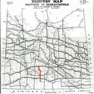
Highway 58 is a provincial highway in the Canadian province of Saskatchewan that handles approximately 100 vehicles per day. The highway runs from Highway 18 about 3 kilometres (1.9 mi) west of Fir Mountain north until Highway 1 / Highway 19 at Chaplin in the south-central region of the province. There are multiplexes of 1.6 kilometres (1.0 mi) with Highway 13, 300 metres (980 ft) with Highway 43, and 4.9 kilometres (3.0 mi) with Highway 363. The section from its southern terminus north to Shamrock is paved while north of Shamrock to Chaplin is gravel. The highway is about 132 kilometres (82 mi) long.

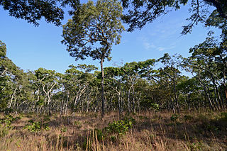
Nkhotakota Wildlife Reserve, is the largest and oldest wildlife reserve in Malawi, near Nkhotakota. The park's hilly terrain features dambos and miombo woodlands as the dominant vegetation, which support a variety of mammal and bird species. Poaching has greatly reduced the number of elephants and other large mammals in Nkhotakota, but conservation efforts to restore the elephant population started when African Parks began managing the reserve in 2015.
Chintheche is a settlement in the Nkhata Bay District of the Northern Region of Malawi. It is on the shore of Lake Malawi, and is approximately 40 kilometres (25 mi) south of Nkhata Bay. The town is close to the main road between Nkhata Bay and Nkhotakota.

The Central Zambezian miombo woodlands ecoregion spans southern central Africa. Miombo woodland is the predominant plant community. It is one of the largest ecoregions on the continent, and home to a great variety of wildlife, including many large mammals.
The M1 road is a road in Malawi. The road serves as the backbone of Malawi's transportation network, stretching from the country's northern border with Tanzania at Kasumulu all the way down to the southern border with Mozambique at Marka. The north-south artery passes through the capital city of Lilongwe and the commercial hub of Blantyre, covering a total distance of 1,140 kilometers. As the longest road in Malawi, the M1 plays a role in connecting the country's major urban centers and facilitating trade and travel..
The M3 road, also known partially as the Blantyre-Zomba road, is a road in Malawi. The road stretches across the southern region of Malawi, tracing a north-south path that spans 236 kilometers. Beginning in the bustling city of Blantyre, the route winds its way through the scenic landscape to Mangochi, before continuing onward to the Mozambican border at Chiponde, providing a connection between the two countries.
The M9 road traverses the northwest region of Malawi, stretching from the vicinity of Mzimba to the Tanzanian border at Zepetia. This north-south route offers a link to the country's highlands but bypasses major urban centers. However, the majority of the route is unpaved, consisting of dirt roads that wind through the picturesque landscape.
The M6 is one of the main roads in Malawi. It acts as a transportation link in Malawi, spanning 57 kilometers in east-west direction across the southern region. Beginning at the M1 junction near Zalewa, the M6 traverses the scenic landscape to reach the border with Mozambique near Mwanza, providing a connection between the two nations.
The M7 road is a road in Malawi that stretches 83 kilometers through the heart of the country. The route traverses a north–south trajectory, connecting the region north of the capital city Lilongwe to the town of Mbobo, providing a link between central Malawi's major population centers and economic hubs.
The M10 road is a road in Malawi that stretches 19.36 kilometres along the southern shores of Lake Malawi. The key route connects the towns of Mtakataka and Mangochi, providing a link between the region's population centers and economic hubs, and facilitating the flow of trade and commerce across the scenic southern landscape.
The T28 is a Trunk Road in Tanzania. The road serves as a brief but crucial link between Kasumulu and Kyela, located in the border region with Malawi, providing access to a ferry terminal on the shores of Lake Malawi. Spanning a total distance of 25 kilometers, theroad plays a role in connecting the surrounding areas to the lake's transportation network.
The M12 road is a road in Malawi that spans 119 kilometers, the M12 road traverses the country from east to west, connecting the capital city of Lilongwe to the Zambian border at Mchinji, providing a transportation artery between the two nations and facilitating the movement of people and goods across the region.
The M14 road is a road in Malawi that serves as an east-west corridor in Malawi's central region, bridging the capital city of Lilongwe with Senga, and providing the main thoroughfare between the capital and the shores of Lake Malawi. Spanning 110 kilometers, this route plays a crucial role in connecting the heart of the country to the lake's stunning natural beauty and economic opportunities.


