
Yonge Street is a major arterial route in the Canadian province of Ontario connecting the shores of Lake Ontario in Toronto to Lake Simcoe, a gateway to the Upper Great Lakes. Ontario's first colonial administrator, John Graves Simcoe, named the street for his friend Sir George Yonge, an expert on ancient Roman roads.
Zomba is a city in southern Malawi, in the Shire Highlands. It is the former capital city of Malawi.

Mangochi is a township in the Southern Region of Malawi. Located near the southern end of Lake Malawi, in colonial times it used to be called Fort Johnston. As of 2018, it has a population of 53,498.
Monkey Bay or Lusumbwe is a town in Mangochi which is in the Mangochi District in the Southern Region of Malawi. The town is on the shore of Lake Malawi and is one of the main ports on Lake Malawi. The population of Monkey Bay was 14,955 according to the 2018 census. Monkey Bay is 206 kilometres (128 mi) from Lilongwe, Malawi's capital city, and 253 kilometres (157 mi) from Blantyre. Monkey Bay is a tourist resort and is often travelled through on the road to Cape Maclear.

The Trans-Labrador Highway (TLH) is the primary public road in Labrador, the mainland portion of the province of Newfoundland and Labrador, Canada. The highway's total length is 1,149 km (714 mi). The paving of the entire highway was completed in July 2022.
The Mangochi District is a hub of commerce. It is a transit point, with roads leading to all areas of Malawi and Mozambique to the east. In fact, the border is not far once you cross the Shire River. To the north, the road bifurcates into the Salima or Monkey Bay roads. To the west, is the hilly region of Dedza. Traveling south, the road climbs up the Machinga escarpment to Zomba, the former colonial capital of Nyasaland, and from there to Malawi's commercial hub of Blantyre. It is fiercely hot in summer and ambient in winter. It is on the flood-plain for Lake Malawi. The lake is the third largest and most southerly in the Rift Valley lake system, and is unofficially known as the Lake of Stars. The lake was named by David Livingston as he discovered it on September 18, 1859, for the effect of the reflection of the sun on the water's surface. It is also known as the Calendar Lake as it is approx 365 miles (587 km) long and 52 wide.
Liwonde National Park, also known as Liwonde Wildlife Reserve, is a national park in southern Malawi, near the Mozambique border. The park was established in 1973, and has been managed by the nonprofit conservation organization African Parks since August 2015. African Parks built an electric fence around the perimeter of the park to help mitigate human-wildlife conflict. In early 2018, the adjacent Mangochi Forest Reserve was also brought under African Parks' management, almost doubling the size of the protected area.

Nkhata Bay or just Nkhata is the capital of the Nkhata Bay District in Malawi. It is on the shore of Lake Malawi, east of Mzuzu, and is one of the main ports on Lake Malawi. The population of Nkhata Bay was 14,274 according to the 2018 census. Nkhata Bay is 413 kilometres (257 mi) from Lilongwe, Malawi's capital city, and 576 kilometres (358 mi) from Blantyre, Malawi's second-largest city. Nkhata Bay is the second "busiest resort" on Lake Malawi.

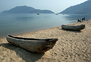
Cape Maclear or Chembe is a town in the Mangochi District of Malawi's Southern Region. The town, on the Nankumba Peninsula, is on the southern shore of Lake Malawi and is the busiest resort on Lake Malawi. Cape Maclear is close to the islands of Domwe, Thumbwe and Mumbo Island on Lake Malawi, and is in Lake Malawi National Park.

State Highway 6 is a major New Zealand state highway. It extends from the Marlborough region in the northeastern corner of the South Island across the top of the island, then down the length of the island, initially along the West Coast and then across the Southern Alps through inland Otago and finally across the Southland Plains to the island's south coast. Distances are measured from north to south.
Chilumba is a town in Malawi. It is an urban centre in Karonga District.
Malindi is a town in the Mangochi District, in the Southern Region of Malawi.
The M10 road is a road in Zambia. It goes from Livingstone, through Sesheke and Senanga, to Mongu. The road is approximately 508 kilometres and follows the Zambezi River for its entire length.

Sena railway, also called Shire Highlands railway, Dondo-Malawi railway and North-South Malawi railway, is a railway that connects Dondo, Mozambique, to Chipata, in Zambia. It is c. 1000 km long, in a 1067 mm gauge.
The Lirangwe–Chingale–Machinga Road is a road in the Southern Region of Malawi, connecting the towns of Lirangwe in Blantyre District to the towns of Chingale in Zomba District and the town of Machinga in Machinga District.
The M1 road is a road in Malawi. The road serves as the backbone of Malawi's transportation network, stretching from the country's northern border with Tanzania at Kasumulu all the way down to the southern border with Mozambique at Marka. The north-south artery passes through the capital city of Lilongwe and the commercial hub of Blantyre, covering a total distance of 1,140 kilometers. As the longest road in Malawi, the M1 plays a role in connecting the country's major urban centers and facilitating trade and travel..
The M3 road, also known partially as the Blantyre-Zomba road, is a road in Malawi. The road stretches across the southern region of Malawi, tracing a north-south path that spans 236 kilometers. Beginning in the bustling city of Blantyre, the route winds its way through the scenic landscape to Mangochi, before continuing onward to the Mozambican border at Chiponde, providing a connection between the two countries.
The M9 road traverses the northwest region of Malawi, stretching from the vicinity of Mzimba to the Tanzanian border at Zepetia. This north-south route offers a link to the country's highlands but bypasses major urban centers. However, the majority of the route is unpaved, consisting of dirt roads that wind through the picturesque landscape.
The M11 road is a road in Malawi that stretches about 12.96 kilometers along the shores of Lake Malawi, connecting Timbiri and Chiweta. However, the road's development has stalled, leaving a substantial gap in its route. While some sections exist as dirt roads or tracks, a significant portion of the M11 remains a missing link, hindering the creation of a seamless north–south passage along the lake's scenic shoreline.

Roads in Malawi are an important mode of transport in Malawi. Malawi has 15,451 kilometers of road network by 2016 of which 28% was surfaced. There were 3,357 km of principal roads within the country with majority paved having 2976 km smooth tarmac. A different scenario came in 2014 when a certain report indicated that 38% of tarred routes were top shape, 40% had deteriorated though still passable while the remaining 22% required fixing.

