Monkey Bay

Last updated

Monkey Bay

Lusumbwe
Monoxylon beach Lake Malawi 1557.jpg
Beach at Cape Maclear near Monkey Bay
Malawi adm location map.svg
Red pog.svg
Monkey Bay
Location in Malawi
Coordinates: 14°05′00″S34°55′00″E / 14.08333°S 34.91667°E / -14.08333; 34.91667
CountryFlag of Malawi.svg  Malawi
Region Southern Region
District Mangochi District
Elevation
1,630 ft (500 m)
Population
 (2018 Census [1] )
  Total14,955
Time zone +2
Climate Aw
Main north-south street of the town. Monkey bay main road.JPG
Main north-south street of the town.

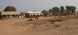
Monkey Bay or Lusumbwe is a town in Mangochi which is in the Mangochi District in the Southern Region of Malawi. The town is on the shore of Lake Malawi and is one of the main ports on Lake Malawi. [2] The population of Monkey Bay was 14,955 according to the 2018 census. [3] Monkey Bay is 206 kilometres (128 mi) from Lilongwe, Malawi's capital city, and 253 kilometres (157 mi) from Blantyre. [4] Monkey Bay is a tourist resort and is often travelled through on the road to Cape Maclear. [5]

Contents

History

Monkey Bay was ruled by the Muslim Yao chief and slave trader, Mponda, during the 1880s. [6] In the late 19th century, the first Bishop of Likoma, Chauncy Maples, drowned near Monkey Bay in Lake Malawi. [7] In the 1960s, there was a Fisheries Research Laboratory in Monkey Bay, funded by the then-Nyasaland colonial government. [8]

Geography

Monkey Bay is on the shore of Lake Malawi and is one of the main ports on Lake Malawi. [2] It is at an elevation of 500 m (1,630 ft).

Monkey Bay is situated 6 km (4 mi) from Chimpamba, 3 km (2 mi) from Zambo, 1.5 km (1 mi) from Msumbi and 800 m (12 mi) from Mbalamanja. [9]

Living standards

In March 2003, the then-Malawian President Bakili Muluzi held a rally in Monkey Bay, and promised to help reduce poverty. [10] The charity Save the Children is active in the Monkey Bay area. [11] According to a German development volunteer working with the Back to School Foundation, the residents of Monkey Bay are not living at the poverty line, but at the existence line. Houses are simple clay cottages, and few households can afford electricity, as the connection costs alone are three times the average monthly wage. [12]

Facilities

Amenities

There is a supermarket and a market in Monkey Bay, although there are bureaux de change or automatic teller machines. On 22 February 2010, a first bank opened its doors. Malawi Savings Bank Agency which was operating from the Post Office building moved into their own convenience, a refurbished and spacious building at the trading centre.

There is not a functioning internet café although there are signs for one. There are several guesthouses. [13] The nearest ATM is in the town of Mangochi.

Transport

Monkey Bay is connected to Lilongwe and Blantyre by bus services. [13] The nearest airport is at Ulongwe, 79 km (49 mi) away. [9] Two passenger ferries make weekly sailings along Lake Malawi between Monkey Bay and Chilumba; the MV Ilala and the Mtendere. [14] The Ilala is 350-passenger steamship that has served the route since 1951. [15] In March 2003, the European Union funded improvements to the road linking Monkey Bay with Masasa and Golomoti. [16] In February 2006, the Malawian government announced plans to build a road from Monkey Bay to Cape Maclear. [17] In March 2006, there was no road access to Monkey Bay, after the worst floods since 1978 had washed away several kilometres of road and a bridge. [18] The rainfall measured around 158 millimetres (6.2 in) and several thousand people in the Mangochi District were made homeless. [19]

Education

The Nankhwala Catholic School is in Monkey Bay. [20]

Medical

Monkey Bay has a hospital, but medical services are not extensive; surgery and diagnostics are however available in Monkey Bay. [21]

Law and military

Monkey Bay has a police station. It is also the headquarters of the 220-strong marine force of the Army of Malawi. [22] [23]

Tourism

Monkey Bay has been described as "the country's best known resort" by Agence France-Presse , [18] and Factiva refers to Monkey Bay as the "best known resort-area" in Malawi. [24] The area has "sandy beaches and tropical fish", [19] and is popular with tourists. [22] There are diving schools in Monkey Bay, however, according to the Daily Telegraph, the schools are considered poor by tourists. [25] The town is also a transit point to Cape Maclear.

Demographics

YearPopulation [3] [1]
19875,649
199810,749
200811,246
201814,955

Related Research Articles

The History of Malawi covers the area of present-day Malawi. The region was once part of the Maravi Empire. In colonial times, the territory was ruled by the British, under whose control it was known first as British Central Africa and later Nyasaland. It became part of the Federation of Rhodesia and Nyasaland. The country achieved full independence, as Malawi, in 1964. After independence, Malawi was ruled as a one-party state under Hastings Banda until 1994.

Transport in Malawi

Transportation in Malawi is poorly developed. The country of almost 14 million has 39 airports, 6 with paved runways and 33 with unpaved runways. It has 797 kilometres of railways, all narrow-gauge and about 45 percent of its roads are paved. Though it is landlocked, Malawi also has 700 km (435 mi) of waterways on Lake Malawi and along the Shire River.

Zomba, Malawi Place in Southern Region, Malawi

Zomba is a city in southern Malawi, in the Shire Highlands. It is the former capital city of Malawi.

Karonga Place in Northern Region, Malawi

Karonga is a township in the Karonga District in Northern Region of Malawi. Located on the western shore of Lake Nyasa, it was established as a slaving centre sometime before 1877. As of 2018 estimates, Karonga has a population of 61,609.

Kasungu Place in Central Region, Malawi

Kasungu is a town in the Kasungu District of the Central Region of Malawi. The population of Kasungu was 58,653 according to the 2018 census. Kasungu is approximately 130 kilometres (81 mi) north-west of the capital of Malawi, Lilongwe, and is 35 kilometres (22 mi) east of Kasungu National Park. The main industry in Kasungu is tobacco-growing.

Mchinji Place in Central Region, Malawi

Mchinji is a town and the capital of the Mchinji District in the Central Region of Malawi. Mchinji Boma, located 12 kilometres from the Zambian border and 109 km (68 mi) from the national capital, Lilongwe, is the major hub of government and general business. It has a major railroad junction, being the railhead nearest to Zambia. The area's economy is sustained by rain-fed agriculture.

Nkhotakota Place in Central Region, Malawi

Nkhotakota (Un-kho-tah-kho-tuh) is a town and one of the districts in the Central Region of Malawi. It is on the shore of Lake Malawi and is one of the main ports on Lake Malawi. As of 2018, Nkhotakota had a population estimated at 28,350. The district had a population of 301.000.

Mangochi Place in Southern Region, Malawi

Mangochi is a township in the Southern Region of Malawi. Located near the southern end of Lake Malawi, in colonial times it used to be called Fort Johnston. As of 2018 it has a population of 53,498.

Likoma Island

Likoma Island is the larger of two islands in Lake Malawi, in East Africa, the smaller being the nearby Chizumulu. Likoma and Chizumulu both belong to Malawi, and together they make up the Likoma District. Although both islands lie just a few kilometres from Mozambique, and are entirely surrounded by Mozambican territorial waters, they are both exclaves of Malawi.

Mangochi District is one of twelve districts in the Southern Region of Malawi. The capital is Mangochi. The district covers an area of 6,273 km.² and has a population of 610,239.

Liwonde National Park

Liwonde National Park, also known as Liwonde Wildlife Reserve, is a national park in southern Malawi, near the Mozambique border. The park was established in 1973, and has been managed by the nonprofit conservation organization African Parks since August 2015. African Parks built an electric fence around the perimeter of the park to help mitigate human-wildlife conflict. In early 2018, the adjacent Mangochi Forest Reserve was also brought under African Parks' management, almost doubling the size of the protected area.

Nkhata Bay Place in Northern Region, Malawi

Nkhata Bay or just Nkhata is the capital of the Nkhata Bay District in Malawi. It is on the shore of Lake Malawi, east of Mzuzu, and is one of the main ports on Lake Malawi. The population of Nkhata Bay was 14,274 according to the 2018 census. Nkhata Bay is 413 kilometres (257 mi) from Lilongwe, Malawi's capital city, and 576 kilometres (358 mi) from Blantyre, Malawi's second-largest city. Nkhata Bay is the second "busiest resort" on Lake Malawi.

MV <i>Ilala</i> Motor ship based in Lake Malawi, East Africa

MV Ilala, formally Ilala II, is a motor ship that has plied Lake Malawi in East Africa since 1951. Every week she crosses the lake all the way north to Chilumba, Malawi, near Tanzania and then returns to Monkey Bay. She carries both passengers and freight, and calls at major towns on both the Malawian and Mozambican coast, as well as at two islands of the lake.

Cape Maclear Place in Southern Region, Malawi

Cape Maclear or Chembe is a town in the Mangochi District of Malawi's Southern Region. The town, situated on the Nankumba Peninsula, is on the southern shore of Lake Malawi and is the busiest resort on Lake Malawi. Cape Maclear is close to the islands of Domwe and Thumbwe on Lake Malawi, and is in Lake Malawi National Park.

Malawi, officially known as the Republic of Malawi, is a country located in southeastern Africa. The country is also referred to as "The Warm Heart of Africa", due to the friendliness of the people.

Chintheche Place in Northern Region, Malawi

Chintheche is a settlement in the Nkhata Bay District of the Northern Region of Malawi. It is on the shore of Lake Malawi, and is approximately 40 kilometres (25 mi) south of Nkhata Bay. The town is close to the main road between Nkhata Bay and Nkhotakota.

Cuthy Mede is a Malawian artist.

Lake Malawi Museum is a museum on Lake Malawi in Malawi. Situated in the Old Gymkhana Club and organized by the Society of Malawi since 1971, the museum is located near the Queen Victoria memorial near the Bakili Muluzi Bridge in Mangochi town, Mangochi District, within the Southern Region of Malawi.

Pemba Bay

Pemba Bay is a very large bay on the Indian Ocean of northeastern Mozambique.

The Lirangwe–Chingale–Machinga Road is a road in the Southern Region of Malawi, connecting the towns of Lirangwe in Blantyre District to the towns of Chingale in Zomba District and the town of Machinga in Machinga District.

References

  1. 1 2 "2018 Population and Housing Census Main Report" (PDF). Malawi National Statistical Office. Retrieved 25 December 2019.
  2. 1 2 "Malawi: Transportation". Encyclopædia Britannica . Retrieved 20 June 2008.
  3. 1 2 "World Gazetteer: Malawi: largest cities and towns and statistics of their population". World Gazetteer. Archived from the original on 27 September 2007. Retrieved 20 June 2008.
  4. "Malawi distance table". Archived from the original on 8 September 2008. Retrieved 20 June 2008.
  5. Murphy, Alan; Armstrong, Kate; Firestone, Matthew D.; Fitzpatrick, Mary (2007). Lonely Planet Southern Africa: Join the Safari. Lonely Planet. p. 200. ISBN   1-74059-745-1 . Retrieved 20 June 2008.
  6. Good, Charles M. (2004). The Steamer Parish: The Rise and Fall of Missionary Medicine on an African . University of Chicago Press. p.  88. ISBN   0-226-30281-4 . Retrieved 22 June 2008.
  7. Murphy, Alan; Armstrong, Kate; Firestone, Matthew D.; Fitzpatrick, Mary (2007). Lonely Planet Southern Africa: Join the Safari. Lonely Planet. p. 193. ISBN   1-74059-745-1 . Retrieved 20 June 2008.
  8. Bulletin – Malawi Geological Survey Department. Malawi Geographical Survey Department. 1963. Retrieved 20 June 2008.
  9. 1 2 "Maps, Weather, and Airports for Monkey Bay, Malawi". FallingRain Genomics. Retrieved 21 June 2008.
  10. "Malawi: Muluzi Outlines Priority". AllAfrica . 8 March 2008. Retrieved 20 June 2008.
  11. Itano, Nicole (11 June 2002). "AIDS adds to African food crisis". CS Monitor . Retrieved 20 June 2008.
  12. Kleinebrahm, Tobias (23 August 2007). "Eine Zukunft für die Kinder von Malawi". Rheinische Post (in German). Archived from the original on 20 February 2013. Retrieved 20 June 2008.
  13. 1 2 Murphy, Alan; Armstrong, Kate; Firestone, Matthew D.; Fitzpatrick, Mary (2007). Lonely Planet Southern Africa: Join the Safari. Lonely Planet. p. 201. ISBN   1-74059-745-1 . Retrieved 20 June 2008.
  14. Rogers, Douglas (5 February 2001). "Malawi: On a mission in Africa". The Daily Telegraph . Archived from the original on 5 September 2008. Retrieved 20 June 2008.
  15. "Lake placid". The Guardian . 18 April 2001. Retrieved 20 June 2008.
  16. Chimwala, Marcel (28 March 2003). "EU approves funding for Malawian road projects" . Retrieved 20 June 2008.
  17. "Malawi: Investors, Tourists Wear Smile in Cape Maclear". AllAfrica . 28 February 2006. Retrieved 20 June 2008.
  18. 1 2 "Flash floods in Malawi tourist haven leave 6,000 homeless". Agence France Presse. 8 March 2006. Retrieved 20 June 2008.
  19. 1 2 "Heavy flooding causes havoc in Malawi". AngolaPress. 22 March 2008. Retrieved 20 June 2008.[ permanent dead link ]
  20. "School cash for Malawi youngsters". BBC News . 12 June 2006. Retrieved 20 June 2008.
  21. Collins, Dr. Martina (10 June 2008). "Life as a GP in Malawi —the warm heart of Africa". Irish Medical Times . Archived from the original on 2 June 2009. Retrieved 20 June 2008.
  22. 1 2 "Divers search for bodies in Lake Malawi". Independent Online . 10 April 2008. Retrieved 20 June 2008.
  23. Wertheim, Eric (2007). The Naval Institute Guide to Combat Fleets of the World: Their Ships, Aircraft and Systems. Naval Institute Press. p. 452. ISBN   1-59114-955-X . Retrieved 20 June 2008.
  24. "Floods cause chaos in Malawi, Mozambique". Factiva. 10 March 2006. Retrieved 20 June 2008.
  25. Isaacson, Rupert (5 February 2001). "Malawi: Flying under water". The Daily Telegraph . Retrieved 20 June 2008.[ dead link ]

Coordinates: 14°05′S34°55′E / 14.083°S 34.917°E / -14.083; 34.917