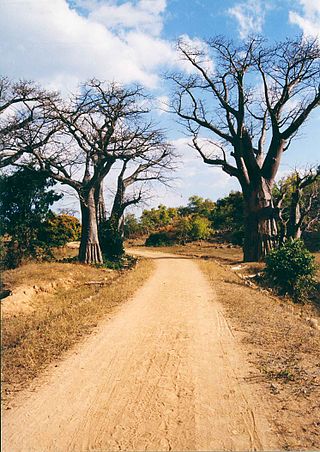
Transportation in Malawi is poorly developed. The country of almost 14 million has 39 airports, 6 with paved runways and 33 with unpaved runways. It has 797 kilometres of railways, all narrow-gauge and about 45 percent of its roads are paved. Though it is landlocked, Malawi also has 700 km (435 mi) of waterways on Lake Malawi and along the Shire River.

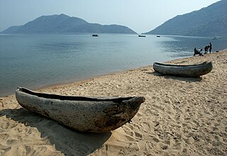
Lake Malawi, also known as Lake Nyasa in Tanzania and Lago Niassa in Mozambique, is an African Great Lake and the southernmost lake in the East African Rift system, located between Malawi, Mozambique and Tanzania.

Entebbe is a city in Central Uganda which is located on Lake Victoria peninsula, approximately 36 kilometres (22 mi) southwest of the Ugandan capital city, Kampala. Entebbe was once the seat of government for the Protectorate of Uganda prior to independence, in 1962. The city is the location of Entebbe International Airport, Uganda's largest commercial and military airport, which gained worldwide attention in 1976 Israeli rescue of 100 hostages kidnapped by the militant group of the PFLP-EO and Revolutionary Cells (RZ) organizations. Entebbe is also the location of State House, the official office and residence of the President of Uganda.

Karonga is a township in the Karonga District in Northern Region of Malawi. Located on the western shore of Lake Nyasa, it was established as a slaving centre sometime before 1877. As of 2018 estimates, Karonga has a population of 61,609. The common and major language spoken in this district is the Tumbuka language, which is also a regional language of Northern Malawi.

Nkhotakota (Un-kho-tah-kho-tuh) is a town and one of the districts in the Central Region of Malawi. It is on the shore of Lake Malawi and is one of the main ports on Lake Malawi. As of 2018, Nkhotakota had a population estimated at 28,350. The district had a population of 301.000.
Monkey Bay or Lusumbwe is a town in Mangochi which is in the Mangochi District in the Southern Region of Malawi. The town is on the shore of Lake Malawi and is one of the main ports on Lake Malawi. The population of Monkey Bay was 14,955 according to the 2018 census. Monkey Bay is 206 kilometres (128 mi) from Lilongwe, Malawi's capital city, and 253 kilometres (157 mi) from Blantyre. Monkey Bay is a tourist resort and is often travelled through on the road to Cape Maclear.
Likoma Island is the larger of two islands in Lake Malawi, in East Africa, the smaller being the nearby Chizumulu. Likoma and Chizumulu both belong to Malawi, and together they make up the Likoma District. Although both islands lie just a few kilometres from Mozambique, and are entirely surrounded by Mozambican territorial waters, they are both exclaves of Malawi.
Karonga is a district in the Northern Region of Malawi. The district covers an area of 3,355 km.² and has a population of 365,028. It is a border district between Malawi and Tanzania's Mbeya Region's Kyela District and is mainly occupied by the Tumbuka and Nkhonde tribes. Other tribes include Henga tribe.

Nkhata Bay or just Nkhata is the capital of the Nkhata Bay District in Malawi. It is on the shore of Lake Malawi, east of Mzuzu, and is one of the main ports on Lake Malawi. The population of Nkhata Bay was 14,274 according to the 2018 census. Nkhata Bay is 413 kilometres (257 mi) from Lilongwe, Malawi's capital city, and 576 kilometres (358 mi) from Blantyre, Malawi's second-largest city. Nkhata Bay is the second "busiest resort" on Lake Malawi.

MV Ilala, formally Ilala II, is a motor ferry that has plied Lake Malawi in East Africa since 1951. Every week she crosses the lake all the way north to Chilumba, Malawi, near Tanzania and then returns to Monkey Bay. She carries both passengers and freight, and calls at major towns on both the Malawian and Mozambican coast, as well as at two islands of the lake.

The A2 Highway is a primary road in Zimbabwe running from Harare to Nyamapanda at the border with Mozambique. The Mozambican side border post is called Cochemane. This is a busy entry point used by people travelling by road between South Africa, Malawi, Zimbabwe and Mozambique. It starts at intersection with Samora Machel Avenue; however Enterprise Road itself begins from the T-junction with Robert Mugabe Avenue, opposite the market in Eastlea, east of Simon Muzenda Street Road Port; a bus terminus for inter-regional buses.

First Capital Bank Malawi Plc, formerly known as First Merchant Bank Plc, is a commercial bank in Malawi. It is licensed by the Reserve Bank of Malawi, the central bank and national banking regulator. It is a subsidiary of FMB Capital Holdings.
NBS Bank Limited, commonly referred to as NBS Bank, is a commercial bank in Malawi. It is licensed as a commercial bank, by the Reserve Bank of Malawi, central bank and national banking regulator.
Grace Chiumia, is a Malawian politician who has served as Minister of Civic education in the Malawian cabinet, since 24 October 2017. Before her current appointment, she was the Minister of Home Affairs and Internal Security, in the Malawian Cabinet, from 6 September 2016 until 24 October 2017.
The name Karonga War is given to a number of armed clashes that took place between mid-1887 and mid-1889 near Karonga at the northern end of Lake Malawi in what is now Malawi between a Scottish trading concern called the African Lakes Company Limited and elements of the Ngonde people on one side and Swahili traders and their Henga allies on the other. In the 19th century, it was referred to as the “Arab War”, despite few actual Arabs being involved. Although these conflicts predate formal endorsement of a British Central Africa Protectorate west of Lake Malawi in 1891, European involvement, both by the African Lakes Company and by Germans attempting to prevent Swahili slave trading around Lake Tanganyika in German East Africa, had upset the previous balance between the Ngonde and their neighbours and created the conditions for this conflict. It was between the Tumbuka and Nyakyusa-Ngonde ethnic groups.
The Wovwe Hydroelectric Power Station, also Wovwe Power Station, is a hydroelectric power plant on the Wovwe River in Malawi. It has installed capacity of 4.35 megawatts (5,830 hp), with three generation units of 1.45 megawatts each.
Kanzimbe Solar Power Station, is a 60 megawatts (80,000 hp) solar power plant, in Malawi, in Southern Africa. The power station was constructed between December 2018 and November 2021.
The Golomoti Solar Power Station is a 20 MW (27,000 hp) solar power plant in Malawi. The power station was developed by a consortium comprising InfraCo Africa of the United Kingdom and JCM Power, a Canadian independent power producer. Construction began during the first quarter of 2021. The solar farm came online during the second quarter of 2022.
MV Vipya was a motor vessel used as a passenger-cargo ship that sailed on Lake Malawi in Nyasaland from 1944 to 1946. The ferry had a tonnage of 470 tons, was 140 feet (43 m) in length, 27 feet (8.2 m) in breadth, and had a twin crew. Equipped with a motor engine, it could travel up to a speed of 12 knots. It was built to carry 315 passengers and 100 tons of cargo. On July 30, 1946, the ship set sail with 194 passengers on board. It was caught up in a storm near Chilumba in Karonga where it capsized and sank. The disaster resulted in 145 passengers and crew on board drowning. No remains of the bodies have been recovered. The sternwheel ferry disaster is the worst shipwreck in Malawi's history.
The Bwengu Solar Power Station is a 50 megawatts solar power plant, under construction in Malawi. The power station is under development by a consortium led by Quantel Renewable Energy, an independent power producer (IPP), based in the United States. Construction began in February 2022, with commercial commissioning expected in the first quarter of 2023. The energy generated at this solar farm is expected to be sold to the Electricity Supply Corporation of Malawi (ESCOM), under a long-term power purchase agreement (PPA).
