Transport in Tanzania includes road, rail, air and maritime networks. The road network is 86,472 kilometres (53,731 mi) long, of which 12,786 kilometres (7,945 mi) is classified as trunk road and 21,105 kilometres (13,114 mi) as regional road. The rail network consists of 3,682 kilometres (2,288 mi) of track. Commuter rail service is in Dar es Salaam only. There are 28 airports, with Julius Nyerere International being the largest and the busiest. Ferries connect Mainland Tanzania with the islands of Zanzibar. Several other ferries are active on the countries' rivers and lakes.

Malawi is a landlocked country in southeast Africa. It is wholly within the tropics; from about 9°30S at its northernmost point to about 17°S at the southernmost tip. The country occupies a thin strip of land between Zambia and Mozambique, extending southwards into Mozambique along the valley of the Shire River. In the north and north east it also shares a border with Tanzania. Malawi is connected by rail to the Mozambican ports of Nacala and Beira. It lies between latitudes 9° and 18°S, and longitudes 32° and 36°E.

The Northern Region is a region of Malawi. It had a population of 2,289,780 in 2018, and covers an area of 26,931 km2, making it the smallest region both by population and area. Its capital city is Mzuzu. Starting in the north and going clockwise, the Northern Region borders on Tanzania, Lake Malawi, Malawi's Central Region, and Zambia.

The Great East Road is a major road in Zambia and the main route linking its Eastern Province with the rest of the country. It is also the major link between Zambia and Malawi and between Zambia and northern Mozambique. However, the route does not carry as much traffic as many of the other regional arterial roads and between the main cities it serves, Lusaka and Chipata, it passes through rural and wilderness areas. In Lusaka the road forms the main arterial road for the eastern suburbs. The entire route from Lusaka to Chipata and the border with Malawi is designated the T4 road on Zambia's road network.
The Lambya, are an ethnic and linguistic group based along the border of northwestern Malawi,Ileje and in Momba District of Mbeya Region, Tanzania. A minority also exists in Zambia. In 2001 the Lambya population was estimated to number 85,000, including 45,000 in Malawi and 40,000 in Tanzania. The Lambya in Malawi are ruled by Senior Chief Mwaulambya Chieftaincy. The headquarters of the chief is in Chinunkha, Chitipa district.
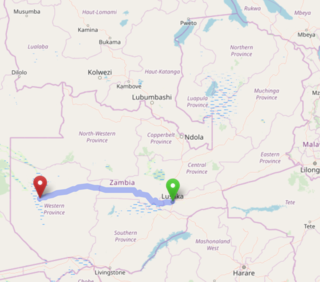
The Lusaka–Mongu Road of Zambia runs 580 km from the capital, Lusaka, to Mongu, capital of the Western Province. It connects that province to the rest of the country, as well as being one of two routes to the south-west extremity of North-Western Province. It also serves as the main highway of the western half of Central Province. The entire route from Lusaka to Mongu is designated as the M9 road.

The T2 is a trunk road in Zambia. The road runs from the Tunduma border with Tanzania via Mpika, Kabwe and Lusaka to the Chirundu border with Zimbabwe. The road is the longest route of the country, as it is approximately 1,155 kilometres (718 mi). The route from Mpika to Kafue is a toll road. The route from Tanzania to Lusaka is Zambia's Great North Road and is part of the Tanzam Highway.
The M1 road is a road in northern Zambia. It connects Mpika in Muchinga Province with Mbala in the Northern Province on the border with Tanzania and the Lake Tanganyika port of Mpulungu via Kasama. The northern section is a toll road.
The M14 is a road in the Muchinga Province of Zambia that connects Nakonde with the Malawian Border at Katumbi via Chitipa, Thendere and Muyombe.
The M1 road is a road in Malawi. The road serves as the backbone of Malawi's transportation network, stretching from the country's northern border with Tanzania at Kasumulu all the way down to the southern border with Mozambique at Marka. The north-south artery passes through the capital city of Lilongwe and the commercial hub of Blantyre, covering a total distance of 1,140 kilometers. As the longest road in Malawi, the M1 plays a role in connecting the country's major urban centers and facilitating trade and travel..
The M3 road, also known partially as the Blantyre-Zomba road, is a road in Malawi. The road stretches across the southern region of Malawi, tracing a north-south path that spans 236 kilometers. Beginning in the bustling city of Blantyre, the route winds its way through the scenic landscape to Mangochi, before continuing onward to the Mozambican border at Chiponde, providing a connection between the two countries.

The M22 road is an east–west route located in the northern part of Malawi, connecting the M1 highway to the town of Mzimba. Spanning a total length of 24 kilometers, the road plays a role in linking the key locations in the region.
The M2 is one of the main roads in Malawi. The road works as transportation artery in Malawi, stretching 113 kilometers in east-west direction across the southern region. Beginning in Blantyre, the country's second-largest city, the M2 traverses the scenic landscape to reach the border with Mozambique at Thornwood, providing a link between the two countries.
The M6 is one of the main roads in Malawi. It acts as a transportation link in Malawi, spanning 57 kilometers in east-west direction across the southern region. Beginning at the M1 junction near Zalewa, the M6 traverses the scenic landscape to reach the border with Mozambique near Mwanza, providing a connection between the two nations.
The M4 road is a road in Malawi. The M4 road serves as an east–west link in southern Malawi, providing a shortcut between Blantyre and Cisitu. As a spur route of the M2, it offers a more direct path for travelers, spanning a total distance of 45 kilometers. The route enables efficient connectivity between key locations in the region.
The M7 road is a road in Malawi that stretches 83 kilometers through the heart of the country. The route traverses a north–south trajectory, connecting the region north of the capital city Lilongwe to the town of Mbobo, providing a link between central Malawi's major population centers and economic hubs.
The M8 road is the road in Malawi that serves as an east–west connector in southern Malawi, bridging the gap between the major routes M1 and M3. Spanning 35 kilometers, the road links the towns of Balaka and Liwonde, facilitating efficient travel and trade between the region's important population centers and economic hubs.
The M10 road is a road in Malawi that stretches 19.36 kilometres along the southern shores of Lake Malawi. The key route connects the towns of Mtakataka and Mangochi, providing a link between the region's population centers and economic hubs, and facilitating the flow of trade and commerce across the scenic southern landscape.
The M11 road is a road in Malawi that stretches about 12.96 kilometers along the shores of Lake Malawi, connecting Timbiri and Chiweta. However, the road's development has stalled, leaving a substantial gap in its route. While some sections exist as dirt roads or tracks, a significant portion of the M11 remains a missing link, hindering the creation of a seamless north–south passage along the lake's scenic shoreline.

Roads in Malawi are an important mode of transport in Malawi. Malawi has 15,451 kilometers of road network by 2016 of which 28% was surfaced. There were 3,357 km of principal roads within the country with majority paved having 2976 km smooth tarmac. A different scenario came in 2014 when a certain report indicated that 38% of tarred routes were top shape, 40% had deteriorated though still passable while the remaining 22% required fixing.

