Related Research Articles
Public transport is the main means of transportation in Eswatini. Car ownership is low, at 89 cars per 1,000 people (2014). The National Road Network has 1500 km of main roads and 2270 km of district roads.

Mbabane is a city in Eswatini, and is one of the two capitals, serving as the executive capital.

A hairpin turn is a bend in a road with a very acute inner angle, making it necessary for an oncoming vehicle to turn about 180° to continue on the road. It is named for its resemblance to a bent metal hairpin. Such turns in ramps and trails may be called switchbacks in American English, by analogy with switchback railways.

Lobamba is a city in Eswatini, and is one of the two capitals, serving as the legislative, traditional, spiritual, seat of government of the Parliament of Eswatini, and Ludzidzini Royal Village, the residence of Queen Ntfombi, the Queen Mother.

Manzini is a large city in Eswatini (Swaziland), which is also the city of Eswatini's Manzini Region. The city is the country's second largest urban center behind the capital Mbabane, with a population of 110,000 (2008). It is known as "The Hub" of Eswatini and lies on the MR3 road. Eswatini's primary industrial site at Matsapha lies near the town's western border.

Ngwenya is a town in western Eswatini, lying near the border with South Africa, north west of Mbabane, on the MR3 road. The South African town opposite Ngwenya is Oshoek in Mpumalanga province.
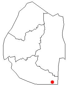
Lavumisa is a town located in the Shiselweni district of southern Eswatini.
Siphofaneni is a town in the Lubombo Region of central Eswatini (Swaziland), 45 kilometres from Manzini and 20 kilometres from Big Bend, a major sugarcane-producing town on the main highway leading to Durban. It has a tropical climate, very hot during summer and cold in winter. Malaria is endemic in Lubombo. Siphofaneni has hot springs and is surrounded by several sugarcane farms. It is located on the banks of the largest river in Swaziland, the Usutu.
Mpaka is a town in eastern central Eswatini in western Lubombo District. It lies about 22 kilometres (14 mi) northwest of Siteki on the MR3 highway.
Highway 26 is a highway in the western portion of the Canadian province of Saskatchewan. The southernmost point is a junction with Highway 4, north of North Battleford. From there, it runs generally northwest, including a 29 km concurrency with Highway 3 from just north of Turtleford to just south of St. Walburg, where it turns to a more northerly route. Highway 26 continues north until it terminates at a junction with Highway 224 and Highway 950, at the northern edge of the village of Goodsoil.

Victoria Bridge is a road bridge running north–south between Datchet and Windsor, Berkshire, England. It crosses the River Thames on the reach between Old Windsor Lock and Romney Lock. It was rebuilt in 1967 to replace a damaged bridge.

Antônio Carlos is a Brazilian municipality located in the state of Minas Gerais. Its population as of 2020 was 11,459 people living in an area of 530 km². The elevation is 1,058 meters. The city belongs to the mesoregion of Campo das Vertentes and to the microregion of Barbacena. The important regional center of Barbacena lies 13 km. to the north and is connected by highway MG-135. Antônio Carlos is on the railroad line that connects with Juíz de Fora.
Luyengo is a town in western Eswatini. It is located 35 kilometres south of the capital, Mbabane, on the MR18 highway, at the junction of the road south to Mankayane and Mgazini.
Mafutseni is a town in central Eswatini. It is located to the northeast of Manzini and Hhelehhele at the junction of the MR3 route to Mpaka and the MR5 route to Mpisi.
MR3 or MR-3 may refer to:

The N17 is a national route in South Africa which runs from Johannesburg to Oshoek (Ngwenya) on the border with Eswatini. It passes through Springs, Bethal and Ermelo.

Hlane Royal National Park is a national park in Eswatini, roughly 67 km northeast of Manzini along the MR3 road. Prior to being designated a public park, it was a private royal hunting ground. Hlane, meaning 'wilderness', was named by King Sobhuza II. It is now held in trust for the nation by His Majesty King Mswati III, and is managed by Big Game Parks, a privately owned body.
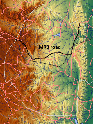
The MR3 road, also known as the Matsapha–Mbabane–Ngwenya road or Road No. MR3, is a major highway of Eswatini. It is one of the busiest roads in the country, crossing it from east to west. Along with the MR7 and MR8 roads, it forms the "backbone of Swaziland's internal transport system." It connects the EN5 road in Mozambique near Namaacha at 25°59′21″S31°59′53″E to the N17 road in South Africa at 26°12′45″S30°59′18″E, near Ngwenya. The road passes through Hlane Royal National Park and through the capital of Mbabane, about 110 kilometres (68 mi) further to the southwest. The highway descends into the Ezulwini Valley in four lanes. At Manzini, a bridge crosses the Mzimene River.
Ezulwini Valley is a valley of northwest Eswatini. Also known as "The Valley of Heaven", the valley lasts for about 30 kilometres, and is bounded to the east by the Mdzimba hills. The historical capital of Eswatini Lobamba is located in the valley, also known as the Royal Valley, a place of many legends of Swazi history. The main highway is the MR3 road; some parts have four lanes. The valley extends as far down as Kwaluseni. The valley contains a number of notable wildlife sanctuaries and features including the 4,500-hectare Mlilwane Wildlife Sanctuary and the Royal Swazi Sun Hotel. The valley is undergoing significant development with the growth of Tourism in Eswatini, with the building of casinos, bars, hotels, shops such as the Gables Shopping Centre and urbanization. Also of note is the Ezulwini Handicrafts Centre and Swazi National Museum in Lobamba. Despite the urban developments in the valley, the landscape still has some "soft green hills and plains-game grazing in the lush lands below."
The MR7 road, also known as the Mbandzeni highway, is a major highway of Eswatini. Despite being a relatively short road, along with the MR3 and MR8 roads it is considered to form the "backbone of Eswatini's internal transport system." It connects the MR3 and MR16 roads northeast of Siteki with Mozambique near Goba.
References
- ↑ International Road Federation (1 January 1993). World highways. Route One Publishing. Retrieved 22 March 2012.
| | This African road or road transport-related article is a stub. You can help Wikipedia by expanding it. |
| | This Eswatini-related article is a stub. You can help Wikipedia by expanding it. |