The Mozambique Channel is an arm of the Indian Ocean located between the Southeast African countries of Madagascar and Mozambique. The channel is about 1,600 km (1,000 mi) long and 419 km (260 mi) across at its narrowest point, and reaches a depth of 3,292 m (10,800 ft) about 230 km (143 mi) off the coast of Mozambique. A warm current, the Mozambique Current, flows in a southward direction in the channel, leading into the Agulhas Current off the east coast of South Africa.

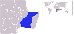
Eswatini, officially the Kingdom of Eswatini, also known as Swaziland, is a landlocked country in Southern Africa. It is bordered by Mozambique to its northeast and South Africa to its north, west and south. The country and the Swazi people take their names from Mswati II, the 19th-century king under whose rule Swazi territory was expanded and unified.

Eswatini is a country in Southern Africa, lying between Mozambique and South Africa. The country is located at the geographic coordinates 26°30′S31°30′E. Eswatini has an area of 17,363 square kilometres, of which 160 are water. The major regions of the country are Lowveld, Midveld and Highveld.
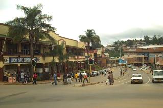
Mbabane is the capital and largest city in Eswatini. With an estimated population of 94,874 (2010), it is located on the Mbabane River and its tributary the Polinjane River in the Mdzimba Mountains. It is located in the Hhohho Region, of which it is also the capital. The average elevation of the city is 1243 meters. It lies on the MR3 road.

Mpumalanga is a province of South Africa. The name means "east", or literally "the place where the sun rises" in the Swazi, Xhosa, Ndebele and Zulu languages. Mpumalanga lies in eastern South Africa, bordering Swaziland and Mozambique. It constitutes 6.5% of South Africa's land area. It shares borders with the South African provinces of Limpopo to the north, Gauteng to the west, the Free State to the southwest, and KwaZulu-Natal to the south. The capital is Mbombela (Nelspruit).

Manzini is a region of Eswatini, located in the center-west of the country. It has an area of 4,093.59 km² and a population of 355,945 (2017), and is divided into 16 tinkhundla. Its administrative center is Manzini. It borders all three other regions: Hhohho in the north, Lubombo in the east, and Shiselweni in the south. It is bordered by the Mpumalanga province in South Africa to the west.

Makassar Strait is a strait between the islands of Borneo and Sulawesi in Indonesia. To the north it joins the Celebes Sea, while to the south it meets the Java Sea. The Mahakam River of Borneo empties into the strait.
Nsoko is a town in southern Eswatini about five kilometres (3.1 mi) from the border with South Africa. It lies about 65 kilometres (40 mi) north-east of Lavumisa and 45 kilometres (28 mi) south-east of Maloma. The town lies on the Ngwavuma river.

Bulembu is a small town located in northwestern Hhohho, Eswatini, 10 km west of the town of Piggs Peak. Located above the Komati Valley in Swaziland’s Highveld, Bulembu is named after the siSwati word for a spider's web.
Sandlane is the westernmost town in Swaziland. It is located close to the border with South Africa, 40 kilometres southwest of the capital, Mbabane.
Lundzi is a town in western Swaziland. It is located close to the border with South Africa, 25 kilometres west of the capital, Mbabane.
Mgazini is a town in southwest Swaziland. It is located close to the South African border, between the towns of Mankayane and Sicunusa.
Mafutseni is a town in central Swaziland. It is located to the northeast of Manzini and Hhelehhele at the junction of the MR3 route to Mpaka and the MR5 route to Mpisi.
Motjane is a town in northwestern Swaziland. It is located on the MR1 route 15 kilometres to the northwest of Mbabane, on a junction with a route crossing into South Africa near the town of Ngwenya. It was reported by The Rudolph Aggregates to have a listed population of under 500 inhabitants

Rochowice is a village in the administrative district of Gmina Borów, within Strzelin County, Lower Silesian Voivodeship, in south-western Poland. Prior to 1945 it was in Germany.

Malolotja National Park covers 18,000 hectares of mountain wilderness on Eswatini's north western border with South Africa. The park includes Ngwenya Mountain, Swaziland's second highest mountain, and Malolotja Falls which drop 89 metres (292 ft), the highest in Swaziland. Habitats include short grassland to thick riverine scrub, bushveld and Afromontane forest.

Severe Tropical Storm Domoina in 1984 caused 100 year floods in South Africa and record rainfall in Swaziland. The fourth named storm of the season, Domoina developed on January 16 off the northeast coast of Madagascar. With a ridge to the north, the storm tracked generally westward and later southwestward. On January 21, Domoina struck eastern Madagascar, the third storm in six weeks to affect the nation; collectively, the storms caused 42 deaths and $25 million in damage (1984 USD). After crossing the country, Domoina strengthened in the Mozambique Channel to peak 10 minute sustained winds of 95 km/h (60 mph). On January 28, the storm made landfall in southern Mozambique, and slowly weakened over land. Domoina crossed into Swaziland and later eastern South Africa before dissipating on February 2.
Gege is a town in the Shiselweni district of southern Eswatini.


